Casterton Land System
 |
|
| In this study, certain land-systems are discussed in more detail than others and the Casterton land-system is one of them. It is a good example of a landscape in which one particular factor of the natural environment, namely, the parent material, interacting with the other factors, has dominated the development of the landscape and the nature of the soils and vegetation, has dominated the history of land-use and the erosion hazard, and has a big influence on potential land-use. The factual data on the environment is presented in such a way that this dominance of a distinctive parent material is evident. This has been done because an understanding of the processes operating within the system provides a better appreciation of the difficulties, treatment and potential productivity of the land.
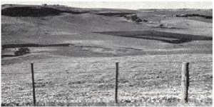
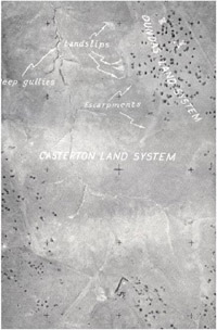
Nature and extent of Land-system Where the Dundas Tablelands are dissected, the rocks exposed may be considered conveniently in two groups. One contains a variety of chiefly acidic rocks-acidic igneous rocks and Tertiary sediments, mainly and the areas where these are exposed are grouped together collectively as the Glenelg land-system. The other is of predominantly fine-grained calcareous sedimentary rocks and on these areas the landscape has been mapped as the Casterton land-system. The features of this landscape are the generally treeless dark heavy soils, a sharp escarpment at the junction with the tablelands, deep valleys with concave lower slopes and flat valley floors. |
The Casterton land-system extends over most of the area between and around Merino, Coleraine and Casterton and separates the two sub-systems of the Glenelg land-system so that to the north-east, the Glenelg land-system is mainly of earlier Palaeozoic rocks, whilst to the south-west, it is mainly of later rocks, early Cainozoic capping upper Mesozoic. It may be seen that the dissected rocks show an age sequence along a west-south-westerly line, transverse to the general direction of faulting which is north-north-westerly. The Casterton land-system is simply those dissected areas where the exposed rocks of this age-sequence are predominantly soft, lime-rich and high in clay-forming materials, namely the Mesozoic sediments together with small areas of calcareous Permian glacial rocks, for it is these rock characteristics which eventually lead to the typical features of the land-system. By contrast, the Glenelg land-system with its different pattern of soils, topography and vegetation, is found where other kinds of rock have been exposed.
Parent Material
The Mesozoic sediments of this area were originally considered to be only Jurassic. Kenley (1953) showed that they extend, without change in the overall lithological pattern, into the early Cretaceous and he has named the whole Jurassic and early Cretaceous sequence in this area the Merino Group. These sediments consist, as do most areas of Jurassic rocks in Victoria, of interbedded mudstones(claystone and siltstone) and arkose (felspathic sandstone) with occasional beds of breccia, conglomerate and impure coal. Mudstones predominate, forming about60 to 80 per cent of the thickness and are composed of clay, some of it capable of base-exchange and of the swelling type, quartz of the size of silt and fine sand and some felspars (Edwards and Baker 1943). Arkoses consist of fresh felspars, fine sand, some biotite and fragments of intermediate lava, all in a matrix of chlorite which has sometimes been replaced by calcite, giving bands of calcareous arkose and cannon-ball limestone. Edwards and Baker (ibid) remark on the high quantities of lime and soda in both mudstones and arkose, of high phosphorus in the arkose, although not in the mudstone, and of the potassic nature of the mudstones. Both Kenley and Boutakoff refer to the soft nature of the Merino Group sediments. From all this, it is clear that the Merino Group rocks are soft, rich in lime and soda, and high in clay-forming minerals, lack a coarse fabric, are well supplied with potassium and moderately supplied with phosphorus. These features together are chiefly responsible for the character of the landscape, soils, erosion status and land-use of the Casterton land-system and their influence is traced below.
Influence Of Parent Material On Development Of Landscape
The softness of the rock allows a rapid rate of down-cutting in relation to the rate of widening of the valley. There are a number of consequences of this for regional landscape formation.
The first is that in the early stages of dissection of a land-surface, streams can become easily entrenched in any surface weakness and the resultant direction of flow is imposed on the later history of those streams. The chief regional direction of faulting is north-north-westerly and the regional fall of the land in the Casterton-Merino area is transverse to it, namely, west-south-westerly and it may be expected that the influence of the direction of tectonic weakness on the streams dissecting up along the line of fall would be strongest where the underlying material is relatively soft. This is so for the two chief streams of the survey area, the Glenelg and Wannon Rivers, the beds of which, within the area of Mesozoic sediments, extend in the direction of faulting departing from this only after leaving the area of Merino Group formations. Their chief tributaries within the Casterton land-system, the Wando River and Miakite Creek do this also. As a result, the land-system shows a generally north-north-westerly orientation, apart from an extension up the valley of the Konongwootong Creek, where it is formed on calcareous Permian glacial deposits. Isolated tableland residuals within the land-system and the fringing tablelands show this orientation most markedly.
A second consequence is that the sides of the valley are steep in the juvenile stages of erosion, particularly where the hard capping remains. After the capping has been removed, senile stages of erosion can develop quickly, the topography becoming progressively subdued to rounded hills with convex upper and concave lower slopes. Another result of rapid down-cutting is that the maximum depth to which dissection can proceed is quickly reached, and is controlled by the level of the chief stream after it has left the area of soft rocks. Therefore, the landscape is deeply dissected in relation to nearby areas of other rocks. Finally, once entrenched within softer rocks, the beds of the streams tend to develop within the boundaries of those rocks as these allow a greater rate of headward erosion and so a relatively high proportion of the streams' courses is confined to such rocks. This, together with the fact mentioned above that the similar, maximum, depth of dissection can be quickly reached within the area of softer rocks, results in a low grade of the main streams within that area ant induces the formation of flood plains, meanders and alluvial deposits. In the Casterton land-system these are sufficiently distinct and important to be mapped separately as the Wannon land-unit of the Casterton land-system.
All the features mentioned above-deep valleys with steep sides and escarpments adjacent to the tablelands, rounded hills with concave lower slopes, wide flood-plains and occasional strongly orientated tableland residuals - are characteristic of the land-system. They are the results primarily of the softness of the rock underlying the hard laterite, although, as Marker (1959) suggests, the tendency of the soils to slumping has augmented this, and such a tendency arises from the nature of the soils and thus indirectly from the characteristics of the parent material.
Influence of Parent Material on development of Soils
A high content of calcium has two important effects in the soil; it favours the formation and preservation of a swelling type of clay mineral and it flocculates soil suspensions.
The soft and calcareous nature of the Mesozoic sediments, weathering quickly to provide much calcium in the soil, has encouraged the formation of this type of clay mineral from the unweathered felspars, augmenting the already weathered clay which Edwards and Baker (1943) consider to be of the swelling type.
Flocculation of soil colloids affects the texture profile by retarding the downward movement of the colloids so that in soil material lacking an open fabric, flocculation results in a soil with a uniform texture profile. If the amount of clay or clay-forming material be substantial, as in the Mesozoic sediments, then the soil is uniformly heavily-textured.
Flocculation also affects soil structure. Dispersed colloidal suspensions, such as those saturated with a monovalent cation like sodium, dry out to massive structure with a non-swelling colloid, or large massive blocks with swelling colloids. These re-wet only slowly, forming in the first stage amorphous slippery surface on any large blocks. Colloidal suspensions flocculated with a divalent cation like calcium, dry out to moderately sized structural units, owing to rupture along lines of weakness between aggregates. Such structural units in the dry state are strongly formed, especially with a swelling clay, although in the moist state they close up.
However, salt of calcium and sodium can themselves be leached by rainwaters, sodium salts the more quickly and more deeply because they are more soluble. As a result, under rainfalls where the salts or ions of sodium are appreciable only in the subsoil, calcium salts or ions, provided that they were originally present in substantial amounts, as they are in the Mesozoic sediments, are still present in appreciable proportions in the upper part of the profile.
Thus, in an area of moderate rainfall, where the parent material is Mesozoic sediments, which are calcareous, soda-rich, without an open fabric and containing abundant clay-forming minerals or clay particles, the soils have the following features:
- uniformly heavy texture down the profile ; swelling clay throughout and therefore deeply cracking when dry but tightly closed when wet ; strong medium-sized structural units at the surface due to calcium
- larger, well-formed units in the subsoil, because of sodium on the exchange complex, the faces of the units being slippery when first wetted.
Soils Encountered
The features enumerated above are in fact the important characters of the chief soils of the Casterton land-system and are summarised by Blackburn and Leshe (1958) as the common features of "the black earths below tableland level."
On the Mesozoic sediments, the chief soils comprise three series of prairie soils or chernozems in topographic association or catena. They are the Coleraine series on the convex or upper concave slopes, the Whyte series in drainage lines in concave slopes or on colluvial outwash and fan deposits, and the Wannon series on the alluvium of the flood plains of major streams. A description of the Whyte series exemplifies the chernozem group, whilst analytical data for the same profile and for representatives of the Coleraine and Wannon series are presented in Appendix II. Analyses show that the three series differ somewhat in clay content and pH values, these criteria being greater and higher, respectively, in the series with lower topographic position. Otherwise, however, they are similar in having the features mentioned above, together with a high status of nitrogen and a favourable C/N ratio at the surface, a high status of potassium in all horizons and a moderate supply of total phosphorus. The content of this latter element, however, is still higher than for most other soils of the survey area, except for the brown earths on the younger basalt flows.
The Permian deposits along the right bank of the Konongwootong Creek, being calcareous and fine-grained, give rise to chernozems or prairie soils named by Blackburn and Leslie the Bellwyn series. Whyte series soils again form on colluvial and outwash fan deposits from areas of the Bellwyn series, which closely resembles its analogue on the Mesozoic deposits, the Coleraine series.
Earth flows commonly develop on the dark clays where slopes are steep enough and some of the present soils in such places are formed from old earth flows. Such soils are mainly of Order VII ("The Earths") and usually are prairie soils or chernozems; Blackburn and Leslic map them as Soil Complex 4. Localised areas of solodic soil,. and leptopodsols, some of them mapped as the Hilgay series by Blackburn and Leslie now occur on the tops of some hills eroded to just below tableland level. They are derived from the thin veneer of Tertiary sands which overlies some areas of Mesozoic beds at about tableland level. Also restricted to similar positions are gravelly red soils formed from lateritic material, but mostly such soils fringe the tablelands at the top of the escarpment and have been mapped with the soils of the tablelands. Occasional areas of volcanic rock occur within the boundaries of the land-system and they produce either soils of Order VII or skeletal soils, according to topography.
For the land-system in general, by far the greatest proportion of the soils are of Order VII and most of them are either prairie soils or chernozems of moderately high chemical fertility. Of these, the Coleraine, Whyte and Wannon series are the most common. They are the chief examples in the survey area of the "black earths" and of Order VII.
Influence of Soils and Climate on Native Vegetation
Most of the land-system was a treeless grassland before white settlement. The only eucalypts found now are red gums fringing creek lines except in the extreme south-west of the land-system where they extend onto the slopes, possibly because of the higher rainfall there and it is on this basis that the Merino land-unit has been separated. This accords with early records and the early parish plans and is not the result of clearing. The first survey of the parish of Merino in 1855 records, for the area south-east of the township, "land of superior quality not timbered", and for that north of the township, "land of good quality lightly timbered with blackwood", with gums pinpointed near creek lines. Robertson (1853) described land near the Wannon as having only blackwoods and another acacia "in every sheltered nook". Scattered she-oaks are found now on the small areas of sandy sediments on the Hilgay series or on red soils on lateritic remnants adjacent to the tablelands. The bulk of the land-system however, was a grassland of perennial grasses, mainly Stipa spp., Themeda spp., Poa spp. and Juncus spp.
Doubtless the reason for the absence of eucalypts over most of the land-system is the physical nature of the soils combined with the wet cold winters and the hot dry summers which create in the plant a high demand for water. In the drier parts of the survey area during summer the potential evapo-transpiration greatly exceeds rainfall and to survive, plants must explore with their roots a volume of soil with a reserve of available water sufficient for their requirements. Non-aestivating perennials therefore must have a deep-rooting system, except where special conditions of slope and soil allow a perched water table to persist well into the summer.rigid and extensive root system such as that of trees; during winter, however, the same soil is badly aerated because it swells when wet, and the cracks and pores become closed.
A wide range of soil conditions in the area will allow deep-rooted perennials to survive, but some soils impose stresses. Thus, a soil which has wide and deep cracks when dry, puts a mechanical strain furing the summer on a rigid and extensive root system such as that of trees; during winter, however, the same soil is badly aerated because it swells when wet, and the cracks and pores become closed.
The most serious aspect of such a soil, however, is that it severely curtails the ability of deep roots to continue supplying the water needs of perennials during the summer, because of the high tension at which water in the soil is withheld from plants. In sandy soils, because they have large pores, a small quantity of water can lower water tension swiftly to the point where water is available for plants and there is a quick response to summer showers. By contrast, silts and clays because of their smaller pore sizes can develop high water tensions. In these cracking soils evaporation can dry out the soil to below the wilting point and, because small quantities of water will not lower the water tension significantly, there can be no quick response to light summer rains. Consequently, once the soil dries out to the point where wide and deep cracks form, there is no further plant growth until after substantial rains, which in the climate of the Casterton area, will not normally occur until the break of the season.
Furthermore, plant growth may stop quite suddenly in these soils. This is because plant roots cannot usually penetrate pores of diameter less than about 510inch, the pore size commonly associated with the coarser grades of fine sand (Russell 1953), and water held in pores of that size or less is unavailable. In these soils, with a high content of silt and fine sand, there is a sudden change in the proportion of pores in that range of size, and consequently a sudden and drastic change in the availability of water during the drying-out period.
All these features which impose stress on deep-rooted perennials are characteristic of the dominant soils of the Casterton land-system. The moderate to high contents of a swelling-type clay, capacity for forming wide, deep cracks, high content of silt and finer grades of fine sand and the virtual absence of coarse sand and the coarser grades of fine sand, all combine to create difficult conditions for non-aestivating deep-rooted perennials in the climate of the Casterton-Coleraine district.
None of the eucalypts native to the region are fully adapted to such conditions, and it is interesting that it is only along some of the creek lines or bigger water-courses that red gums grow. These creeks are usually slightly entrenched so that the water-table fringing them is not at the surface for a long period during winter to thus induce badly-aerated conditions; yet, because of the topographic position, the deep subsoil remains moist during the summer. A likely explanation for trees fringing creeks therefore is the absence of wide fluctuations between lack of aeration at the surface during winter and high water tensions extending into the deep subsoil during summer. A relatively shallow-rooted eucalypt like swamp gum is excluded from the whole landscape by its inability to withstand high water tensions at the surface during the summer. A deeper-rooted species like red gum is excluded from all except the creek-lines, where water is available within the depth of the rooting system, both, by an inability to withstand high water tensions and probably also, in contrast to swamp gum, by an inability to withstand lack of surface aeration during winter.
It is interesting that where summer stress on such soils is eliminated as at Heywood with a 32 inch rainfall and more frequent summer showers as well as a wetter topographic position, similar soils with a swelling clay support only swamp gums and shrubs like Melaleuea spp. and Leptospermum spp. which can survive badly aerated conditions during winter. They do not, however, support red gum, which tolerates such winter wetness less than does swamp gum - a fact which can be demonstrated around the edges of any swamp in the Strathdownie land-unit.
Significance for introduced Vegetation
The matter of soil physical conditions in relation to native plants in the Casterton land-system bears also on the growth of crops, pasture species and on the establishment of trees as conservation measures around gullies.
As an example, the chief difficulty in establishing trees is the generation of high water-tensions because of the drying out of a swelling-type clay. The effect of this can be ameliorated by raising the watertable through pushing in the sides and heads of the gully, and by lowering the ill-effect of the high swelling capacity of the clay through planting in sand. Also, species capable of rapid deep-rooting to reach zones of moisture quickly may be useful. Some species from the drier areas are better able to withstand the high water tensions of cracking clays in summer than can red gum but they also have a moderate degree of tolerance to water-logged surface conditions during winter. Such species may be suitable, provided that low temperatures or frosts do not inhibit them.
Influence of Soils, Vegetation and Climate on Land-use
The treeless and grassy nature of the Casterton land-system with the fertile appearance of the soils made it the most attractive for settlement, easiest to develop and most quickly rewarding country in the first days of settlement. The first eight inland stations in Western Victoria, all settled from Portland, were on the Casterton land-system. Merino Downs, Muntham, Sandford and Connell's Run were the settlements of the Henty family, and then came Murndal, Tahara, Hilgay and Wando Vale. The five settlements following these, at Dunrobin, Nangeela, Warrock, Cashmere and Wannon Falls are on the periphery of the land-system and included parts of adjacent land-systems, particularly Glenelg and Dundas. By the time the stream of settlement from eastern Victoria arrived in 1840, virtually the whole of the Casterton land-system, but not much outside it, had been taken up, and those settlers just arriving occupied the remainder of the Glenelg and Dundas land-systems,
The grasslands were eminently suitable for the grazing of fine-woolled sheep and some cattle. This was the main enterprise of the land-system until the end of the First World War when some of the land as around Paschendale, was subdivided into dairy farms for soldier-settlers. Further subdivision after the Second World War has made dairying the dominant land-use over about one-third of the land-system, mainly to the north and east of Merino. Elsewhere, cross-bred wool growing with fat lambs is important, with some beef cattle raising. Dairying is based mainly on pastures of perennial ryegrass and subterranean clover with fodder crops like rape and chou-moellier to provide late summer and winter supplements.
However, the combination of soils and climate brings the active growth of many species to an abrupt end at about the middle to the end of November, without much likelihood of its starting again until the autumn break. Consequently, many cows are dried off or become dry during summer, as shown in Table 7. In the cold and wet winter, however, cows in milk have high food requirements for both maintenance and production, often more than can be provided by the feed which, at that time of the year, is sappy and, if the break be late, is in short supply also. Therefore, the area cannot be considered ideal for dairying for which a growing season of nine months is desirable. The answer to the problem may depend upon fodder conservation-hay and silage-fodder crops, forage crops and the use of very deep-rooting aestivating perennials like lucerne which can respond to the surface-moistening effects of slight summer rains as well as tapping deep-seated moisture reserves. In this way, by placing a higher demand on it, use can be made of the high level of soil fertility, for this is the chief asset of the soil and should be used more.
Beef cattle raising has its problems too. This rapidly growing industry is sensitive to a long dry summer and it is certain, also, that without supplementary feeding of stock, the cold wet winter seriously retards the achievement of condition in the animals. Greater use of fodder crops qnd fodder conservation will relieve some uncertainties and allow the earlier production of better stock condition.
Difficulties remain because both the time of cultivation and the moisture content of soil at cultivation are critical. Nevertheless, the soils have the capacity to sustain a more intense level of farming than is common at present without incurring excessive economic burdens of replacing nutrients or repairing structure. This could be decisive in a comparison of the potential land-use of this land-system with that of others where the soils are very low in nutrients.
Influence of Landscape and Soils on Erosion
Soil erosion in the land-system presents an unusual picture; sheet erosion is very restricted, yet there is some deep and spectacular gullying, localised severe siltation, frequent earth flows and virtually no salting. This arises from the unusual features of the soil and landscape, briefly summarised as follows. Escarpments fringe the tableland residuals, carrying red solodic soils or red leptopodsols. At a lower level, hills occur with steep convex upper slopes and gentler concave lower slopes; soils on the hills are heavy-textured prairie soils or chernozems with strong surface structure and sodium-saturated blocky subsoils, underlain, generally, by soft and loose sediments. Major streams and rivers are on very low grades and flood deposits abound.
It is on the escarpments or isolated areas of Tertiary sands with solodic soils or leptopodsols that sheet erosion occurs because sheep often camp there and severely tread soil of low coherence on a steep slope. Such areas are restricted, and despite severe erosion probably make little contribution to surface run-off lower down the slope.
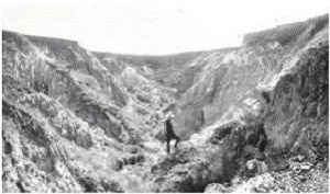
Elsewhere, on the prairie soils and chernozems, there is but little evidence of sheet erosion, because the surface soil, when dry, has structural units too coarse for transport and strong enough to resist breakdown by abrasion or raindrop splash, and when wet is coherent enough to resist detachment. However, despite the absence of widespread sheet erosion on the catchment, run-off waters have still concentrated in sufficient volume and velocity to cause gully erosion and many drainage lines in the lower concave slopes are cleft by a deep and sometimes wide gully which often extends uphill into the zone of convex slopes. (Plates 25 and 27).
Three factors have contributed to this. Surface run-off has followed low surface infiltration rates which were caused, not by compaction associated with the processes of sheet erosion but by the swelling of the surface soils after rain and the closing of the surface cracks and pores. The original dense cover of perennials was replaced by annuals, as a result of grazing, and these died off in the summer, leaving the surface bare. This allowed run-off water to concentrate quickly and acquire the velocity to dislodge the structural units of the soil at a point of disturbance such as an entrenched drainage line, a wide crack, old ploughland, or deep wheel ruts. Finally the normal processes of headward and gullyside erosion, namely undercutting and caving, have been augmented and hastened by the process of slumping. This has been caused by the slippery surface of large subsoil structural units arising from the sodium saturation of the swelling clay or kaolintic material and also from the prominent content of silt in the chief soils of the land-system. Slumping has contributed particularly to lateral erosion and gullies are, often wide.
| Sediments beneath the heavy black soils are soft and frequently unconsolidated gullies may become much wider and deeper by undercutting of the sediments with concentrated and turbulent flow or with waterfall splash, and then slumping or caving. Such severe gully and stream-bank erosion are characteristic of the zone where considerable runoff has been concentrated, namely the concave lower slopes in the Casterton land-system, just above the flat valley floors. From these places, considerable quantities of sedimentary and soil material have been removed. The sudden change to the low grade of the major streams caused the deposition of the flood deposits of pre-settlement days, upon which the rich Wannon series of soils has developed. The same conditions cause the deposition now of large quantities of infertile debris produced by gully and stream-bank erosion, and serious and detrimental siltation is common along the major streams where they are near the zone of lower slopes. Siltation material is from one or other of two sources - the soils and underlying sediments within the Casterton land-system and eroded areas of the adjacent Glenelg land-system. Deposits from the former source are found most frequently in the drier parts of the Casterton land-system, where gully and stream-bank erosion are more severe; the siltation of the Wando River above its junction with the Wando Vale Ponds Creek is an example. Deposits from the latter source are found where a major stream drains sandy or granitic areas of the Glenelg land-system before entering the Casterton land-system ; examples are the siltation of the Wando Vale Ponds Creek, the Koroite Creek and even the Glenelg River itself. |
Robertson of Wando Vale, settler and historian, writing in 1853, mentions the great increase in the number of earth flows on the middle and lower slopes shortly after settlement, but he also states that there were flows before settlement. It is clear from this and from the number of ancient earth flows now mantled with modern soils that the landscape has an inherent degree of instability even in the natural state, and earth flows have undoubtedly been a major factor in the rapid development of deep valleys in the Mesozoic rocks. Marker (1959) considers this point in detail. Events since settlement have merely hastened the processes involved in the instability. Robertson recounts that all drainage lines except the Glenelg and Wannon were originally sound, rarely entrenched and permanently covered right across with large tussock, and how these tussocks were eventually eaten out and replaced by annuals which dried off in the spring, to leave the ground bare and cracking in the summer. He talks of incipient salting and small gullies in drainage lines, then of large gullies and stream-bank erosion and finally of earth flows on all steep hills. His letters are a graphic statement of how, ten years after settlement, deterioration first appeared and two years later, most of the erosion forms with which we are familiar were widespread.
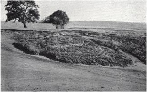 | 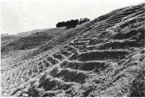 |
| Plate 26 and 26A - In the Casterton land-system, the soils are prone to mass movement on steep slopes. (The two most common forms are earth -flows, known locally as "landslips", and stock terracettes, which are pictured here.) | |
| Summary This chapter is an attempt to show the coherent and inter-related nature of one natural environment and to suggest a rational development of the various land-use features from the independent factors of the environment, chiefly parent material. Soft Mesozoic sediments, capped by harder Tertiary laterite have allowed senile landscape features to develop quickly with dissection whilst at the same time, wherever tableland cappings remain, features of a very juvenile topography have been preserved. Consequently, steep escarpments beneath the plateau surface, steeply-rolling hills and flat-floored valleys have been formed. Because of the lime-rich and fine-grained nature of the parent material and the prevailing climate, prairie soils and chernozems have been formed on most topographic positions-dark, heavy-textured, cracking soils, well structured at the surface and well supplied with most nutrients. These features have been largely responsible for the grassy vegetation and the lack of trees except along creek-lines, owing to the lack of moisture available to plants during the summer. The land-system was the first to be settled after Portland because of the attractive appearance of the soils and the open nature of the vegetation; the same reputation of being good land has led to closer settlement being much earlier on this land-system than on others. Some of the difficulties encountered with dairying however on the fertile-looking prairie soils and chernozems arise from those very features which have been largely responsible for the open grassy nature of the landscape; nevertheless the chemical fertility is an advantage which can be used to offset the physical disadvantages. The unusual picture of erosion in the Casterton land-system is of limited areas of sheet erosion, some very severe gully erosion and stream-bank erosion with slumping aiding in their extension, severe local siltation and abundant earth-flows with some solifluction. This can be traced to the nature of the soils and thereby indirectly to the parent material in the climate and topography of the land-system.
|

