Karst
This information has been developed from the publications:
|
Management of Karst Areas
Much of the Portland Shire is underlain by limestone on whch has developed a distinctive terrain known as karst. Karst terrain is due to the high solubility of limestone in water. The drainage of karst areas is often primarily underground and can occur in confined or unconfined aquifers or as underground streams. Underground water may travel considerable distances and may cross surface watersheds - hence the delineation of real drainage divides is often difficult. Surface stream flow is often intermittent and disorganised in karst areas.
The high solubility of limestone leads to a number of unusual weathering forms such as caves, sinkholes, dolines, rock pinnacles, solution pipes, rock pavements and microrelief features such as solution runnels (karren). The overall impression of a karst area is of a "pitted" landscape.
Karst features are of interest to a wide range of scientists e.g. for studies in geology, geomorphology, hydrology, zoology and archaeology. Caves may provide a number of economic benefits including refuges for bats such as Miniopterus schreibersii which act as an important biological control for insects.
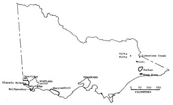
The figure below indicates the distribution of karst areas in Victoria. Most are small and have limited limestone outcrop, and the karst of the Portland Shire comprises one of the major karst landscapes in Victoria. For example, of the total known caves in Victoria (604), 127 are found in the Portland Shire.
Limestone areas shown on geological maps do not accurately depict the areas of karst landscape. Tertiary limestones are in places overlain and concealed by surficial deposits, e.g. sand sheets or alluvium and caves may occur beneath these.

Karst Areas in Victoria
The presence of extensive limestones in the Portland Shire has influenced the surface drainage system. The few major streams that occur are either located in the non-limestone areas, e.g. Stokes River, or like the Glenelg have headwaters in non-limestone areas and receive much water from undergrond sources.
Two distinctive karst landscape and cave types occur in the Portland Shire. These are related to the different properties of the limestone formations on which they have developed - the Heytesbury Group and the Bridgewater Formation. The Heytesbury Group limestones outcrop in the Heywood, Lower Glenelg, and Dartmoor areas forming an undulating surface with very little surface drainage. Small closed depressions are common and large dolines occur at Drik Drik.
Caves are typically joint enlarged under phreatic conditions with further enlargement by vadose water. Some caves have solution pipe entrances, e.e.g (G-10)* and a few are decorated with calcite speleotherms, e.g Princess Margaret Rose Cave (G-6). The caves are not particularly large in cavern size or length. Most are located in the Lower Glenelg National Park but some occur on private land, e.g. G-11 and G-12.
The Bridgewater Formation consists of distinctly bedded, calcareous dune sands. The karst features are syngenetic, i.e. the caves form as the dune sands are lithifying into rock with the process continuing to the present time. Although the karst features are not well known, they are widespread and some speleologists consider them to be more interesting than the karst of the Heytesbury Group. The caves in the Bridgewater Formation contain a number of decorations and some are relatively long, e.g. River Cave (BR-4) has over one kilometre of passage. The caves are typically linear and may have multiple entrances. Some entrances are solution pipes but most are small collapse dolines.
The caves in the Bridgewater Formation are of particular interest as examples of syngenetic karst. Caves of this origin are found in south-east South Australia and south-west Western Australia, but are reare in a world context.
Other karst features of the Bridgewater Formation include pitted and eroded bluffs and towers, e.g. at Tyrendarra and a recessed pavement at Cave Ridge. At Drik Drk are large dolines which extend into the underlying Tertiary limestones.
Along the coast at Cape Bridgewater and Cape Nelson are sea caves which have been formed by weathering and erosion of the basalt cliffs. Although not considered as karst features, they contain some calcareous accumulations such as speleotherms and tufa terraces. These result from the action of ground water which dissolves carbonate from the overlying Bridgewater Formation limestones and leaves evaporite deposits where it emerges into the cliff face or the walls, floor and roof of the cave.
Fossil sea caves with old speleotherms are found in former marine cliffs near Bridgewater Lakes.


