
SW7
Location: Terang
Australian Soil Classification: Ferric-Sodic, Eutrophic, Brown CHROMOSOL
General Landscape Description: Level volcanic plain.
Site Description:
Land Unit:
Geology: Quaternary basalt (Qvn)
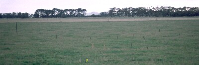 SW7 Landscape |
Soil Profile Morphology:
Surface Soil
| A1 | 0-10 cm | Dark brown (10YR3/3) light fine sandy clay loam; moderate medium blocky structure; very weak consistence moist; pH 5.8; clear change to:
| 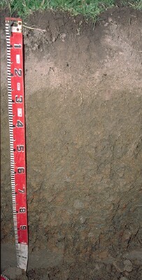 SW7 Profile |
| A21 | 10-17 cm | Brown (10YR4/3) light fine sandy clay loam; sporadically bleached in patches; moderate medium blocky structure; very weak consistence moist; pH 5.9; abrupt change to:
| |
| A22 | 17-25 cm | Brown (10YR4/3) light fine sandy clay loam; very firm consistence moderately moist; contains many (50%) ferruginous concretions (2-10 mm size) pH 6.3; abrupt change to: | |
| Subsoil | |||
| B21 | 25-40 cm | Dark yellowish brown (10YR4/4) with brownish yellow (10YR6/6) mottles; light medium clay (subplastic); parting to strong medium polyhedral structure; very firm consistence moderately moist; pH 6.8; clear change to:
| |
| B22 | 40-70 cm | Brown (10YR4/3) with brownish yellow (10YR6/6) and red (2.5YR5/8) mottles; medium clay (subplastic); weak to moderate coarse prismatic, parting to strong medium to fine polyhedral structure (smooth-faced peds); very firm consistence moderately moist; contains very few (2%) manganese flecks; pH 7.0; gradual change to:
| |
| B23 | 70 cm+ | Brown (10YR5/3) with brownish yellow (10YR6/6) and red (2.5YR5/8) mottles; medium clay (subplastic); moderate to strong coarse prismatic, parting to strong coarse blocky structure; strong consistence moderately moist; pH 6.4. |
Key Profile Features:
- Strong texture contrast between surface (A) horizons (< 21% clay) and subsoil (B21) horizon (70% clay).
- Presence of an ironstone gravel ('buckshot') zone in the subsurface horizon.
Soil Profile Characteristics:
- | pH | Salinity | ||
Surface Soil (A1 horizon) | Moderately Acid | Low | Non-Sodic | - |
Subsoil (25-40 cm) | Slightly Acid | Very Low | Non-Sodic | None |
Deeper Subsoil (45 -60 cm) | Slightly Acid | Low | Sodic | None |
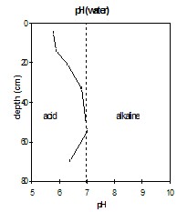 | 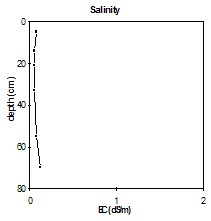 | 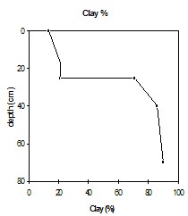 | |
| The upper surface horizons are moderately acid. The upper subsoil is slightly acid to neutral. The deeper subsoil is slightly acid. | The salinity rating is very low throughout the soil profile. | The clay percentage increases abruptly at the A/B horizon boundary. |
Chemical and Physical Analysis:
Horizon | Horizon Depth (cm) | pH (water) | pH (CaCl2) | EC dS/m | Organic Carbon % | Total Nitrogen % | Exchangeable Cations | Coarse Sand (0.2-2.0 mm) % | Fine Sand (0.02-0.2 mm) % | Silt (0.002-0.02 mm) % | Clay (<0.002 mm) % | Wilting Point % w/w | |||
Ca | Mg | K | Na | ||||||||||||
meq/100g | |||||||||||||||
A11 | 0-10 | 5.8 | 4.9 | 0.8 | 2.8 | 0.31 | 3.8 | 0.82 | 0.42 | 0.26 | 15.3 | 45.4 | 19.5 | 13.5 | 9.6 |
A21 | 10-17 | 5.9 | 5.0 | 0.05 | 1.6 | 3.1 | 0.71 | 0.11 | 0.10 | 15.7 | 47.6 | 20.5 | 13.5 | 6.3 | |
A22 | 17-25 | 6.3 | 5.3 | 0.05 | 5.3 | 3.3 | 15 | 0.22 | 0.13 | 23.3 | 39.2 | 16.0 | 21.0 | 7.8 | |
B21 | 25-40 | 6.8 | 5.8 | 0.05 | 3.1 | 6.7 | 6.2 | 0.29 | 0.47 | 7.8 | 15.7 | 4.5 | 70.5 | 26.4 | |
B22 | 40-70 | 7.0 | 6.2 | 0.08 | 6.3 | 7.5 | 0.27 | 0.78 | 4.2 | 8.8 | 1.5 | 86.0 | 31.5 | ||
B23 | 70+ | 6.4 | 5.9 | 0.12 | 4.9 | 9.3 | 0.26 | 1.1 | 3.0 | 7.4 | 0.5 | 90.0 | 33.9 | ||
Management Considerations:
Whole Profile
- Plant available water capacity (PAWC) is considered to be medium (estimated at 145 mm) for the top metre of this soil profile. This is based on available laboratory data. Effective PAWC is likely to be lower than this value as rooting will be restricted by the coarsely structured upper subsoil.
© State of Victoria (Agriculture Victoria) 1996 - 2025.

This work, Victorian Resources Online, is licensed under a Creative Commons Attribution 4.0 licence. You are free to re-use the work under that licence, on the condition that you credit the State of Victoria (Agriculture Victoria) as author, indicate if changes were made and comply with the other licence terms.
The licence does not apply to ‘branding’ or some ‘images or photographs’ that may be owned by third parties. We ask you to seek prior approval to use images using the VRO feedback form. Access to higher quality images can also be provided on request.
This page was last updated on 23/03/2020.