
SW6a
Location: Garvoc
Australian Soil Classification: Bleached-Ferric, Natric, Brown KUROSOL
Northcote Factual Key: Dy 3.41
Great Soil Group: soloth
General Landscape Description: Gently undulating volcanic plain.
Site Description:
Land Unit:
Geology: Quaternary basalt (Qvn).
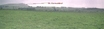 Sw6a Landscape |
Soil Profile Morphology:
Surface Soil
| A11 | 0-10 cm | Very dark brown (10YR2/2) fine sandy clay loam; moderate medium blocky, parting to moderate fine blocky structure; pH 5.9; abrupt change to: | 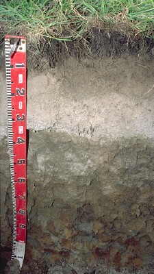 SW6a Profile |
| A21 | 10-20 cm | Brown (10YR4/3) fine sandy clay loam; rusty root channel mottling; weak to moderate medium-coarse blocky structure; weak consistence moist; pH 5.6; abrupt change to: | |
| A22 | 20-40 cm | Brown (10YR5/3) conspicuously bleached (10YR7/2d); fine sandy loam; contains many (40-50%) ferruginous nodules (2-10 mm size) and some vesicular 'bombs' up to 120 mm size; pH 6.1; abrupt change to: | |
| Subsoil | |||
| B21 | 40-80 cm | Brown (10YR5/3) with yellowish brown (10YR5/8) and slight red (2.5YR4/8) mottles; medium clay; weak to moderate very coarse prismatic, parting to moderate coarse blocky to moderate medium blocky structure; pH 5.2; clear change to: | |
| B22 | 80-110 cm | Light brownish grey (10YR6/2) with brownish yellow (10YR6/6) mottles; light medium clay; moderate coarse blocky; firm consistence slightly moist; pH 5.7. |
Key Profile Features:
- Very strong texture contrast between surface (A) horizons (< 20% clay) and the subsoil (B21) horizon (80 % clay).
- Thick conspicuously bleached subsurface (A2) horizon.
Soil Profile Characteristics:
- | pH | Salinity | ||
Surface Soil (A21 horizon) | Moderately Acid | High | Non-Sodic | - |
Subsoil (40-80 cm) | Strongly Acid | Low | Non-Sodic | None |
Deeper Subsoil (80-110 cm) | Moderately Acid | Low | Non-Sodic | None |
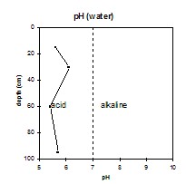 | 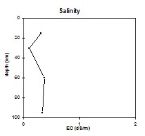 | 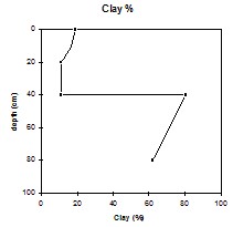 | |
| The surface horizons are mainly moderately acid. The upper subsoil is strongly acid and the deeper subsoil is moderately acid. | The salinity rating is medium to high in the surface (A) horizons and becomes low in the subsoil. | The clay percentage increases sharply at the A/B horizon interface. |
Chemical and Physical Analysis:
Horizon | Horizon Depth (cm) | pH (water) | pH (CaCl2) | EC dS/m | NaCl | Exchangeable Aluminium ppm | Exchangeable Cations | Coarse Sand (0.2-2.0 mm) % | Fine Sand (0.02-0.2 mm) % | Silt (0.002-0.02 mm) % | Clay (<0.002 mm) % | Wilting Point % w/w | |||
Ca | Mg | K | Na | ||||||||||||
meq/100g | |||||||||||||||
A21 | 10-20 | 5.6 | 4.9 | 0.31 | 0.07 | 32 | 1.8 | 1.8 | 0.26 | 0.84 | 6.5 | 45.0 | 29.5 | 16.5 | 8.0 |
A22 | 20-40 | 6.1 | 5.0 | 0.10 | 0.94 | 0.96 | 0.17 | 0.34 | 26.2 | 38.3 | 24.5 | 11.0 | 5.7 | ||
B21 | 40-80 | 5.4 | 5.0 | 0.37 | 3.8 | 10 | 0.33 | 1.8 | 2.9 | 10.5 | 8.5 | 80.5 | 30.5 | ||
B22 | 80-110 | 5.7 | 5.0 | 0.34 | 6.0 | 20 | 0.22 | 3.1 | 1.8 | 16.0 | 20.5 | 62.0 | 32.2 | ||
Management Considerations:
Whole Profile
- Plant available water capacity (PAWC) is considered to be low-medium (estimated at 93 mm) for the top metre of this soil profile. This is based on available laboratory data. Effective PAWC is likely to be lower than this, however, as the subsoil is dense and coarsely structured; which will restrict root growth.
- The coarsely structured subsoil is sodic and has a low Ca:Mg ratio (ie. < 0.4). Although no dispersion occurs, root movement is likely to be restricted to some degree by the coarse structure.
Profile Described By: Mark Imhof, Austin Brown and Ruth Lourey, 16th April 1996.
© State of Victoria (Agriculture Victoria) 1996 - 2025.

This work, Victorian Resources Online, is licensed under a Creative Commons Attribution 4.0 licence. You are free to re-use the work under that licence, on the condition that you credit the State of Victoria (Agriculture Victoria) as author, indicate if changes were made and comply with the other licence terms.
The licence does not apply to ‘branding’ or some ‘images or photographs’ that may be owned by third parties. We ask you to seek prior approval to use images using the VRO feedback form. Access to higher quality images can also be provided on request.
This page was last updated on 23/03/2020.