
SW10
Location: Grassmere
Australian Soil Classification: Melanic-Vertic, Eutrophic, Black DERMOSOL/Vertic Sodosol
Northcote Factual Key: Gn 3.42
Great Soil Group: Chernozem
General Landscape Description: Rolling hills
Site Description: Upper slope (10%) of a rolling hill.
Land Unit:
Geology: Quaternary volcanic ash deposits (Qvs), overlying Tertiary Port Campbell Limestone (Tmc).
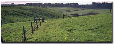 Site SW10 Landscape |
Soil Profile Morphology:
Surface Soil
| A1 | 0-20 cm | Very dark brown (7.5YR2/2) heavy clay loam; moderate coarse blocky, parting to moderate medium blocky structure; weak consistence moderately moist; pH 6.1; clear to gradual change to: | 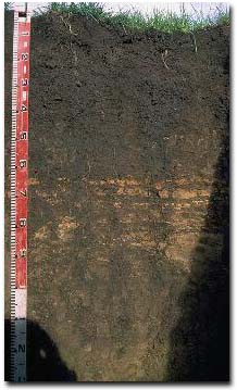 Site SW10 Profile |
| Subsoil | |||
| B21 | 20-40 cm | Very dark greyish brown (10YR3/2) light medium clay; strong medium polyhedral, parting to strong fine polyhedral structure (shiny faced peds); firm consistence moist; contains very few (2%) limestone fragments (10 mm size); pH 6.0; gradual change to: | |
| B22 | 40-60 cm | Dark brown (7.5YR3/2) medium clay; strong medium polyhedral, parting to strong fine polyhedral structure; firm consistence moist; pH 6.6; wavy change to: | |
| B23 | 60-120 cm | Dark brown (7.5YR3/2) with yellowish brown (10YR5/4) mottles; light clay; moderate medium polyhedral, parting to moderate fine polyhedral structure; strong consistence moderately moist; contains many (40%) ferruginous nodules (5-15 mm); variable yellowish brown (10YR5/4) weathered ash layer ('wombat rock'); pH 6.9; clear change to: | |
| B3 | 120-150 cm | Yellowish brown (10YR5/6) medium clay; strong fine lenticular, parting to strong very fine lenticular structure; weak consistence moderately moist; pH 7.1; abrupt change to: | |
| C | 150 cm+ | Limestone. | |
Key Profile Features:
- Gradual increase in clay content with depth in the upper soil profile.
- The upper soil profile has developed on volcanic ash deposits. It overlies an older land surface (with Vertic Sodosol soil) which developed on Tertiary limestone deposits at 120 cm depth.
Soil Profile Characteristics:
- | pH | Salinity | |
Surface Soil (A1 horizon) | Slightly Acid | Medium | Non-Sodic |
Subsoil (20-40 cm) | Moderately Acid | Medium | Non-Sodic |
Deeper Subsoil (120-150 cm) | Slightly Alkaline | Low | Sodic |
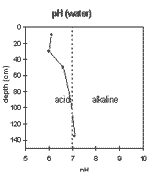 | 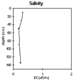 | 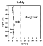 | 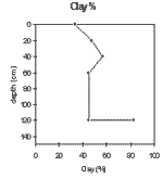 |
| The surface soil is slightly acid. The upper subsoil is moderately acid and the deeper subsoil becomes slightly acid. | The salinity rating is medium in the surface and upper subsoil and low in the deeper subsoil. | The surface is non-sodic becoming sodic at 40 cm depth. | The clay percentage increases gradually with depth in the upper part of the soil profile. In the deep subsoil the clay percentage increases sharply at the junction of an older land surface at 120 cm depth. |
Chemical and Physical Analysis:
Horizon | Horizon Depth (cm) | pH (water) | pH (CaCl2) | EC dS/m | NaCl % | Exchangeable Cations | Coarse Sand (0.2-2.0 mm) % | Fine Sand (0.02-0.2 mm) % | Silt (0.002-0.02 mm) % | Clay (<0.002 mm) % | Wilting Point % w/w | |||
Ca | Mg | K | Na | |||||||||||
meq/100g | ||||||||||||||
A1 | 0-20 | 6.1 | 5.4 | 0.32 | <0.05 | 19 | 8.9 | 1.2 | 1.6 | 5 | 25 | 21 | 33 | 26 |
B21 | 20-40 | 6.0 | 5.3 | 0.27 | <0.05 | 18 | 12 | 0.8 | 1.8 | 4 | 21 | 15 | 48 | 29 |
B22 | 40-60 | 6.6 | 5.6 | 0.19 | 19 | 21 | 0.7 | 2.7 | 2 | 14 | 14 | 57 | 39 | |
B23 | 60-120 | 6.9 | 5.9 | 0.2 | 20 | 22 | 0.6 | 3.3 | 3 | 21 | 18 | 45 | 39 | |
B3 | 120-150 | 7.1 | 6.3 | 0.25 | <0.05 | 17 | 17 | 0.5 | 2 | 1 | 8 | 4 | 83 | |
Management Considerations:
Whole Profile
- Plant available water capacity (PAWC) is considered to be medium (estimated at 110 mm) for the top metre of the soil profile. This is based on available laboratory data and uses a model developed by DNR, Qld. Effective rooting depth may be restricted by the weathered ash deposits below 60 cm depth which would result in reduced PAWC.
Surface (A) Horizon
- The nutrient status (base on the sum of the exchangeable basic cations) of the surface soil is very high.
- The surface soil has a very high wilting point value (i.e. 26%). This indicates that plants will be unable to utilise light rains falling when the soil is relatively dry.
- Due to the reasonably high clay content in the surface horizon, excessive cultivation or trafficking when the soil is moist may result in soil compaction developing. Cultivation or heavy trafficking should be avoided when the soil is wetter than the plastic limit.
- The upper subsoil is marginally sodic. Dispersion does not occur (unless the soil is remoulded) and permeability is likely to be good due to the well developed soil structure i.e. strong medium polyhedral parting to strong fine polyhedral peds.
- The nutrient status (based on the sum of the exchangeable basic cations) of the upper subsoil is very high.
- Root and water movement may be restricted to some degree by the weathered ash deposits in the deeper subsoil i.e. from 60 cm depth.
- Lucerne has grown here.
- Paddock has been ploughed.
© State of Victoria (Agriculture Victoria) 1996 - 2025.

This work, Victorian Resources Online, is licensed under a Creative Commons Attribution 4.0 licence. You are free to re-use the work under that licence, on the condition that you credit the State of Victoria (Agriculture Victoria) as author, indicate if changes were made and comply with the other licence terms.
The licence does not apply to ‘branding’ or some ‘images or photographs’ that may be owned by third parties. We ask you to seek prior approval to use images using the VRO feedback form. Access to higher quality images can also be provided on request.
This page was last updated on 23/03/2020.