
SW1
Location: Illowa
Australian Soil Classification: Melanic-Sodic, Eutrophic, Black DERMOSOL
Northcote Factual Key: Gn 3.42
Great Soil Group: Chernozem
General Landscape Description: Edge of gently undulating plain below lower slope of gently undulating rises.
Geology: Quaternary volcanic ash deposits (Qvs) overlying Tertiary Port Campbell Limestone.
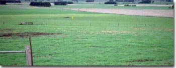
Site SW1 Landscape
Soil Profile Morphology
Surface
| A11 | 0-20 cm | Very dark brown (10YR2/2) clay loam; strong medium polyhedral, parting to strong fine polyhedral structure; very weak consistence moist; pH 7.3; gradual change to: | 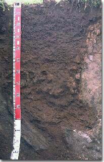 Site SW1 Profile |
| A12 | 20-40 cm | Very dark brown (10YR2/2) heavy clay loam; moderate medium blocky, parting to strong fine blocky structure; very weak consistence moist; pH 7.4; gradual change to: | |
| Subsoil | |||
| B21 | 40-50 cm | Very dark greyish brown (10YR3/2) heavy clay loam; strong medium polyhedral, parting to strong fine polyhedral structure; weak consistence moist; pH 7.5: clear change to: | |
| B22 | 50-60 cm | Very dark greyish brown (10YR3/2) (becoming dark brown (10YR3/3) with depth) light clay; weak consistence moist; pH 7.6; sharp change to: | |
| B23 | 60-75 cm | Discontinuous ash ('wombat rock') deposits; pH 7.7: | |
| B3 | 75-90 cm | Dark yellowish brown (10YR4/4) sandy clay loam; weak coarse blocky, parting to weak medium blocky structure; weak consistence moist; pH 7.7; wavy change to: | |
| C | 90 cm+ | Ash deposits. | |
Soil Profile Characteristics:
- | pH | Salinity | |
Surface Soil (A1 horizon) | Slightly Alkaline | Medium | Sodic |
Subsoil (B21 Horizon) | Slightly Alkaline | Medium | Sodic |
Deeper Subsoil (75-90 cm) | Slightly Alkaline | Medium | Sodic |
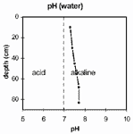 | [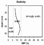 | 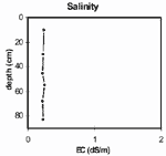 | 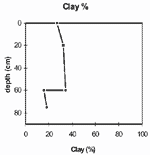 |
| The soil profile is slightly alkaline throughout. | The soil profile is sodic throughout. | The salinity rating is medium throughout the soil profile. | The clay percentage increases gradually with depth in the upper part of the soil profile. |
Chemical and Physical Analysis:
Horizon | Horizon Depth (cm) | pH (water) | pH (CaCl2) | EC dS/m | Exchangeable Cations | Coarse Sand (0.2-2.0 mm) % | Fine Sand (0.02-0.2 mm) % | Silt (0.002-0.02 mm) % | Clay (<0.002 mm) % | Wilting Point % w/w | |||
Ca | Mg | K | Na | ||||||||||
meq/100g | |||||||||||||
A11 | 0-20 | 7.3 | 6.6 | 0.24 | 23 | 12 | 0.6 | 2.8 | 7 | 22 | 26 | 27 | 28 |
A12 | 20-40 | 7.4 | 6.5 | 0.23 | 18 | 14 | 0.4 | 2.9 | 7 | 23 | 25 | 33 | 24 |
B21 | 40-50 | 7.5 | 6.6 | 0.22 | 17 | 16 | 0.4 | 4.1 | 7 | 28 | 21 | 32 | 24 |
B22 | 50-60 | 7.6 | 6.6 | 0.25 | 18 | 17 | 0.4 | 4.9 | 7 | 26 | 20 | 35 | 25 |
B23 | 60-75 | 7.7 | 6.5 | 0.22 | 19 | 17 | 0.3 | 5.6 | 25 | 32 | 15 | 16 | |
B3 | 75-90 | 7.7 | 6.7 | 0.23 | 26 | 18 | 0.4 | 6 | 13 | 35 | 22 | 18 | |
Key Profile Features:
- Negligible texture contrast between surface (A) horizons and the upper subsoil (B21) horizon.
- Presence of discontinuous areas of weathered ash deposits ('wombat rock') throughout profile.
| The soil profile is slightly alkaline throughout. | | The salinity rating is very low throughout the soil profile. |
| The soil profile is sodic throughout. Strong to complete dispersion of the subsoil occurs only after remoulding. | | The clay percentage increases gradually with depth in the upper part of the soil profile. |
Profile Described By: Mark Imhof, Austin Brown and Ruth Lourey, 15th April 1996.
© State of Victoria (Agriculture Victoria) 1996 - 2025.

This work, Victorian Resources Online, is licensed under a Creative Commons Attribution 4.0 licence. You are free to re-use the work under that licence, on the condition that you credit the State of Victoria (Agriculture Victoria) as author, indicate if changes were made and comply with the other licence terms.
The licence does not apply to ‘branding’ or some ‘images or photographs’ that may be owned by third parties. We ask you to seek prior approval to use images using the VRO feedback form. Access to higher quality images can also be provided on request.
This page was last updated on 23/03/2020.