
Site GL168
Land Mapping Unit: Ararat Granites
Australian Soil Classification: Mesotrophic, Mottled-Mesonatric, Grey SODOSOL (confidence level 1).
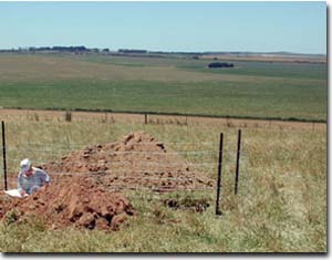 Site GL168 Landscape. |
General Land Unit Description:
This land unit consists of granitic hills and rises around Ararat. Granitic tors are common on the crests and at the break of slope in some areas. Landslips are evident on the steeper slopes. This site is on a long slope off a rocky crest (GL167). Granite rock outcrop is common at the break-of-slope, although it is generally absent on the slope. The soils are deeper than at site GL167, although there is still a deep C horizon present. Soil depth is variable. The C horizon tends to act as a barrier for water penetration. The deeper clay subsoil horizon has an intermittent gleyed appearance that supports this. The prismatic and coarse angular structure of the subsoil is typical of strongly sodic subsoils. The dominant soil type is a Grey Sodosol, often found on the lower slopes, similar to this site. Chromosols are more likely to occur on the crests and steeper slopes. The steeper slopes and rocky crests would have a lower capability of supporting land use due to land and soil limitations.
Site Description:
Slope: 6%
Geology: Ordovician Granite.
Landform pattern: Low Hills.
Position in landscape: Lower slope.
Internal drainage: Well drained.
Soil Profile Morphology:
Surface Soil
| A1 | 0-10 cm | Dark brown (7.5YR3/3); loamy coarse sand; weak medium polyhedral structure; very weak consistence (dry); a few small angular pebbles (2-6 mm); pH 5.4; gradual change to: | 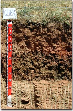 Site GL168 Profile. |
| A21 | 10-30cm | Brown (7.5YR4/4); loamy coarse sand; massive; weak consistence (dry); pH 5.2; gradual change to: | |
| A22 | 30-40cm | Brown (7.5YR5/4); loamy coarse sand; conspicuously bleached (7.5YR7/4); when dry; massive; weak consistence (dry); pH 5.9; clear change to: | |
| Subsoil | |||
| B21 | 40-55 cm | Brown (10YR4/2); heavy clay; many prominent fine dark red (2.5YR3/6) mottles; strong coarse prismatic; parting to strong very fine angular blocky structure; clay skins common; pH 7.4; clear and wavy change to: | |
| B22 | 55-80 cm | Weak red (10R5/3); heavy clay; prominent brownish yellow (10YR6/6) mottles common; strong coarse prismatic structure; very few fine manganiferous flecks; clay skins common; pH 7.9; sharp change of variable depth to: | |
| C | 80-180+ cm | Weathered granite. | |
Key Profile Features:
- Strong texture contrast between surface (A) horizons and subsoil (B) horizons.
- Sandy surface (A) horizons.
- Conspicuously bleached subsurface (A2) horizons.
Soil Profile Characteristics:
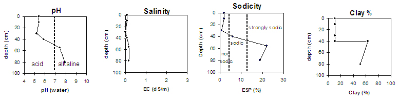
pH | Salinity Rating | |||
Surface (A1 horizon) | Strongly Acid | Low | Non-Sodic | None |
Subsoil (40-55 cm) | Slightly Alkaline | Low | Strongly Sodic | None1 |
Deeper Subsoil (55-80 cm) | Slightly Alkaline | Low | Strongly Sodic | Strong to Complete |
 |
Horizon | Horizon Depth (cm) | pH (water) | pH (CaCl2) | EC 1:5 | Exchangeable Aluminium mg/kg | Exchangeable Acidity meq/100g | Exchangeable Cations | |||
Ca | Mg | K | Na | |||||||
meq/100g | ||||||||||
A1 | 0-10 | 5.4 | 4.4 | 0.08 | 17 | 7 | 1.8 | 0.42 | 0.58 | 0.25 |
A21 | 10-30 | 5.2 | 4.5 | <0.05 | 25 | 3.9 | 0.77 | 0.31 | 0.18 | 0.08 |
A22 | 30-40 | 5.9 | 5.1 | 0.07 | <10 | 2.8 | 0.94 | 0.54 | 0.19 | 0.28 |
B21 | 40-55 | 7.4 | 6.2 | 0.16 | 5.2 | 7.2 | 0.94 | 3.8 | ||
B22 | 55-80 | 7.9 | 6.8 | 0.16 | 6.1 | 9.8 | 0.86 | 4 | ||
Horizon | Horizon Depth (cm) | Field Capacity pF2.5 | Wilting Point pF4.2 | Coarse Sand (0.2- 2.0 mm) | Fine Sand (0.02- 0.2 mm) | Silt (0.002- 0.02 mm) | Clay (<0.002 mm) |
A1 | 0-10 | 12 | 4 | 38 | 38 | 12 | 11 |
A21 | 10-30 | 11 | 4 | 42 | 35 | 12 | 10 |
A22 | 30-40 | 12 | 3 | 36 | 39 | 15 | 10 |
B21 | 40-55 | 39 | 23 | 11 | 18 | 7 | 63 |
B22 | 55-80 | 41 | 19 | 17 | 19 | 11 | 51 |
Profile Described By: Natalie Baxter, Nathan Robinson, Grant Boyle and Mark Imhof (October 2001).
© State of Victoria (Agriculture Victoria) 1996 - .

This work, Victorian Resources Online, is licensed under a Creative Commons Attribution 4.0 licence. You are free to re-use the work under that licence, on the condition that you credit the State of Victoria (Agriculture Victoria) as author, indicate if changes were made and comply with the other licence terms.
The licence does not apply to ‘branding’ or some ‘images or photographs’ that may be owned by third parties. We ask you to seek prior approval to use images using the VRO feedback form. Access to higher quality images can also be provided on request.
This page was last updated on .