
MM754
| Site: MM754 | Land Unit: Warrabkook Basalts |
| Aust. Soil Class.: Ferric, Mottled-Subnatric, Brown SODOSOL (confidence level 3) | |
| General Land Unit Description: This land unit consists of gently undulating basalt plains in the Macarthur area. In some drainage lines, the basalt has been dissected sufficiently to expose the underlying sediments. The soils on the basalt plains are commonly Brown Kurosols or Chormosols, intermixed with Sodosols, particularly on the lower slopes and drainage depressions. |
Site Description:
| Geology: Quaternary basalt | Landform pattern: Undulating plain |
| Position in landscape: Mid to lower slope | Internal drainage: Imperfectly drained |
Soil Profile Morphology
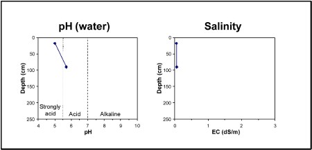
| A11 | 0-35 cm | Very dark greyish brown (10YR3/1) loamy sand, apedal structure (single grain), pH 5.0. Gradational transition to: |
| A12 | 35-70 cm | Brown (10YR4/3) sandy loam. Gradational transition to: |
| A2 | 70-90 cm | Pale brown (10YR6/3) sandy loam, conspicuously bleached (10YR7/2) when dry, ferromanganiferous nodules are abundant. Sharp transition to: |
| Subsoil | ||
| B21 | 90+ cm | Yellowish brown (10YR5/4), heavy clay, yellowish brown mottles, pH 5.7. |
Key profile features:
- Acidic topsoil
- Ferromanganiferious nodules are abundant in A2 horizon
- Sodic subsoil
- Strong texture contrast between topsoil and subsoil
- Bleached A2 horizn
- Mottled subsoil
© State of Victoria (Agriculture Victoria) 1996 - 2025.

This work, Victorian Resources Online, is licensed under a Creative Commons Attribution 4.0 licence. You are free to re-use the work under that licence, on the condition that you credit the State of Victoria (Agriculture Victoria) as author, indicate if changes were made and comply with the other licence terms.
The licence does not apply to ‘branding’ or some ‘images or photographs’ that may be owned by third parties. We ask you to seek prior approval to use images using the VRO feedback form. Access to higher quality images can also be provided on request.
This page was last updated on 23/03/2020.