MM607
| Site: MM607 | Land Unit: Chatsworth Basalts |
| Aust. Soil Class.: Ferric, Mottled-Subnatric, Black SODOSOL (confidence level 3) | |
| General Land Unit Description: This land unit consists of the dissected level to gently undulating plains stretching from Hamilton to Streatham. The land unit consists of areas of flats, stony rises and swamps or depressions. Ferric Sodosols are the dominant soil type, although the subsoil colour changes depending on the position of the landscape, with Black Sodosols on the broader plains, Brown Sodosols on the slopes and Grey Sodosols on the depressions. On the gentler rises, which generally lack any surface stones or boulders, the soils have mainly sporadic bleached subsurface horizons although those with a conspicuously bleached subsurface horizon may also occur but are less common. Although the shallow phases occur throughout the unit they are more commonly found on the steeper rises with scattered surface boulders and stones. The sub-dominant soils of these stonier rises are Black Chromosols. On the rises with many surface stones and boulders, which are mainly concentrated on upper slopes and crests, the soils are dominantly the shallow phase and shallow friable Dermosols. Cracking grey clays (Vertosols) occur on the flats between the steeper rises and in the numerous swamps and depressions that are scattered throughout the unit. Gigai patches commonly occur on these plains with Sodosols occurring on both the mounds and depressions. In the Hamilton area around Lake Linlithgow, Black Selfmulching Vertosols occur on some banks and are highly prized because of their productivity. |
Site Description:
| Geology: Quaternary basalt | Landform pattern: Level to gently undulating plains |
| Position in landscape: Mid slope | Internal drainage: Imperfectly drained |
Soil Profile Morphology
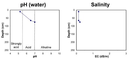
| A1 | 0-20 cm | Very dark greyish brown (10YR3/2) clay loam, hard-setting surface, pH 5.2, clear transition to: |
| A2 | 20-55 cm | Clay loam sporadically bleached (10YR7/2) when dry, ferromanganiferous nodules are abundant, sharp transition to: |
| Subsoil | ||
| B21 | 55-75 cm | Yellowish brown (10YR3/2) heavy clay, yellowish brown mottles, moderate blocky structure (10-20 mm), pH 6.5, gradual transition to: |
| B22 | 75+ cm | Yellowish brown (10YR5/6) medium clay, red mottles, moderate blocky structure (10-20 mm), pH 7.0. |
Key profile features:
- Strongly acidic topsoil
- Bleached A2 horizon
- Strong texture contrast between topsoil and subsoil
- Mottled subsoil
- Ferromanganiferious nodules are abundant in A2 horizon
- Sodic subsoil
- Topsoil dispersive when worked when wet


