
SM04
Location: Gatum
Australian Soil Classification: Ferric-Sodic, Eutrophic, Brown CHROMOSOL
General Landscape Description: Undulating dissected peneplain.
Site Description: Rise crest.
Land Use: Grazing.
Geology: Neogene sediments.
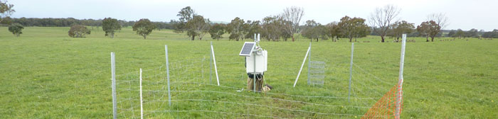
SM04 Landscape
Soil Profile Morphology:
| Surface Soil | 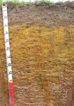 SM04 Profile | ||
| A11 | 0-13 cm | Very dark grey (10YR3/1); firm surface condition; loam (fine sandy); moderate medium polyhedral, parting to fine polyhedral structure; rough fabric; medium roots abundant; pH 5.5; abrupt and wavy change to: | |
| A12 | 13-27 cm | Dark greyish brown (10YR4/2), sporadically bleach; fine sandy loam; moderate medium polyhedral, parting to moderate fine polyhedral structure; rough fabric; weak consistence moderately moist; many gravelly ferruginous nodules; many medium roots present; pH 5.5; abrupt and wavy change to: | |
| Subsoil | |||
| B21 | 27-45 cm | Light olive brown (2.5Y5/6) with faint strong brown (7.5YR4/6) mottles common; medium clay; moderate coarse polyhedral, parting to strong fine polyhedral structure; smooth to rough fabric; firm consistence moderately moist; contains few gravelly ferruginous nodules; few medium and fine roots present; pH 6.1; gradual change to: | |
| B22 | 45-75 cm | Light olive brown (2.5Y5/6) with distinct dark greyish brown (10YR4/2) mottles common; medium clay; moderate coarse polyhedral, parting to moderate fine polyhedral structure; smooth fabric; firm consistence moderately moist; contains few gravelly ferruginous nodules; few fine and very fine roots present; pH 7.0; clear change to: | |
| C1 | 75-110 cm | Light grey (2.5Y7/1) with many prominent yellowish red (5YR4/6) mottles; medium clay, fine sandy; massive; earthy fabric; firm consistence moderately moist; many gravelly ferruginous nodules; few very fine roots present; pH 5.3; gradual change to: | |
| C2 | 110-150+ cm | Yellowish red (5YR4/6) with many prominent light grey (2.5Y7/1) mottles; light medium clay (fine sandy); massive; earthy fabric; firm consistence moderately moist; many gravelly ferruginous nodules; few very fine roots present; pH 6.3. | |
pH | Salinity Rating | |||
Surface (A1 horizon) | Strongly Acid | Medium | Non-Sodic | None |
Subsoil (B21 horizon) | Slightly Acid | Very Low | Non-Sodic | None |
Deeper Subsoil (at 75-110+ cm) | Strongly Acid | Very Low | Sodic | None |
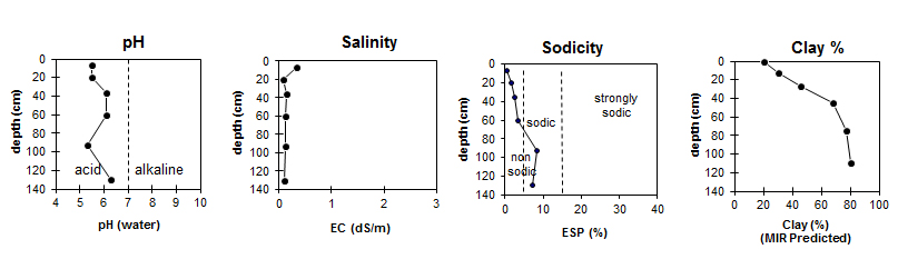
| The surface soil is strongly acid. The upper subsoil is slightly acid becoming strongly acid with depth. |
| The surface and upper subsoil is non-sodic. The deeper subsoil is sodic. | The MIR predicted clay levels are quite high in this profile. |
Horizon | Horizon Depth (cm) | pH (water) | pH (CaCl2) | EC dS/m | Exchangeable Acidity meq/100g | Total Carbon g/100g | Exchangeable Aluminium mg/kg | Exchangeable Cations | |||
Ca | Mg | K | Na | ||||||||
meq/100g | |||||||||||
A1 | 0-13 | 5.5 | 4.7 | 0.34 | 14 | 5.3 | <10 | 4.1 | 1.6 | 1.7 | 0.1 |
A2 | 13-27 | 5.5 | 4.6 | 0.08 | 9 | 2.3 | 1.1 | 0.6 | 0.2 | ||
B21 | 27-45 | 6.1 | 5.5 | 0.15 | 10 | 5.1 | 4.0 | 1.1 | 0.5 | ||
B22 | 45-75 | 7.0 | 6.2 | 0.11 | 5.6 | 6.4 | 0.2 | 0.8 | |||
C1 | 75-110 | 5.3 | 4.5 | 0.10 | 2.2 | 6.1 | 0.1 | 0.8 | |||
C2 | 110-150+ | 6.3 | 5.7 | 0.10 | 4.0 | 7.1 | 0.1 | 0.9 | |||
Horizon | Horizon Depth (cm) | Field Capacity pF2.5 (MIR Predicted) | Wilting Point pF4.2 (MIR Predicted) | Coarse Sand (0.2-2.0mm) (MIR Predicted) | Fine Sand (0.02-0.2mm) (MIR Predicted) | Silt (0.002-0.02mm) (MIR Predicted) | Clay (<0.002mm) (MIR Predicted) |
A1 | 0-13 | 24.8 | 11.9 | 20 | 33 | 14 | 20 |
A2 | 13-27 | 24.2 | 10.8 | 14 | 30 | 14 | 30 |
B21 | 27-45 | 30.4 | 17.2 | 14 | 23 | 8 | 46 |
B22 | 45-75 | 31.0 | 22.0 | 8 | 17 | 8 | 68 |
C1 | 75-110 | 33.4 | 23.5 | 6 | 13 | 6 | 77 |
C2 | 110-150+ | 34.7 | 25.3 | 6 | 13 | 5 | 80 |
Profile Described By: David Rees and Ivanah Oliver (September 2014).
© State of Victoria (Agriculture Victoria) 1996 - 2025.

This work, Victorian Resources Online, is licensed under a Creative Commons Attribution 4.0 licence. You are free to re-use the work under that licence, on the condition that you credit the State of Victoria (Agriculture Victoria) as author, indicate if changes were made and comply with the other licence terms.
The licence does not apply to ‘branding’ or some ‘images or photographs’ that may be owned by third parties. We ask you to seek prior approval to use images using the VRO feedback form. Access to higher quality images can also be provided on request.
This page was last updated on 23/03/2020.