
SFS6
Location: Cardigan
Australian Soil Classification: Vertic (& Ferric), Mottled-Mesonatric, Yellow SODOSOL
General Landscape Description: Plain within the Victorian volcanic plains.
Site Description: Slope with gilgai microrelief. Profile description midway down gilgai hollow.
Land Use: Raised bed cropping.
Soil Type: Similar to SFS5a & SFS5b.
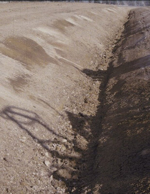 |   SFS6 Profile. Measuring tape shows the gilgai across the profile face over a 3 m width, rather than the depth of the profile. | |
|
Soil Profile Morphology:
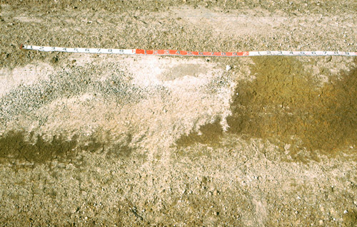
| Surface Soil |  SFS6 Soil surface. | ||
| Ap | 0 – 15 cm | Surface is weak and powdery with a surface seal, >10 % of surface has exposed coarse buckshot where <10 % is magnetic; brown (10YR4/3); fine sandy clay loam; apedal; firm consistence dry; pH 5.7; clear change to: | |
| A2c | 15 – 40/45 cm | Pale brown (10YR6/3) conspicuously bleached (10YR7/3 dry); light fine sandy clay loam; apedal; abundant (~50 %) medium (5-25 mm) buckshot gravel that is hard but can be broken with some finger force having black manganiferous centres becoming cemented at base of horizon; pH 5.4; clear change to: | |
| Subsoil | |||
| B1c | 40/45 – 60 cm | Fine sandy clay loam; abundant (~80 %) medium to coarse (10-40 mm) manganiferous buckshot/ironstone gravel; pH 6.7; abrupt change to: | |
| B21tg | 60 – 120+ cm | Light yellowish brown (2.5Y6/4) with prominent small linear dark red (2.5YR4/8) mottles with a brownish yellow (10YR6/8) fringe; light medium clay; fine (5-10 mm) polyhedral structure; pH 7.2. | |
Key Profile Features:
- Lateral variation in soil horizons due to gilgai microrelief (e.g. variations in subsurface A1 horizon thickness).
Soil Profile Characteristics:
pH | Salinity Rating | |||
Surface (A1 horizon) | Moderately Acid | Low | Non-Sodic | None |
Subsoil (B21 horizon higher) | Neutral | Very Low | Sodic | None |
Deeper Subsoil (B21 horizon lower) | Slightly Alkaline | Low | Sodic | None |
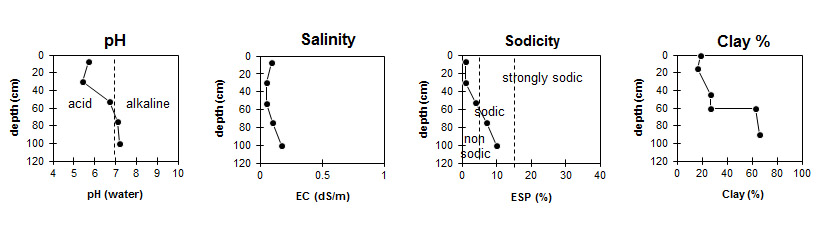
Horizon | Horizon Depth (cm) | pH (water) | pH (CaCl2) | EC dS/m | Organic Carbon % | Nitrogen % | Exchangeable Cations | |||
Ca | Mg | K | Na | |||||||
meq/100g | ||||||||||
Ap | 0-15 | 5.7 | 4.9 | 0.09 | 1.2 | 0.11 | 3.1 | 0.81 | 0.38 | 0.14 |
A2 | 15-40/45 | 5.4 | 4.6 | <0.05 | 1.9 | 0.51 | 0.17 | 0.08 | ||
B1 | 40/45-60 | 6.7 | 5.7 | 0.05 | 2.1 | 2.6 | 0.17 | 0.51 | ||
B21 (Higher) | 60-90 | 7.0 | 6.0 | 0.1 | 3.6 | 8.2 | 0.29 | 1.7 | ||
B21 (Lower) | 90-120 | 7.2 | 6.3 | 0.17 | 3.9 | 10 | 0.35 | 2.6 | ||
Horizon | Horizon Depth (cm) | Exchangeable Aluminium mg/kg | Exchangeable Acidity meq/100g | Field Capacity pF2.5 | Wilting Point pF4.2 | Coarse Sand (0.2-2.0 mm) | Fine Sand (0.02-0.2 mm) | Silt (0.002-0.02 mm) | Clay (<0.002 mm) |
Ap | 0-15 | <10 | 6.9 | 29 | 7.0 | 4 | 46 | 25 | 19 |
A2 | 15-40/45 | 18 | 6.5 | 27.9 | 18.5 | 8 | 46 | 25 | 16 |
B1 | 40/45-60 | 6.3 | 27.3 | 9.9 | 11 | 39 | 20 | 27 | |
B21 (Higher) | 60-90 | 9.4 | 39.0 | 22.6 | 6 | 8 | 15 | 63 | |
B21 (Lower) | 90-120 | 9.4 | 46.0 | 25.1 | 3 | 16 | 12 | 66 |
Management Considerations:
Whole Profile
- Plant available water capacity (PAWC) in the gilgai hollow is considered to be low (estimated at 88 mm) in the upper 100 cm of this soil profile.
© State of Victoria (Agriculture Victoria) 1996 - 2025.

This work, Victorian Resources Online, is licensed under a Creative Commons Attribution 4.0 licence. You are free to re-use the work under that licence, on the condition that you credit the State of Victoria (Agriculture Victoria) as author, indicate if changes were made and comply with the other licence terms.
The licence does not apply to ‘branding’ or some ‘images or photographs’ that may be owned by third parties. We ask you to seek prior approval to use images using the VRO feedback form. Access to higher quality images can also be provided on request.
This page was last updated on 23/03/2020.