
SFS17
Location: Woorndoo
Australian Soil Classification: Vertic, Mottled-Hypernatric, Black and Grey SODOSOL
General Landscape Description: Gently undulating basalt plain
Site Description: Relatively elevated position near the crest with gilgai 4 m wide.
Land Use: Wheat cropping
Geology: Quaternary - Newer Volcanics
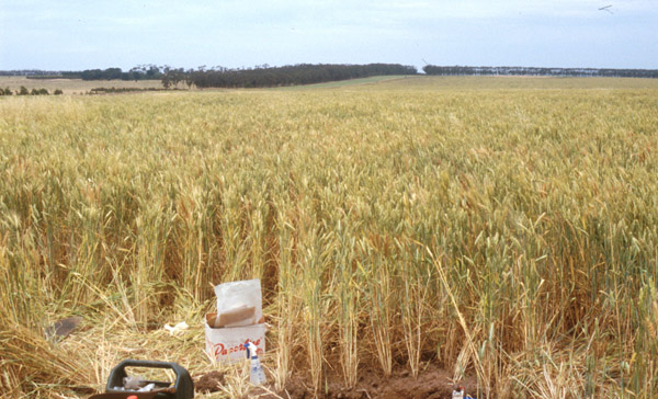
SFS17 Landscape
Soil Profile Morphology:
Surface Soil
| Ap | 0-10 cm | Brown (10YR5/3); fine sandy clay loam; cracking surface; apedal to weakly pedal; weak consistence dry; pH 5.8; abrupt change to: | 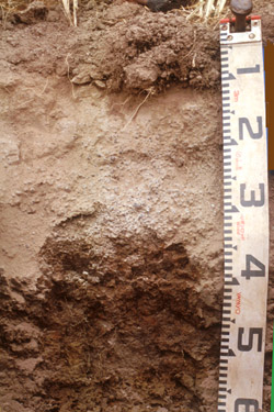 SFS17 Profile |
| A21e | 10-20 cm | Light brownish grey (10YR6/2) conspicuously bleached (10YR7/3d); fine sandy loam; apedal but with platy pan in upper part of horizon; weak to firm consistence dry; pH 5.1; clear change to: | |
| A22c | 20-35 cm | Light brownish grey (10YR6/2) conspicuously bleached (10YR7/3d); gravelly loam; very many medium to coarse (3-20 mm) buckshot (the coarser buckshot fraction is comprised of cemented smaller buckshot, the finer fraction is magnetic); pH 6.0; sharp change to: NOTE: horizon varies in thickness, can go as deep as 60 cm. | |
| Subsoil | |||
| B21t | 35-60 cm | Dark grey to very dark grey (10YR4/1 – 3/1) with fine strong red mottles (sometimes yellower and becoming dull yellow with depth); heavy clay; strong coarse prismatic, parting to medium blocky structure; strong consistence dry; pH 7.1-7.7. | |
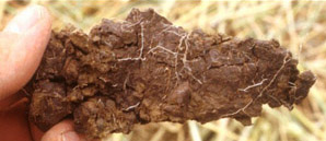 Subsoil B21 ped Subsoil B21 ped | 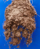 Crop root development |
Key Profile Features:
- Strong texture contrast between surface (A) horizons and subsoil (B21) horizon.
- Conspicuously bleached subsurface (A2) horizon.
Soil Profile Characteristics:
pH | Salinity Rating | |||
Surface (A1 horizon) | Moderately Acid | Low | Non-Sodic | None |
Subsoil (B21 horizon) | Near Neutral | Low | Strongly sodic | Strong-Complete |
Deeper Subsoil (at 50-60 cm) | Slightly Alkaline | Low | Strongly Sodic | Strong |
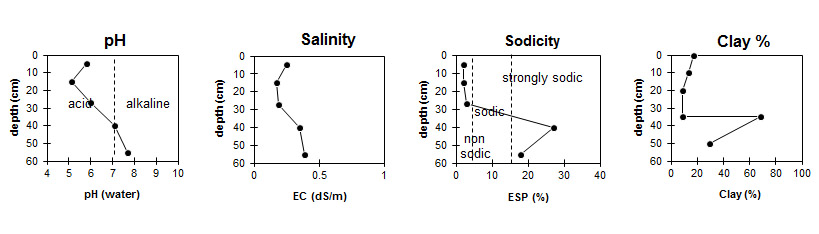
Horizon | Horizon Depth (cm) | pH (water) | pH (CaCl2) | EC dS/m | NaCl % | Organic Carbon % | Nitrogen % | Exchangeable Cations | |||
Ca | Mg | K | Na | ||||||||
meq/100g | |||||||||||
Ap | 0-10 | 5.8 | 5.8 | 0.25 | 2.9 | 0.25 | 6.5 | 1.6 | 0.31 | 0.33 | |
A21 | 10-20 | 5.1 | 4.7 | 0.17 | 1.9 | 0.66 | 0.10 | 0.12 | |||
A22 | 20-35 | 6.0 | 5.7 | 0.19 | 1.5 | 0.73 | 0.14 | 0.28 | |||
B21 (upper) | 35-45 | 7.1 | 6.3 | 0.35 | 0.04 | 5.4 | 9.0 | 0.7 | 5.6 | ||
B21 (lower) | 50-60 | 7.7 | 7.0 | 0.39 | 0.04 | 4.9 | 8.4 | 0.6 | 5.3 | ||
Horizon | Horizon Depth (cm) | Exchangeable Aluminium mg/kg | Exchangeable Acidity meq/100g | Field Capacity pF2.5 | Wilting Point pF4.2 | Coarse Sand (0.2-2.0 mm) | Fine Sand (0.02-0.2 mm) | Silt (0.002-0.02 mm) | Clay (<0.002 mm) |
Ap | 0-10 | <10 | 8.8 | 29.2 | 9.8 | 8 | 43 | 26 | 17 |
A21 | 10-20 | <10 | 4.6 | 22.4 | 4.4 | 8 | 49 | 27 | 14 |
A22 | 20-35 | <10 | 7.4 | 15.8 | 6.5 | 55 | 22 | 13 | 9 |
B21 (upper) | 35-45 | 41.2 | 26.6 | 7 | 13 | 7 | 69 | ||
B21 (lower) | 50-60 | 37.2 | 22.9 | 17 | 16 | 28 | 30 |
Management Considerations:
Whole Profile
- Plant available water capacity (PAWC) is considered to be low (estimated at 95 mm) in the upper 100 cm of this soil profile.
NOTES: Property owner reports that this paddock has crabhole features with A2 and buckshot of very variable thickness, some places the clay B horizon may be at 60 cm depth while in others the clay is almost at the surface. Generally around 4 metres between crabholes. Soil shows cracking to surface on “clay banks” and crickets are plentiful.
Profile Described By: Richard MacEwan (December 1999).
© State of Victoria (Agriculture Victoria) 1996 - 2025.

This work, Victorian Resources Online, is licensed under a Creative Commons Attribution 4.0 licence. You are free to re-use the work under that licence, on the condition that you credit the State of Victoria (Agriculture Victoria) as author, indicate if changes were made and comply with the other licence terms.
The licence does not apply to ‘branding’ or some ‘images or photographs’ that may be owned by third parties. We ask you to seek prior approval to use images using the VRO feedback form. Access to higher quality images can also be provided on request.
This page was last updated on 23/03/2020.