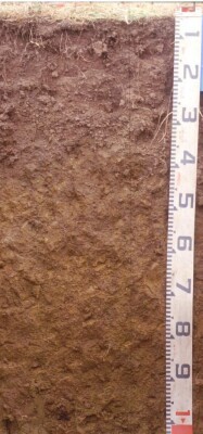
SFS15
| Site: SFS 15 | Land Unit: Monivae Basalt |
| Aust. Soil Class.: Ferric-Sodic, Eutrophic, Brown CHROMOSOL (confidence level 1) | |
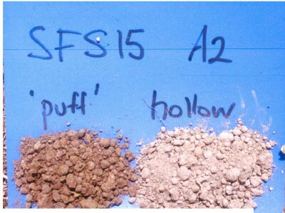
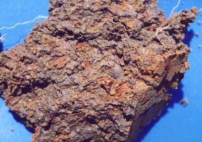
| General Land Unit Description: The level to gently undulating basalt plains between Branxholm and Glenthompson consist of an association of Vertic or Ferric Brown Chromosols and Ferric Brown Sodosols. The Chromosols typically occur on the upper slopes and crests of very slight rises that may have scattered surface boulders, and Sodosols on the lower slopes and depressions. Sodosols or Vertosols, occasionally with a sporadic bleached subsurface horizon, are usually found in open depressions or drainage lines. The soil at this site indicates the presence of gilgai microrelief. The face of pit shows features of ‘puff’, while sides and rear of pit shows features associated with ‘hollow’. The thick A2 horizon in the hollow is very high (>80%) with buckshot (3-10 mm), mostly magnetic, irregular rounded or subrounded (pitted). |
Site Description:
| Geology: Quaternary basalt | Landform pattern: Level to gently undulating plain |
| Position in landscape: Elevated plain | Internal drainage: Moderately well drained |
Soil Profile Morphology
| A1 (Ap) | 0-20 cm | Very dark greyish brown (10YR 3/2 moist), greyish brown (10YR 5/2 dry) fine sandy clay loam. weakly to moderately pedal, sub-angular blocky to polyhedral (2–25 mm), firm (dry) to weak (moist) consistence. Clear change to: |  |
| A2c | 20-35/37 cm | Very dark greyish brown (10YR 3/2 moist), (10YR 5/2 dry) to light greyish brown (10YR 6/2) dry, gravelly loam with hard magnetic ferromanganiferous concretions (3-10 mm), pH 5.6. Clear change (smooth and wavy, up to 50 cm in hollow) to: | |
| Subsoil | |||
| B21t | 35-37-100 cm | Yellowish brown (10YR 5/4) with fine yellowish brown (10YR 5/8) and brown (10YR 4/3) mottles, light medium clay, fine buckshot (>10%), pH 6.6. Clear change to: | |
| B22t (ss) | 100+ cm | Mottled (fine – medium) grey (N6/) and brownish yellow (10YR 6/8), light olive brown (2.5Y 5/3) and yellowish brown (10YR 5/8), medium heavy to heavy clay, no buckshot, horizon cracked to base of pit and fissure traceable through B21 above, stress cutans (slickensides) on ped faces, pH 6.6. |
 Puff and Hollow |  Subsoil mottling |
Key Profile Features
- Variation in soil profile features association with gilgai microrelief
- Strong texture contrast between surface (A) horizon and subsoils (B21 horizon)
Soil Profile Characteristics
pH | Salinity Rating | Sodicity | Dispersion | |
Surface soil (A1 horizon) | - | - | - | - |
Upper subsoil (B21 horizon) | Slightly Acid | Low | Non-Sodic | None |
Deeper subsoil (at 100+ cm) | Slightly Acid | Low | Sodic | None |

Horizon | Horizon Depth | pH (water) | pH CaCl2 | EC dS/m | NaCl % | Exchangeable Cations | Ex Al mg/kg | Ex Ac meq/100g | Field pF2.5 | Wilting Point pF4.2 | Coarse Sand (0.02-0.2mm) | Fine Sand (0.02-0.2mm) | Silt (0.02-0.02mm) | Clay (<0.002mm) | |||
Ca | Mg | K | Na | ||||||||||||||
meq/100g | |||||||||||||||||
A2 | 20-35 | 5.6 | 5.0 | 0.14 | 3.1 | 1.6 | 0.11 | 0.27 | <10 | 9.6 | 27.5 | 10.2 | 19.8 | 33.5 | 22.0 | 21.0 | |
B21 | 40-60 | 6.6 | 6.0 | 0.20 | 8.1 | 9.4 | 0.25 | 1.4 | 14 | 49.5 | 32.5 | 2.2 | 7.6 | 7.0 | 80.5 | ||
B21 | 60-80 | 6.7 | 6.1 | 0.18 | 6.5 | 9.1 | 0.23 | 1.7 | 14 | 48.8 | 31.1 | 3.4 | 8.7 | 6.5 | 7.8 | ||
B22 | 100+ | 6.6 | 6.0 | 0.27 | 6.5 | 12 | 0.1 | 2.7 | 13 | 3.4 | 9.0 | 11.5 | 72.5 | ||||


