
SFS10
Location: Wickliffe
Australian Soil Classification: Vertic, Mesonatric, Grey and Black SODOSOL
Landscape Description: Level plain?
Site Description:
Land Use: Barley cropping.
 SFS10 Landscape |
Soil Profile Morphology:
| Surface Soil | 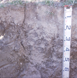 SFS10 Profile | |||
| Ap | 0-15 cm | Dark yellowish brown (10YR4/4); cracking surface condition; silty clay loam; weak fine crumb structure; weak to firm consistence dry; pH 5.5 abrupt and wavy change to: NOTE: Surface very tough to dig. Could not pick back with geopick. | ||
| A2 | 15-35 cm (where present) | Greyish brown (10YR5/2) conspicuously bleached (10YR6/1d); fine sandy clay loam; apedal; pH 6.2; gradual and broken change to: NOTE: horizon not always present. | ||
Subsoil | ||||
| B1 | 35-60 cm (where present) | Greyish brown (10YR5/2) with prominant yellowish brown (10YR5/8) mottles at frequent 5-10 mm intervals, vertical pores (2 mm) infilled with darker light brownish grey (10YR6/2) material; light medium clay; apedal; very hard consistence dry; many fine pores (<1 mm); pH 6.6; abrupt and broken change to: NOTE: horizon not always present. | ||
| B21t | 15/35-100 cm | Very dark greyish brown (2.5Y3/2) becoming olive brown (2.5Y4/3) at depth; medium clay; deep wide cracks 30-40 cm apart at 60 cm depth; extremely tough and rigid consistence, but sticky at base of cracks; pH 7.3 becoming pH 8.7 at 60-80 cm depth. | ||
| B22 | 100+ cm | |||
Key Profile Features:
- Strong texture contrast between surface (A) horizons and subsoil (B21) horizon.
- Conspicuously bleached surface (A2) horizon.
Soil Profile Characteristics:
pH | Salinity Rating | |||
Surface (A1 horizon) | Strongly Acid | Low | Non-Sodic | None |
Subsoil (B21 horizon) | Slightly Alkaline | Low | Strongly Sodic | Strong-Complete |
Deeper subsoil (at 80 cm) | Strongly Alkaline | Low-Medium | Strongly Sodic | Strong-Complete |
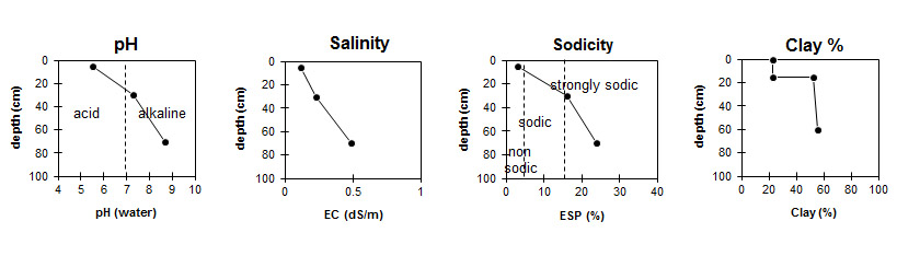
NOTE: These graphs represent the Ap horizon overlaying the B21.
Horizon | Horizon Depth (cm) | pH (water) | pH (CaCl2) | EC dS/m | NaCl % | Organic Carbon % | Nitrogen % | Exchangeable Cations | |||
Ca | Mg | K | Na | ||||||||
meq/100g | |||||||||||
Ap | 0-15 | 5.5 | 4.7 | 0.12 | 2.4 | 0.07 | 4.5 | 3 | 0.26 | 0.51 | |
A2 * | 15-35 | 6.2 | 4.7 | <0.05 | 1.6 | 1.5 | 0.15 | 0.46 | |||
B1 * | 35-60 | 6.6 | 5 | 0.08 | 2.8 | 4.6 | 0.27 | 2 | |||
B21t (higher) | 15-35 | 7.3 | 6 | 0.23 | 6.8 | 12 | 0.99 | 4.9 | |||
B21t (lower) | 60-80 | 8.7 | 7.9 | 0.49 | 0.06 | 6.8 | 14 | 1 | 7.8 | ||
Horizon | Horizon Depth (cm) | Exchangeable Aluminium mg/kg | Exchangeable Acidity meq/100g | Field Capacity pF2.5 | Wilting Point pF4.2 | Coarse Sand (0.2-2.0 mm) | Fine Sand (0.02-0.2 mm) | Silt (0.002-0.02 mm) | Clay (<0.002 mm) |
Ap | 0-15 | 58 | 10 | 25.6 | 10.8 | 7 | 43 | 23 | 23 |
A2 * | 15-35 | <10 | 4.7 | 20.9 | 6.2 | 6 | 49 | 25 | 18 |
B1 * | 35-60 | 6.9 | 26.4 | 12.3 | 6 | 41 | 21 | 30 | |
B21t (higher subsample) | 15-35 | 7 | 43.3 | 23.8 | 2 | 27 | 13 | 53 | |
B21t (lower subsample) | 60-80 | 2.8 | 44.8 | 25.4 | 3 | 24 | 15 | 56 |
Management Considerations:
Whole Profile
- Plant available water capacity (PAWC) is considered to be low (estimated at 86 mm) in the upper 70 cm of this soil profile. Effective rooting depth (ERD) is restricted to 70 cm due to the highly sodic subsoils (ESP>20).
Profile Described By: Richard MacEwan (May 1999).
© State of Victoria (Agriculture Victoria) 1996 - 2025.

This work, Victorian Resources Online, is licensed under a Creative Commons Attribution 4.0 licence. You are free to re-use the work under that licence, on the condition that you credit the State of Victoria (Agriculture Victoria) as author, indicate if changes were made and comply with the other licence terms.
The licence does not apply to ‘branding’ or some ‘images or photographs’ that may be owned by third parties. We ask you to seek prior approval to use images using the VRO feedback form. Access to higher quality images can also be provided on request.
This page was last updated on 23/03/2020.