
PVI3
Location: PVI Hamilton
Australian Soil Classification: Ferric, Eutrophic, Brown CHROMOSOL (thick, clay loamy surface)
Northcote Factual Key: DY3.42
Great Soil Group: Possibly yellow podzolic.
Geology: Tertiary/Quaternary basalt.
General Landscape Description: Mid-slope of a low rise.
Soil Mapping Unit: Monivae gravelly loam (slope phase).
Site Description: Edge of a cereal cropping paddock.
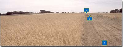 PVI3 Landscape |
Soil Profile Morphology:
Surface Soil
| A1 | 0-15 cm | Dark brown (10YR3/3); very fine sandy clay loam; weak coarse blocky structure; weak consistence (dry); pH 5.6; clear change to: | 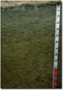 PVI3 Profile |
| A21 | 15-30 cm | Dark brown (10YR3/3); sporadically bleached; very fine sandy clay loam; firm consistence (dry); many (40%) ferruginous nodules; pH 6.3; clear change to: | |
| A22 | 30-40 cm | Clay loam (very fine sandy); massive; very firm consistence (dry); very many (60%) ferruginous nodules; pH 6.6; clear change to: | |
| Subsoil | |||
| B21 | 40-65 cm | Yellowish brown (10YR5/6) with many (40%) brownish yellow (10YR6/8) and yellowish red (5YR5/8) mottles; light medium clay; weak medium prismatic, parting to strong coarse to medium blocky structure; strong consistence (dry); very many (60%) ferruginous nodules (2-10 mm); few (5%) ferruginous basalt fragments (5-8 mm); some manganese staining; pH 6.8; gradual change to: | |
B22 | 65-120 cm | Yellowish brown (10YR5/4) with many (40%) strong brown (7.5YR5/8) and yellowish red (5YR5/8) mottles; light medium clay; weak medium prismatic, parting to strong coarse to medium to fine blocky structure; few (5%) ferruginous basalt fragments; strong consistence (dry); pH 6.5; gradual change to: | |
| B23 | 120+ cm | Yellowish brown (10YR5/4) with light grey (10YR7/1), reddish yellow (7.5YR6/8) and dark red (2.5YR4/8) mottles; medium heavy clay; firm consistence (moist); pH 6.5. | |
Key Profile Features:
- Strong texture contrast between surface (A) horizons and subsoil (B21) horizons.
- Large amount of ferruginous nodules in subsurface (A2) horizon.
pH | Salinity Rating | |||
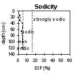
Surface Soil (A1 horizon) | Moderately Acid | Low | Non-Sodic | None |
Upper Subsoil (40 - 65 cm) | Slightly Acid | Low | Non-Sodic | None |
Deeper Subsoil (120 cm) | Slightly Acid | Low | Non-Sodic | None |
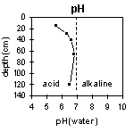 | 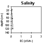 |  |  |
Horizon | Horizon Depth (cm) | pH (water) | pH (CaCl2) | EC 1:5 | Exchangeable Cations | |||
Ca | Mg | K | Na | |||||
meq/100g | ||||||||
A1 | 0-15 | 5.6 | 4.3 | 0.07 | 4.8 | 2.4 | 0.14 | 0.27 |
A2 | 15-30 | 6.3 | 5.0 | 0.06 | 3.8 | 2.6 | 0.11 | 0.37 |
A22 | 30-40 | 6.6 | 5.4 | 0.07 | 4.9 | 3.9 | 0.13 | 0.52 |
B21 | 40-65 | 6.8 | 5.7 | 0.12 | 5.5 | 6.5 | 0.22 | 1.0 |
B22 | 65-120 | 6.5 | 5.8 | 0.14 | 5.2 | 7.2 | 0.20 | 1.3 |
B23 | 120+ | 6.5 | 6.2 | 0.17 | 3.9 | 6.9 | 0.14 | 1.5 |
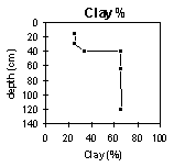
Horizon | Horizon Depth (cm) | Exchangeable Aluminium mg/kg | Exchangeable Acidity meq/100g | Field Capacity pF2.5 | Wilting Point pF4.2 | Coarse Sand (0.2- 2.0 mm) | Fine Sand (0.02- 0.2 mm) | Silt (0.002- 0.02 mm) | Clay (<0.002 mm) |
A1 | 0-15 | 12 | 35 | 13 | 4 | 40 | 26 | 25 | |
A2 | 15-30 | <10 | 28 | 11 | 14 | 37 | 20 | 26 | |
A22 | 30-40 | 27 | 13 | 20 | 28 | 15 | 34 | ||
B21 | 40-65 | 9.3 | 42 | 25 | 8 | 16 | 10 | 66 | |
B22 | 65-120 | 9.9 | 47 | 27 | 7 | 16 | 9 | 67 | |
B23 | 120+ |
Profile Described By: Mark Imhof, Paul Rampant (January /2001).
© State of Victoria (Agriculture Victoria) 1996 - 2025.

This work, Victorian Resources Online, is licensed under a Creative Commons Attribution 4.0 licence. You are free to re-use the work under that licence, on the condition that you credit the State of Victoria (Agriculture Victoria) as author, indicate if changes were made and comply with the other licence terms.
The licence does not apply to ‘branding’ or some ‘images or photographs’ that may be owned by third parties. We ask you to seek prior approval to use images using the VRO feedback form. Access to higher quality images can also be provided on request.
This page was last updated on 23/03/2020.