
LSWW25
Location: Dergholm
Australian Soil Classification: Bleached, ?, Red CHROMOSOL (confidence level 3)
General Landscape Description: Rise
Site Description: Hillslope
Land Unit: Nareen Granite
Geology: Cambrian granite
General Land Unit Description: Granite material is mainly found dissecting the Glenelg River and on the low hills and rises around Nareen. The dominant soil type is a Mottled Brown Chromosol (GL161) although this site represents variant that occurs on the better drained slopes. Due to the steep slopes, the lower slopes tend to have colluvial material deposited on top. This is the minor soil type representing the Nareen Granites land unit, occurring mainly on the dissected slopes to the Glenelg River.
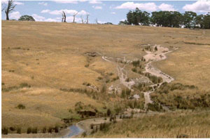
Sheet and gully erosion on granitic slopes
Soil Profile Morphology:
| Surface Soil | 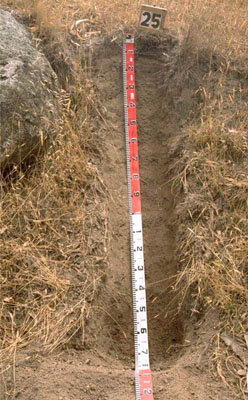 Bleached, Red Chromosol | ||
| A1 | 0-10 | Brown (7.5YR4/2); sandy loam; moderate fine subangular blocky structure; weak consistence when dry; many (30%) granitic fragments; pH 5.7; clear to abrupt boundary to: | |
| A2 | 10-140 | Brown (7.5YR4/2); sandy clay loam; conspicuously bleached; weak to massive (structureless); weak consistence when dry; many (40–50%) granitic fragments; pH 5.7. | |
| Subsoil | |||
| B2 | 140-150 | Dusky red (2.5YR4/3); medium heavy clay; polyhedral structure; smooth ped-fabric; common granitic fragments (15%); pH 5.6. | |
| C | 150-170 | Weathered granitic bedrock. |
Key Profile Features:
- Strong texture contrast between topsoil and subsoil
- Deep Bleached A2 horizon
- Acidic throughout, moderate nutrient holding capacity in subsoil likely. Limited nutrient holding capacity in surface and subsurface soil
- Thin strongly structured subsoil (Small amount of clay formation from the granite bedrock)
- Hillslope well drained site drainage. Depth to parent material may vary (rock outcrop, large boulders)
Soil Profile Characteristics:
- | pH | Salinity |
Surface Soil (A1 horizon) | Moderately Acid | Very Low |
Subsoil (140-150 cm) | Moderately Acid | Very Low |
Chemical and Physical Analysis:
Horizon | Horizon Depth (cm) | pH (water) | pH (CaCl2) | EC dS/m | Coarse Sand (0.2-2.0 mm) % | Fine Sand (0.02-0.2 mm) % | Silt (0.002-0.02 mm) % | Clay (<0.002 mm) % | Wilting Point % w/w |
A1 | 0–10 | 5.7 | 4.7 | <0.05 | 40.7 | 33.6 | 10.5 | 10.5 | 6.6 |
A2 | 10–140 | 5.7 | 4.5 | <0.05 | |||||
B2 | 140–150 | 5.6 | 4.3 | <0.05 | 26 | 18.3 | 6.5 | 44.5 | 18.3 |
C | 150–170+ |
© State of Victoria (Agriculture Victoria) 1996 - 2025.

This work, Victorian Resources Online, is licensed under a Creative Commons Attribution 4.0 licence. You are free to re-use the work under that licence, on the condition that you credit the State of Victoria (Agriculture Victoria) as author, indicate if changes were made and comply with the other licence terms.
The licence does not apply to ‘branding’ or some ‘images or photographs’ that may be owned by third parties. We ask you to seek prior approval to use images using the VRO feedback form. Access to higher quality images can also be provided on request.
This page was last updated on 23/03/2020.