
LP64
Location: Lexton
Australian Soil Classification: Vertic, Mottled-Mesonatric, Grey SODOSOL (very deep surface horizons)
General Landscape Description: Lower midslope position of a rolling low hill landscape unit.
Geology: Devonian granite.
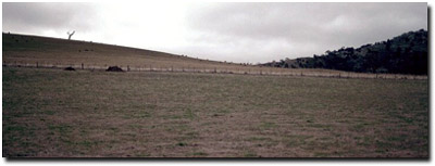 LP64 Landscape |
Soil Profile Morphology:
| Surface Soil | 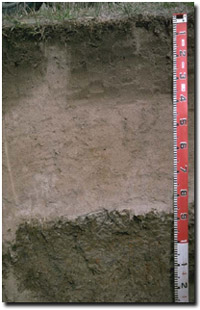 LP64 Profile | ||
| A11 | 0-30 cm | Dark brown (7.5YR3/2); light sandy clay loam; moderate very fine granular structure, becoming weak medium blocky structure with depth; pH 5.7; clear change to: | |
| A21 | 30-50 cm | Brown (10YR5/3); light very fine sandy loam; massive; firm consistence moist; pH 4.8; abrupt change to: | |
| A22 | 50-75 cm | Brown (10YR5/3) with yellow brown (10YR5/8) mottles; conspicuously bleached; light sandy clay loam; firm consistence dry; contains very few (2%) ferro-manganiferous nodules (8 mm size) and few (3%) quartz fragments; pH 6.1; abrupt change to: | |
| A23 | 75-85 cm | Greyish brown (10YR5/2); conspicuously bleached (10YR7/2d); light coarse sandy clay loam; very firm consistence dry; pH 6.6; sharp change to: | |
| Subsoil | |||
| B21 | 85-110 cm | Dark grey brown (10YR4/2) with red (2.5YR4/6) and yellow brown (10YR5/8) mottles; medium-heavy clay; very coarse prismatic structure; strong consistence moist; pH 6.9; gradual change to: | |
| B22 | 110 + cm | Greyish brown (10YR5/2) with red (2.5YR4/6) and yellow brown (10YR5/8) mottles; medium-heavy clay; strong consistence moist; quartz and gravel present in patches; slickensides present; pH 6.9. | |
Key Profile Features:
- Very thick subsurface (A2) horizons (to 85 cm depth).
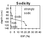
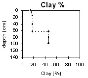
- Strong texture contrast between surface (A) horizons (<20% clay) and subsurface (B21) horizon (46% clay).
- Conspicuously bleached subsurface (A2) horizons.
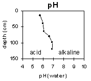
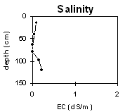
pH | Salinity Rating | |||
Surface (A1 horizon) | Moderately Acid | Very Low | - | None |
Subsoil (B21 horizon) | Slightly Acid | Very Low | Strongly Sodic | Complete |
Deeper subsoil (at 1 m) | Slightly Acid | Low | Strongly Sodic | Complete |
 |  |  |  |
Horizon | Horizon Depth cm | pH (water) | pH CaCl2 | EC dS/m | Exchangeable Cations | Field Capacity pF2.5 | Wilting Point pF4.2 | Coarse Sand (0.2-2.0mm) | Fine Sand (0.02-0.2mm) | Silt (0.002-0.02mm) | Clay (<0.002mm) | |||
Ca | Mg | K | Na | |||||||||||
meq/100g | ||||||||||||||
A1 | 0-30 | 5.7 | 4.7 | 0.09 | 2.9 | 1.9 | 0.2 | 0.1 | 23 | 10 | 34 | 29 | 19 | 15 |
A21 | 30-50 | 6 | 4.9 | 0.05 | 1.5 | 1.5 | 0.2 | 0.1 | 16.8 | 6.6 | ||||
A22 | 50-75 | 6.1 | 5 | 0 | 1.4 | 1.6 | 0.1 | 0.1 | 18.7 | 8.9 | 28 | 36 | 18 | 18 |
A23 | 75-85 | 6.6 | 5.3 | 0 | 0.7 | 1.1 | 0.1 | 0.2 | 10.9 | 5.8 | ||||
B21 | 85-110 | 6.9 | 5.8 | 0.16 | 2.9 | 11 | 0.3 | 3.2 | 39.8 | 26.6 | 13 | 16 | 20 | 46 |
B22 | 110+ | 6.9 | 5.9 | 0.22 | 2.7 | 11 | 0.3 | 3.7 | ||||||
Management Considerations:
Whole Profile
- Plant available water capacity (PAWC) is estimated to be relatively low (estimated at 65 mm). This is based on available laboratory data and assumes an effective rooting depth of 100 cm. Effective rooting depth will be restricted by the strongly sodic and dispersive subsoil. The low PAWC will limit pasture growth into dry a spring and summer.
- The surface (A) horizons have a much higher level of coarse sand than for the other sites examined. This will contribute to increased infiltration of water and reduced plant available water holding capacity.
- Organic carbon and total nitrogen levels are reasonable for the A1 horizons. Organic matter is important for maintaining surface soil aggregation. The relatively deep A1 horizon is important for plant growth as the deeper A2 horizons have a very low inherent fertility (based on the sum of the exchangeable cations).
- The dense and coarsely structured subsoil is strongly sodic and disperses completely (and has a low calcium:magnesium ratio of 0.3). This is likely to significantly restrict water and root movement through the subsoil. The conspicuously bleached A2 horizon above the sodic subsoil indicates that periodic waterlogging occurs. On sloping country there is likely to be significant lateral flow of water downslope, above the more impermeable clay subsoil.
- Was native pasture until ripped up 12 years ago. Fescue, phalaris and cocksfoot now grown. (Cocksfoot performs better than phalaris).
- More likely to get bogged here than on site LP65
© State of Victoria (Agriculture Victoria) 1996 - 2025.

This work, Victorian Resources Online, is licensed under a Creative Commons Attribution 4.0 licence. You are free to re-use the work under that licence, on the condition that you credit the State of Victoria (Agriculture Victoria) as author, indicate if changes were made and comply with the other licence terms.
The licence does not apply to ‘branding’ or some ‘images or photographs’ that may be owned by third parties. We ask you to seek prior approval to use images using the VRO feedback form. Access to higher quality images can also be provided on request.
This page was last updated on 23/03/2020.