
LP63
Location: Lexton
Australian Soil Classification: Ferric, Mottled-Subnatric, Brown SODOSOL
General Landscape Description: Midslope position on an undulating rise on Quaternary basaltic parent material. Ordovician sedimentary hills are located 200 m away.
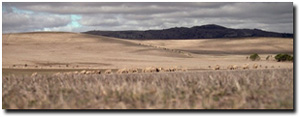 LP63 Landscape |
Soil Profile Morphology:
| Surface Soil | 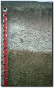 LP63 Profile | ||
| A11 | 0-15 cm | Dark brown (10YR3/3); light very fine sandy loam; weakly structured; firm consistence moist; pH 5.3; clear change to:
| |
| A12 | 15-20 cm | Brown (10YR5/3); light very fine sandy loam; massive; firm consistence moist; pH 4.8; abrupt change to:
| |
| A2 | 20-50 cm | Pale brown (10YR6/3) conspicuously bleached (10YR8/1d); fine sandy loam; massive; weak consistence moist; contains very many ferro-manganiferous nodules (1.5 cm size); pH 5.5; sharp change to:
| |
| Subsoil
| |||
| B21 | 50-80 cm | Yellowish brown (10YR5/4) with light yellowish brown (10YR5/6) and red (5YR5/8) mottles; medium-heavy clay; moderate medium prismatic, parting to moderate coarse blocky structure; very firm consistence moist; pH 6.2; gradual change to:
| |
| B22 | 80-105 cm | Pale brown (10YR6/3) with brownish yellow (10YR6/8) and red (2.5YR5/8) mottles; heavy clay; very firm consistence moist; pH 6.9; gradual change to:
| |
| B23 | 105 + cm | Grey (10YR5/1) with brownish yellow (10YR6/8) and red (2.5YR4/6) mottles; heavy clay; very firm consistence moist; pH 6.8. | |
Key Profile Features:
- Strong texture contrast between surface (A) horizons (clay content 8.5%) and subsoil (B21) horizon (clay content 69%).
- Conspicuously bleached subsurface (A2) horizon with many ferro-manganiferous nodules.
pH | Salinity Rating | |||
Surface (A1 horizon) | Strongly Acid | Low | - | None1 |
Subsoil (B21 horizon) | Slightly Acid | Very Low | Marginally Sodic | Moderate |
Deeper subsoil (at 1 m) | Slightly Acid | Very Low | Sodic | Strong |
 |  |  |  |
Horizon | Horizon Depth cm | pH (water) | pH CaCl2 | EC dS/m | Exchangeable Cations | Exchangeable Aluminium mg/kg | Field Capacity pF2.5 | Wilting Point pF4.2 | Coarse Sand (0.2-2.0mm) | Fine Sand (0.02-0.2mm) | Silt (0.002-0.02mm) | Clay (<0.002mm) | |||
Ca | Mg | K | Na | ||||||||||||
meq/100g | |||||||||||||||
A11 | 0-15 | 5.3 | 4.6 | 0.11 | 2 | 0.2 | 0.1 | 0.1 | 13 | 21.1 | 5.5 | 7 | 62 | 21 | 9 |
A12 | 15-20 | 4.8 | 4.3 | 0.11 | 0.8 | 0.2 | 0.1 | 0.1 | 30 | ||||||
A2 | 20-50 | 5.5 | 4.6 | 0 | 0.5 | 0.2 | 0.1 | <0.1 | 16.9 | 3.3 | |||||
B21 | 50-80 | 6.2 | 5.1 | 0.07 | 3 | 9.6 | 0.3 | 1.1 | 41.1 | 28.2 | 3 | 20 | 7 | 69 | |
B22 | 80-105 | 6.9 | 5.6 | 0.05 | 1.6 | 9.7 | 0.2 | 1.4 | |||||||
B23 | 105+ | 6.8 | 5.7 | 0.1 | 1.7 | 11 | 0.3 | 1.7 | |||||||
Management Considerations:
Whole Profile
- Plant available water capacity (PAWC) is relatively low (estimated at 85 mm) for this profile. This is based on the available laboratory data and assumes an effective rooting depth of 70 cm. Rooting depth will be limited by the sodic and dispersive subsoil. The low PAWC will limit pasture growth into a dry spring and summer.
- Aluminium and manganese toxicity can occur in strongly acid surface soils. The level of exchangeable aluminium measured in the laboratory suggests that highly sensitive species such as lucerne, medics and phalaris may be affected. Exchangeable aluminium values decrease with depth and are not likely to affect plant growth below 55 cm depth as the pH rises to above 5.5. Lime can be used to increase soil pH but it should be noted that a pH/aluminium test is best performed from samples taken across the paddock and bulked together. Other factors also need to be considered before lime is recommended (e.g. pasture species grown, method of application, local trial responses, soil surface structure and likely cost/benefit).
- The surface horizons have a very high fine sand (62%) and silt (21%) content. When cultivated in a dry condition such soils will become "powdery" and subsequent rain may form a surface crust. Cultivation of these soils when wet may result in surface sealing and exacerbation of the hardsetting condition on drying. Slight dispersion occurs after remoulding which also indicates that structural degradation may occur if over cultivated in a very moist to wet condition. Improving adequate organic matter levels is important to assist in reducing structural degradation (e.g. compaction) on such soils. Practices such as minimum tillage, stubble retention and pasture rotation should be encouraged if cropping occurs.
- The surface horizon has a very low inherent nutrient status (based on the sum of the exchangeable cations). Organic carbon levels are also low. Improving soil organic matter content will assist in enhancing soil fertility as well as water holding capacity in the surface (A1) horizon.
- Water and root movement will be restricted by the dense sodic and dispersive subsoil. The presence of a conspicuously bleached subsurface (A2) horizon above the sodic subsoil indicates that water movement is being restricted.
- As for Site 62, the calcium:magnesium ratio is low in the subsoil. This indicates that nutrient imbalances may exist (e.g. calcium and potassium deficiency) in the subsoil. The low calcium:magnesium ratio may also exacerbate the effect of sodicity on soil structure.
© State of Victoria (Agriculture Victoria) 1996 - 2025.

This work, Victorian Resources Online, is licensed under a Creative Commons Attribution 4.0 licence. You are free to re-use the work under that licence, on the condition that you credit the State of Victoria (Agriculture Victoria) as author, indicate if changes were made and comply with the other licence terms.
The licence does not apply to ‘branding’ or some ‘images or photographs’ that may be owned by third parties. We ask you to seek prior approval to use images using the VRO feedback form. Access to higher quality images can also be provided on request.
This page was last updated on 23/03/2020.