
Public Land
| Public land in the Glenelg-Hopkins Catchment Management (external link) region is dominated by National Parks, covering over 200 000 ha (200 km²). The Grampians National Park covers most of this area (ie. 167 100 ha). State Parks, Coastal Parks and Reference Areas combine to comprise almost 35 300 ha throughout the region. | 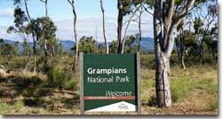 Grampians National Park |
This map shows the location of State and National Parks in the Glenelg-Hopkins region, and in nearby regions (as at January 2006). Data supplied by Parks Victoria. |
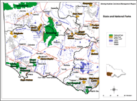
Parks and Reserves in the Glenelg Region
Park / Reserve Type | Area (ha) |
| National Parks | 202 204 |
| Coastal Parks | 11 007 |
| State Parks | 12 723 |
| Regional Parks | 2 463 |
| Reference Areas | 11 569 |
| Flora Reserves | 5 830 |
| Lake Reserves | 1 526 |
| Streamside Reserves | 1 669 |
| Bushland Reserves | 4 023 |
| Coastal reserves | 1 851 |
| Scenic reserves | 1 846 |
| Other reserves | 1 237 |
The Parks, Flora and Fauna (PFF) Division of DSE is responsible for overseeing the management of Victoria's land and resources for their environmental, conservation and recreational values. PFF is responsible for supporting the conservation of historic places on public land and overseeing the management and use of Crown land.
Crown Land Management (within the Land Victoria Division, DSE) (external link) has a number of roles and responsibilities with respect to the management of public land within the Glenelg-Hopkins Catchment Management Region, including:
- Acting on behalf of the Victorian Government as the agent for the Crown land outside of the parks and forests systems, the majority occupied by individuals and organisations/clubs other than the Department of Sustainability and Environment;
- Purchases, exchanges, sells, reserves and leases or licences land and property for DSE and other parts of Government;
- Providing policy and a regulatory framework for the reservation, management and use of Crown land;
- Facilitating major Government and private infrastructure projects through the commercial leasing, reservation and delegated management of Crown land;
- Maintaining the Crown land data base covering relevant Crown allotments;
- For the purposes of Native Title claims, researches and determines the tenure history of Crown land under claim and provides DSE policy input to the Government’s response to Native Title;
- Coordinating responses to land use planning proposals on behalf of DSE;
- Acting as a referral authority for proposed developments on private and Crown land;
- Providing new information technology developments and initiatives to support cadastral and natural resource decision-making and program delivery.
Actual management of land use activities has been undertaken by Parks Victoria (external link) since December 1996. Its main purpose with respect to Crown Land use is to conserve, protect and enhance environmental and cultural assets thoughout the region.
© State of Victoria (Agriculture Victoria) 1996 - 2025.

This work, Victorian Resources Online, is licensed under a Creative Commons Attribution 4.0 licence. You are free to re-use the work under that licence, on the condition that you credit the State of Victoria (Agriculture Victoria) as author, indicate if changes were made and comply with the other licence terms.
The licence does not apply to ‘branding’ or some ‘images or photographs’ that may be owned by third parties. We ask you to seek prior approval to use images using the VRO feedback form. Access to higher quality images can also be provided on request.
This page was last updated on 23/03/2020.