
Private Land
Approximately 81% of the Glenelg Region has been developed for agricultural use. Approximately 2% of the catchment comprises pine forest, 16% is native forest and less than 1% is used for urban and industrial development (Glenelg CaLPB, 1997). The main agricultural land uses are dominated by dryland pasture (over 2 million ha) and also include horticulture (10 462 ha), while less than 250 ha of irrigated pasture exists in the region.
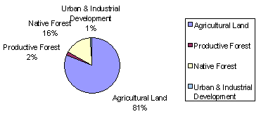 Source: Glenelg CaLPB (1997) |
Land use categories In Glenelg-Hopkins Catchment Management Region:
| Land Use Category | Area (ha) |
| Horticulture | 10 462 |
| Pasture - Irrigated | 249 |
| Pasture - Dryland | 2 081 025 |
| Remnant native vegetation | 64 540 |
| Forestry - private softwood | 11 925 |
| Forestry - public softwood | 4 020 |
| Other private land (non-farmland) | 42 781 |
| Unclassified | 5 373 |
| Available for hardwood utilisation | 166 411 |
| Not available for hardwood utilisation | 251 398 |
| Plantations | 39 061 |
| Unclassified (freehold land from Landmmt100) | 175 |
| Unknown | 227 |
| Total | 2 677 647 |
Sub-regional land use:
| The Hopkins River Basin, which covers an area of roughly 968 000 ha in the eastern half of the Glenelg-Hopkins Catchment Management Region, is entirely cleared for pasture and other agriculture, except for a small area of forest in the north. The main products of this basin are wool, prime lambs and beef. Cropping is practised in the north and market gardening in the south, where potatoes are a major produce. Dairying, common in the past, declined over the 1980s. | 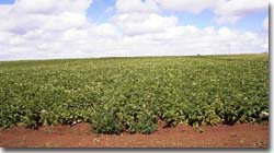 Koroit potato cropping |
The Portland Coast Basin, which covers just under 400 000 ha of land in the south of Glenelg-Hopkins, is a gently undulating to flat catchment which is mostly cleared for agriculture. The pastoral industry dominates in the Basin today with sheep and cattle being grazed for wool, meat and some dairying. Some areas carry cereal crops, vegetables and vinyards, while potatoes and orchids are particularly common in the Basin’s southeast and at Cashmore. Forested areas are generally of mixed hardwood species which are logged for construction purposes. While softwood production is only a relatively minor activity, it is growing with sawn timber and woodchip mills located in Portland and Heywood.
Land use in the Glenelg River Basin (1.26 million ha in the region’s west) is still largely wool production with prime lamb also significant. The beef industry is well established but dairy has been steadily declining in the recent past. Two thirds of the Basin has been cleared for pasture to graze sheep and cattle, and today, only two main forested areas remain. The northeast of the Basin is forested and includes the Grampians National Park, as well as State Forest where hardwood is logged. In the west, there is a mix of native hardwood forests (i.e. the Glenelg National Park) and intensive softwood plantations.
(DWR, 1989)
References:
Department of Water Resources, (1989) A Water Resource Handbook, Melbourne.
Glenelg Regional Catchment and Land Protection Board, (1997) Regional Catchment Strategy, Glenelg CaLPB, Hamilton.
© State of Victoria (Agriculture Victoria) 1996 - 2025.

This work, Victorian Resources Online, is licensed under a Creative Commons Attribution 4.0 licence. You are free to re-use the work under that licence, on the condition that you credit the State of Victoria (Agriculture Victoria) as author, indicate if changes were made and comply with the other licence terms.
The licence does not apply to ‘branding’ or some ‘images or photographs’ that may be owned by third parties. We ask you to seek prior approval to use images using the VRO feedback form. Access to higher quality images can also be provided on request.
This page was last updated on 23/03/2020.