GL83
Location: Winnap
Australian Soil Classification: Ferric-Sodic, Mesotrophic, Brown CHROMOSOL (confidence level 2)
General Landscape Description: Rolling low hills
Site Description: Mid to lower slope
Land Unit: Dundas Sedimentary
Geology: Tertiary sedimentary
General Land Unit Description: This land unit occurs on dissected slopes leading to valleys, predominantly in the southern portion of the study area. The dominant soil type is a Brown Chromosol, commonly with a ferric horizon above the occasionally sodic subsoil. The landform, along with the high percentage of ferruginous nodules above the clay are the major restrictions to land use. The sandy topsoil is susceptible to wind erosion.

Key profile features:
- Strong texture contrast between topsoil and subsoil
- Strongly acidic topsoil
- Bleached A2 horizon
- Mottled subsoil
- Sodic subsoil at depth
- Kaolinite at depth

Soil Profile Characteristics:
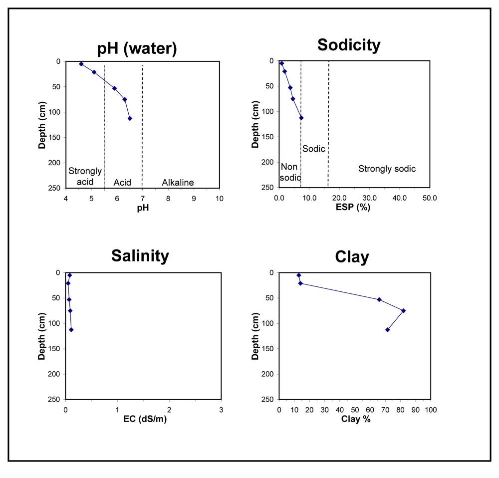
- | pH | Salinity | ||
Surface Soil (A1 horizon) | Very Strongly Acid | Low | Non-Sodic | None |
Subsoil (46-60 cm) | Moderately Acid | Very Low | Non-Sodic | None1 |
Deeper Subsoil (90 -135 cm) | Slightly Acid | Very Low | Sodic | None |
Chemical and Physical Analysis:
Horizon | Horizon Depth (cm) | pH (water) | pH (CaCl2) | EC dS/m | Organic Carbon % | Total Nitrogen % | Exchangeable Aluminium ppm | Exchangeable Acididty meq/100g | Exchangeable Cations | Coarse Sand (0.2-2.0 mm) % | Fine Sand (0.02-0.2 mm) % | Silt (0.002-0.02 mm) % | Clay (<0.002 mm) % | Field Capacity % w/w | Wilting Point % w/w | |||
Ca | Mg | K | Na | |||||||||||||||
meq/100g | ||||||||||||||||||
A1 | 0-10 | 4.6 | 4.0 | 0.08 | 4.2 | 0.28 | 67 | 13 | 1.0 | 0.63 | 0.27 | 0.13 | 16 | 49 | 14 | 13 | 24.7 | 8.2 |
A2 | 10-32 | 5.1 | 4.4 | <0.05 | 44 | 6.7 | 0.81 | 0.47 | 0.07 | 0.15 | 15 | 52 | 15 | 14 | 19.1 | 5.4 | ||
B21 | 46-60 | 5.9 | 4.8 | 0.07 | 23 | 11 | 2.3 | 5.3 | 0.18 | 0.72 | 6 | 20 | 5 | 66 | 35.7 | 23.7 | ||
B22 | 60-90 | 6.3 | 5.6 | 0.09 | <10 | 12 | 2.4 | 7.8 | 0.22 | 1.1 | 3 | 9 | 6 | 82 | 46.6 | 30.2 | ||
B23 | 90-135 | 6.5 | 6.0 | 0.11 | 9.7 | 2.0 | 8.0 | 0.18 | 1.6 | 5 | 10 | 12 | 72 | 43.7 | 27 | |||
Profile Described By: Natalie Baxter and Grant Boyle, 8th October 2000.


