GL77
Location: Greenwald
Australian Soil Classification: Ferric, Eutrophic, Brown, CHROMOSOL (confidence level 1)
General Landscape Description: Undulating rises
Site Description: Upper slope
Land Unit: Gorae Basalt
Geology: Quaternary basalt
General Land Unit Description: This land unit has a variety of soil types occurring over a short distance. Ferrosols and Black Chromosols are found is association with the more dominant Ferric Brown Chromosols. The Brown Chromosols have been used to represent this area as they are deemed to be the major soil type, and due to restrictions of scale the other soil types have not been mapped as individual units. It must be noted however, that the better drained soils (Red Ferrosols / Dermosols) have a higher capability of supporting a range of land uses (e.g. viticulture) due to their favourable physical and chemical properties.
Soil Profile Morphology
Surface Soil
| A11 | 0-10 cm | Dark brown (7.5YR3/3) loamy sand, apedal to weak structure, weak consistence when dry, many ferromanginferous nodules and a few medium subrounded basalt pebbles (2-10 mm), pH 6.3; transition to:
|
| A12 | 10-40 cm | Dark brown (7.5YR3/3) sandy loam, weak polyhedral structure (2-10 mm), ferromangiferous nodules are abundant, pH 6.1; transition to:
|
| Subsoil
| ||
| B2 | 40-70 cm | Strong brown (7.5YR4/6) sandy clay, many distinct red mottles, weak subangular blocky structure (5-10 mm), very firm consistence when dry, ferromangaiferous nodules and angular basalt fragments are abundant, pH 6.2.
|
Key profile features:
- Strong texture contrast between topsoil and subsoil
- Mottled subsoil
- Ferromangiferous nodules and coarse fragments are abundant throughout
Soil Profile Characteristics:
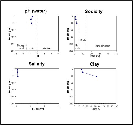
- | pH | Salinity | ||
Surface Soil (A11 horizon) | Slightly Acid | Low | Non-Sodic | None |
Subsoil (40-70 cm) | Slightly Acid | Low | Non-Sodic | None |

Chemical and Physical Analysis:
Horizon | Horizon Depth (cm) | pH (water) | pH (CaCl2) | EC dS/m | Organic Carbon % | Total Nitrogen % | Exchangeable Aluminium ppm | Exchangeable Acididty meq/100g | Exchangeable Cations | Coarse Sand (0.2-2.0 mm) % | Fine Sand (0.02-0.2 mm) % | Silt (0.002-0.02 mm) % | Clay (<0.002 mm) % | Field Capacity % w/w | Wilting Point % w/w | |||
Ca | Mg | K | Na | |||||||||||||||
meq/100g | ||||||||||||||||||
A11 | 0-15 | 6.3 | 4.9 | 0.09 | 10 | 0.45 | 15 | 21 | 14 | 4.4 | 0.96 | 0.54 | 25 | 29 | 12 | 17 | 33.4 | 20.2 |
A12 | 15-25 | 6.1 | 5.6 | 0.11 | <10 | 11 | 3.9 | 1.6 | 0.50 | 0.26 | 29 | 33 | 14 | 20 | 24.2 | 12.1 | ||
B2 | 25-45 | 6.2 | 5.8 | 0.12 | <10 | 11 | 2.2 | 4.0 | 0.27 | 0.50 | 13 | 21 | 13 | 53 | 38.2 | 24.4 | ||
Profile Described By: Natalie Baxter and Grant Boyle, 5th October 2000.


