
GL26
Location: Bahgallah
Australian Soil Classification: Hypercalcic, Subnatric, Grey SODOSOL (confidence level 1)
General Landscape Description: Plain
Site Description: Swale, 2% slope
Land Unit: Follet Dunes and Plains
Geology: Quaternary aeolian
General Land Unit Description: The majority of this land unit falls south of the Kanawinka fault. This land unit comprises areas with deep sand deposits. The residual landscape is thought to be influenced by the retreat of the Murray Sea which left stranded beach ridges oriented south west–north east. These were subsequently covered by superficial sand sheets in later depositional phases, which formed the landscape seen today.
The major landforms in this land unit are dunes and swales. Podosols and Kurosols or Chromosols are the major soil types found on the dunes and rises. Podosols are soils with a ‘coffee rock’ layer (refer to photograph). The Kurosols or Chromosols tend to have a deep sandy topsoil over the clay. The common soil types on the swales are black cracking clay (Vertosols) or Grey Sodosols. Some Ferric Kurosols or Chromosols can also occur on the swales or lower slopes of the dunes.
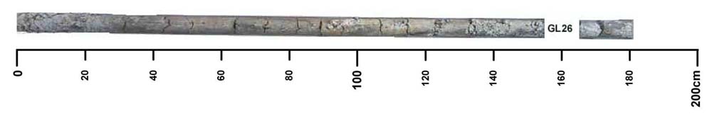
Soil Profile Morphology
| A11 | 0-15 cm | Loamy sand; changes to:
|
| A12 | 15-35 cm | Dark grey (10YR4/1); loamy sand; apedal structure; pH 6.8; changes to:
|
| A31 | 35-55 cm | Black (10YR2/1); clay sand; massive structure; pH 7.4; changes to:
|
| A33 | 55-90 cm | Dark greyish brown (10YR4/2); loamy sand; massive structure; contains very few fine soft calcareous segregations; pH 8.1; changes to:
|
| Subsoil | ||
| B21 | 90-120 cm | Grey (10YR5/1), with many faint yellow mottles; sandy clay; massive to weak structure; contains common medium soft calcareous segregations and nodules; pH 8.8; changes to:
|
| B22 | 120-190 cm | Dark grey (10YR4/1); sandy clay; massive to weak structure; contains many medium soft calcareous segregations and nodules; pH 9.0; changes to:
|
| C | 190-220+ cm | Massive structure. |
Key profile features:
- Strong texture contrast between topsoil and subsoil
- Sandy topsoil
- Calcareous nodules throughout
- Strongly alkaline subsoil
- Sodic surface horizon
- Sodic subsoil
- Mottled subsoil
- Deeper topsoil dispersive when worked when wet
- Subsoil dispersive when worked when wet
Soil Profile Characteristics:
- | pH | Salinity | ||
Surface Soil (A12 horizon) | Slightly Acid | Medium | Strongly Sodic | None |
Subsoil (90-120 cm) | Strongly Alkaline | Medium | Sodic | None1 |
Deeper Subsoil (120 -190 cm) | Strongly Alkaline | Medium | Sodic | None |
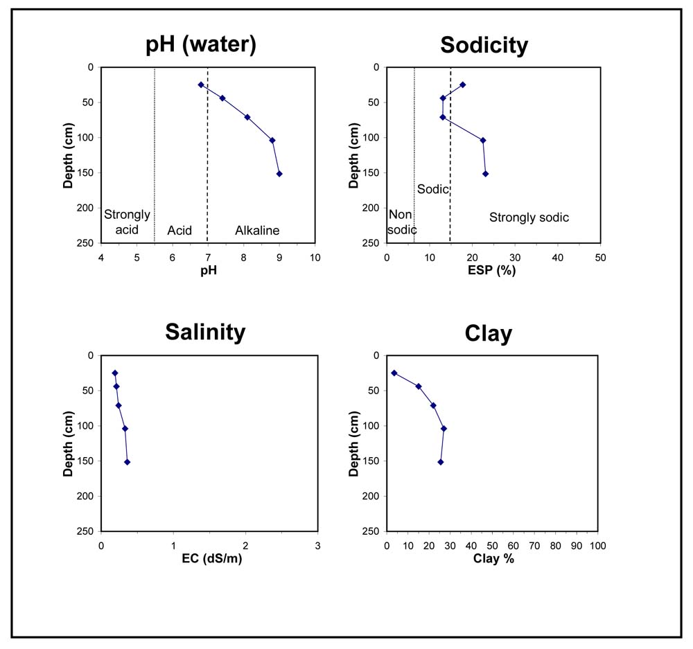
Chemical and Physical Analysis:
Horizon | Horizon Depth (cm) | pH (water) | pH (CaCl2) | EC dS/m | Exchangeable Cations | Coarse Sand (0.2-2.0 mm) % | Fine Sand (0.02-0.2 mm) % | Silt (0.002-0.02 mm) % | Clay (<0.002 mm) % | Field Capacity % w/w | Wilting Point % w/w | |||
Ca | Mg | K | Na | |||||||||||
meq/100g | ||||||||||||||
A11 | 0-15 | |||||||||||||
A12 | 15-35 | 6.8 | 6.1 | 0.19 | 1.8 | 0.57 | 0.11 | 0.55 | 33 | 59 | 3 | 4 | 5.0 | 1.9 |
A31 | 35-55 | 7.4 | 6.6 | 0.21 | 5.7 | 2.6 | 0.23 | 1.3 | 29 | 52 | 3 | 15 | 15.1 | 7.0 |
A33 | 55-90 | 8.1 | 7.2 | 0.24 | 7.4 | 3.3 | 0.27 | 1.7 | 27 | 47 | 3 | 22 | 22.0 | 9.8 |
B21 | 90-120 | 8.8 | 8.1 | 0.33 | 9.8 | 3.8 | 0.4 | 1.8 | 25 | 40 | 4 | 27 | 27.9 | 12.9 |
B22 | 120-190 | 9.0 | 8.3 | 0.36 | 8.4 | 3 | 0.3 | 1.5 | 22 | 33 | 3 | 26 | 27.1 | 12.0 |
Profile Described By: Natalie Baxter and Grant Boyle, 2nd October 2000.
© State of Victoria (Agriculture Victoria) 1996 - 2025.

This work, Victorian Resources Online, is licensed under a Creative Commons Attribution 4.0 licence. You are free to re-use the work under that licence, on the condition that you credit the State of Victoria (Agriculture Victoria) as author, indicate if changes were made and comply with the other licence terms.
The licence does not apply to ‘branding’ or some ‘images or photographs’ that may be owned by third parties. We ask you to seek prior approval to use images using the VRO feedback form. Access to higher quality images can also be provided on request.
This page was last updated on 23/03/2020.