GL170b
Australian Soil Classification: Vertic, Mottled- Mesotrophic, Brown SODOSOL (confidence level 1)
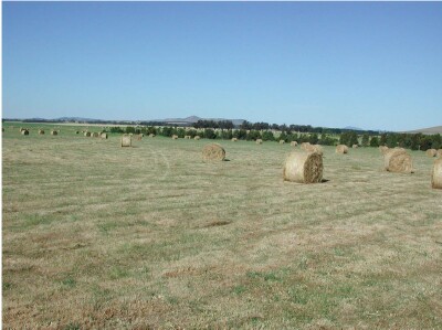
General Landscape Description: Lava Plain
Site Description: South facing 3% slope
Land Unit: Willaura Basalt
Geology: Quaternary basalt
General Land Unit Description: This land unit occurs on the level to gently undulating plains between Moyston and Willarua. The soils are commonly sodic and exhibit gilgai micro-relief although due to land management gilgais are not always apparent on the surface. The soil description below represents the lighter textured topsoil which is possibly the swale. The hummock generally is black cracking clay with evidence of patchy calcium carbonate. Soil depth is variable due to basalt floaters. On the broad flat crest and level areas, particularly in the southern portion of the land unit, the soils can have a conspicuously bleached A2 horizon. Numerous grey clay swamps and depressions are scattered throughout this map unit. Occasionally Red or Brown Chromosols or Sodosols may be found on banks surrounding these swamps.

Soil Profile Morphology:
| Surface Soil | |||
| A1 | 0-15 cm | Dark yellowish brown (10YR4/3); fine sandy clay loam; weak medium subangular blocky structure; firm consistence, dry, pH 5.4; changes to: | |
| A2 | 15-30 cm | Brown (10YR5/3), with many prominent coarse yellowish brown (10YR5/8) mottles; heavy clay; strong coarse prismatic parting to strong coarse angular blocky structure; very strong consistence, dry; contains very few prominent medium soft calcareous segregations; common distinct organic cutans are evident; pH 7.8; changes to: | |
Subsoil | |||
| B21 | 30-55 cm | Very dark grey (2.5Y3/1); heavy clay; many distinct slickensides present; pH 8.0; changes to: | |
| B22 | 55-90+ cm | Black (2.5Y2.5/1); heavy clay; contains very few distinct medium soft calcareous segregations ; many distinct slickensides present; pH 9.0.1 |
Key Profile Features:
- Acidic topsoil
- Strong texture contrast between topsoil and subsoil
- Mottled subsoil
- Sodic subsoil
- Subsoil cracks
- Topsoil dispersive when worked when wet
- Subsoil dispersive when dry
Soil Profile Characteristics:
- | pH | Salinity | ||
Surface Soil (A1 horizon) | Strongly Acid | Very Low | Non-Sodic | None1 |
Subsoil (30-55 cm) | Moderately Alkaline | Low | Strongly Sodic | Complete1 |
Deeper Subsoil (55-90 cm) | Strongly Alkaline | Low | Strongly Sodic | Moderate2 |
Chemical and Physical Analysis:
Horizon | Horizon Depth (cm) | pH (water) | pH (CaCl2) | EC dS/m | Organic Carbon % | Total Nitrogen % | Exchangeable Aluminium ppm | Exchangeable Acididty meq/100g | Exchangeable Cations | Coarse Sand (0.2-2.0 mm) % | Fine Sand (0.02-0.2 mm) % | Silt (0.002-0.02 mm) % | Clay (<0.002 mm) % | Field Capacity % w/w | Wilting Point % w/w | |||
Ca | Mg | K | Na | |||||||||||||||
meq/100g | ||||||||||||||||||
A1 | 0-15 | 5.4 | 4.5 | 0.07 | 1.5 | 0.13 | 44 | 10 | 3.7 | 2.8 | 0.33 | 0.52 | 9 | 39 | 21 | 27 | 28 | 17.7 |
A2 | 15-30 | 5.9 | 4.8 | 0.06 | <10 | 5.7 | 2.2 | 1.7 | 0.19 | 0.48 | 9 | 45 | 27 | 18 | 22.5 | 6.8 | ||
B21 | 30-55 | 8.0 | 6.9 | 0.21 | 1.1 | 0.08 | 12 | 12 | 0.83 | 0.34 | 3 | 25 | 14 | 55 | 44.3 | 22.4 | ||
B21 | 55-90 | 9.0 | 8.3 | 0.54 | 10 | 12 | 0.5 | 5.2 | 43.5 | 22.6 | ||||||||
Profile Described By: Natalie Baxter, 29 November 2000.


