
GL164
Location: Balmoral
Australian Soil Classification: Melanic-Mottled (& Ferric), Mesotrophic, Brown CHROMOSOL
Northocte Factual Key: Db2.41
General Land Unit Description: This site is situated on the level surface of the Dundas Tablelands.
Site Description: Level plain. Moderately well drained.
Geology: Tertiary marine sandstone.
Native Vegetation: Red gums are the dominant vegetation.
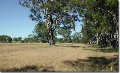 GL164 Landscape |
Soil Profile Morphology:
Surface Soil
| A1 | 0-25 cm | Very dark grey (7.5YR3/1) sandy loam; weak medium blocky structure; weak consistence dry; very few medium angular ferruginised nodules (6-20 mm); pH 6.5; clear and wavy change to: | 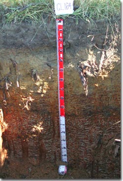 GL164 Profile |
| A2 | 25-40 cm | Dark yellowish brown (10YR4/4) fine sandy clay loam; weak to massive medium blocky structure, firm consistence moist; many medium to coarse ferruginous and manganiferous nodules; pH 4.7; clear and wavy change to: | |
| Subsoil | |||
| B2 | 40-60 cm | Dark yellowish brown (10YR4/6) light medium clay (sandy); weak fine blocky structure; firm consistence moist; many coarse ferruginous and manganiferous nodules; pH 5.5; clear and wavy change to: | |
| BC | 60-85 cm | Mainly buckshot; ferruginous and manganiferous nodules are abundant; moderately cemented discontinuous, may be cemented (petroferric). ; ferricrete pan; abrupt and wavy change to: | |
| C | 85-150 cm | ||
NOTE: The soil is developed over a highly weathered mottled zone. The mottled zone, sometimes referred to as ‘tiger mottling’, is thought to be the result of fluctuating watertables which occurred mainly in the Tertiary period.
Key Profile Features:
- Strong texture contrast between surface (A) horizons and subsoil (B) horizons.
- Ferric pan at base of subsoil.
Soil Profile Characteristics:
pH | Salinity Rating | |||
Surface (A1 horizon) | Slightly Acid | Low | Non-Sodic | None |
Subsoil (40-60 cm) | Strongly Acid | Low | Non-Sodic | None |
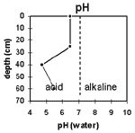 | 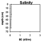 | 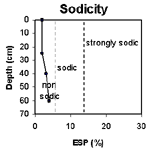 | 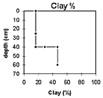 |
| The surface horizon is slightly acid. the subsoil is strongly acid. | The salinity rating for both the surface and subsoil is low. | The surface and the subsoil are non-sodic. | There is a sharp increase in clay content at 40 cm. |
Horizon | Horizon Depth (cm) | pH (water) | pH (CaCl2) | EC dS/m | Organic Carbon % | Total Nitrogen % | Exchangeable Aluminium ppm | Exchangeable Acididty meq/100g | Exchangeable Cations | Coarse Sand (0.2-2.0 mm) % | Fine Sand (0.02-0.2 mm) % | Silt (0.002-0.02 mm) % | Clay (<0.002 mm) % | Field Capacity % w/w | Wilting Point % w/w | |||
Ca | Mg | K | Na | |||||||||||||||
meq/100g | ||||||||||||||||||
A1 | 0-25 | 6.5 | 6.0 | 0.11 | 2.4 | 0.21 | 7.8 | 8.1 | 2.2 | 0.42 | 0.38 | 14 | 54 | 9 | 17 | 20 | 9 | |
A2 | 25-40 | 4.7 | 4.0 | 0.08 | 220 | 11 | 0.54 | 1.7 | 0.12 | 0.4 | 13 | 47 | 8 | 30 | 20 | 9 | ||
B21 | 40-60 | 5.5 | 4.6 | 0.08 | 53 | 9.8 | 1.4 | 4.0 | 0.16 | 0.68 | 10 | 35 | 8 | 47 | 27 | 15 | ||
Profile Described By: Natalie Baxter, Nathan Robinson, Grant Boyle and Mark Imhof (October 2001).
© State of Victoria (Agriculture Victoria) 1996 - 2025.

This work, Victorian Resources Online, is licensed under a Creative Commons Attribution 4.0 licence. You are free to re-use the work under that licence, on the condition that you credit the State of Victoria (Agriculture Victoria) as author, indicate if changes were made and comply with the other licence terms.
The licence does not apply to ‘branding’ or some ‘images or photographs’ that may be owned by third parties. We ask you to seek prior approval to use images using the VRO feedback form. Access to higher quality images can also be provided on request.
This page was last updated on 23/03/2020.