
GL160
Australian Soil Classification: Vertic, Mottled-Subnatric, Brown SODOSOL (confidence level 1)
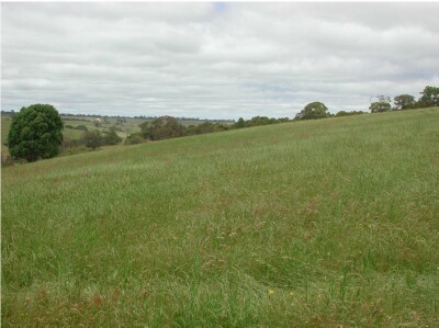
General Landscape Description: Low hills.
Site Description: Upper slope. Slope 12%.
Land Unit: Glenelg River Granite.
Geology: Cambrian granite.
General Land Unit Description: In the steeper dissected valleys of the tablelands, where the duricrust has been eroded, weathered parent material becomes exposed. The soils at this site appear to have been developed over weathered granitic rock, one of the many types of parent material found in the Dundas tablelands. The site is located on an upper slope off the tableland, leading to a water course. This site illustrates the range of soil types and parent material that have been exposed due to weathering of the tablelands and highlights the difficulty of mapping all the geologies and soil types at this scale.
Soil Profile Morphology:
Horizon | Depth (cm) | |||
A1 | 0-5 | Dark greyish brown (10YR4/2); loamy sand; weak fine subangular blocky structure; firm to weak consistence, dry; pH 5.2; clear change to: | 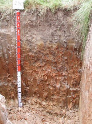 | |
A21 | 5–15 | Brown (10YR5/3),conspicuously bleached (10YR6/2d); loamy sand; massive structure; very firm consistence, dry; pH 5.1; gradual change to: | ||
A22 | 15–50 | Brown (10YR5/3), conspicuously bleached (10YR7/1d), with a few faint medium yellow mottles; light loamy sand ; massive structure; firm consistence, dry; pH 5.5; clear change to: | ||
A23 | 50-60 | Very pale brown (10YR7/3), clayey sand to sandy clay loam, conspicuously bleached (10YR82) when dry, many distinct coarse yellowish brown (10YR5/6) mottles, massive structure, firm consistence when dry, few medium subangular quartz pebbles (6-20 mm), pH 5.9. Clear to abrupt transition to: | ||
B2 | 60-100 | Brown (10YR4/3), with many prominent medium dark yellowish brown (10YR4/6) strong brown (7.5YR5/6) and light yellowish brown (2.5Y6/3) mottles; heavy clay; weak very coarse columnar structure parting to strong lenticular structure; firm consistence, dry; a few distinct clay skins evident; pH 6.5; gradual change to: | ||
B3 | 100-160 | Light olive brown (2.5YR5/3), with many prominent coarse red (2.5YR4/6) and yellowish red (5YR5/6) mottles; heavy clay; moderate lenticular structure, pH 6.1; abrupt change to: | ||
C | 160+ | Weathered granite | ||
Soil Profile Characteristics:
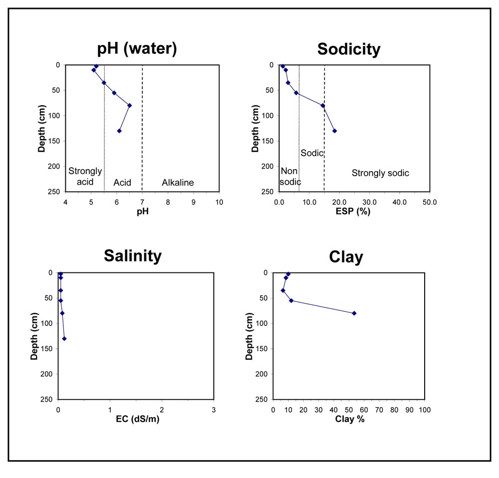
- | pH | Salinity | ||
Surface Soil (A1 horizon) | Strongly Acid | Very Low | Non Sodic | None |
Subsoil (60-100 cm) | Slightly Acid | Very Low | Sodic | Slight1 |
Deeper Subsoil (100-160 cm) | Slightly Acid | Very Low | Strongly Sodic | Complete |
Chemical and Physical Analysis:
Horizon | Horizon Depth (cm) | pH (water) | pH (CaCl2) | EC dS/m | Organic Carbon % | Total Nitrogen % | Exchangeable Aluminium ppm | Exchangeable Acididty meq/100g | Exchangeable Cations | Coarse Sand (0.2-2.0 mm) % | Fine Sand (0.02-0.2 mm) % | Silt (0.002-0.02 mm) % | Clay (<0.002 mm) % | Field Capacity % w/w | Wilting Point % w/w | |||
Ca | Mg | K | Na | |||||||||||||||
meq/100g | ||||||||||||||||||
A1 | 0-5 | 5.2 | 4.5 | <0.05 | 2.1 | 0.13 | 17 | 6.6 | 1.6 | 0.7 | 0.09 | 0.11 | 49 | 28 | 8 | 10 | 16 | 5.4 |
A21 | 5–15 | 5.1 | 4.4 | <0.05 | 21 | 4.6 | 0.7 | 0.35 | 0.07 | 0.13 | 51 | 30 | 8 | 9 | 12.8 | 3.6 | ||
A22 | 15–50 | 5.5 | 4.8 | <0.05 | <10 | 1.9 | 0.37 | 0.22 | <0.05 | 0.08 | 56 | 28 | 6 | 7 | 9.4 | 1.9 | ||
A23 | 50-60 | 5.9 | 5.1 | <0.05 | <10 | 1.1 | 0.43 | 0.54 | <0.05 | 0.13 | 52 | 24 | 9 | 12 | 10.7 | 4.2 | ||
B2 | 60-100 | 6.5 | 5.3 | 0.08 | <10 | 1.1 | 4.6 | 0.16 | 1 | 28 | 14 | 5 | 54 | 28.8 | 17.5 | |||
B3 | 100-160 | 6.1 | 4.9 | 0.12 | 0.85 | 5.1 | 0.16 | 1.4 | ||||||||||
Key Profile Features:
- Acidic topsoil
- Strong textural contrast between topsoil and subsoil
- Mottled subsoil
- Sodic subsoil
- Subsoil dispersive when dry
© State of Victoria (Agriculture Victoria) 1996 - 2025.

This work, Victorian Resources Online, is licensed under a Creative Commons Attribution 4.0 licence. You are free to re-use the work under that licence, on the condition that you credit the State of Victoria (Agriculture Victoria) as author, indicate if changes were made and comply with the other licence terms.
The licence does not apply to ‘branding’ or some ‘images or photographs’ that may be owned by third parties. We ask you to seek prior approval to use images using the VRO feedback form. Access to higher quality images can also be provided on request.
This page was last updated on 23/03/2020.