
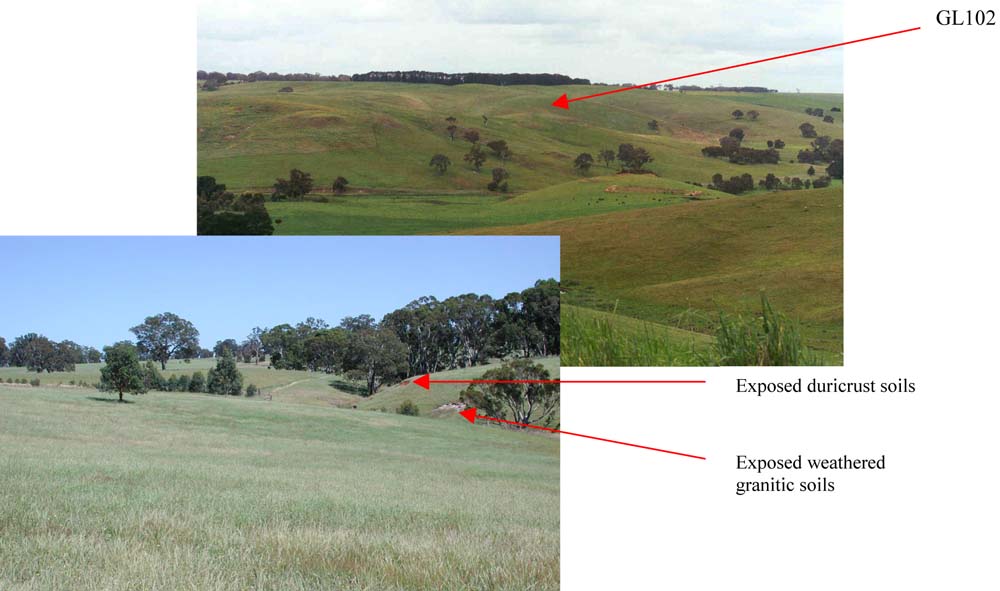
GL102
Location: Casterton
Australian Soil Classification: Melanic, Subnatric, Brown SODOSOL (confidence level 1)
General Landscape Description: Rolling low hills
Site Description: Crest
Land Unit: Merino Tablelands
Geology: Cainozoic duricrust
General Land Unit Description: In the steeper dissected valleys, where the duricrust has been eroded, weathered parent material becomes exposed. The major soil type occurring on the steeper slopes leading off the flat surface of the Dundas Tablelands is a Brown Chromosol, typically with a ferric horizon above the clay subsoil, similar to this site. The soil is developed over a highly weathered mottled zone. This red and white mottling, sometimes referred to as ‘tiger mottles’ is thought to be the result of fluctuating watertables which occurred mainly in the Tertiary period.
Soil Profile Morphology
| A1 | 0-15 cm | Very dark greyish brown (10YR3/2); loamy sand; weak structure; firm consistence, dry; common small round ferricrete pebbles are present; pH 5.7; changes to:
|
| A3 | 15-30 cm | Dark brown (10YR3/3); sandy clay loam; apedal structure; firm consistence, dry; contains abundant medium rounded ferruginised nodules; pH 6.0; changes to:
|
| Subsoil | ||
| B21 | 30-50 cm | Yellowish brown (10YR5/6); sandy light clay; weak to apedal structure; pH 6.2. |
Key profile features:
- Ferruginous nodules are abundant above the clay
- Strong textural contrast between topsoil and subsoil
Soil Profile Characteristics:
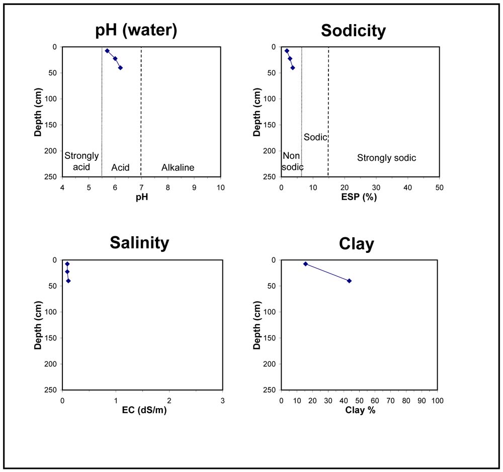
- | pH | Salinity | ||
Surface Soil (A1 horizon) | Moderately Acid | Low | Non-Sodic | None |
Subsoil (30-50 cm) | Slightly Acid | Very Low | Non-Sodic | None |
Chemical and Physical Analysis:
Horizon | Horizon Depth (cm) | pH (water) | pH (CaCl2) | EC dS/m | Organic Carbon % | Total Nitrogen % | Exchangeable Aluminium ppm | Exchangeable Acididty meq/100g | Exchangeable Cations | Coarse Sand (0.2-2.0 mm) % | Fine Sand (0.02-0.2 mm) % | Silt (0.002-0.02 mm) % | Clay (<0.002 mm) % | Field Capacity % w/w | Wilting Point % w/w | |||
Ca | Mg | K | Na | |||||||||||||||
meq/100g | ||||||||||||||||||
A1 | 0-15 | 5.7 | 5.0 | 0.09 | 1.4 | 0.1 | 13 | 7.7 | 2.1 | 1.4 | 0.47 | 0.21 | 20 | 51 | 11 | 16 | 24.8 | 6.7 |
A3 | 15-30 | 6.0 | 5.3 | 0.09 | 10 | 7.1 | 1.8 | 1.6 | 0.49 | 0.31 | 23.4 | 8.0 | ||||||
B21 | 30-50 | 6.2 | 5.6 | 0.11 | <10 | 8.1 | 1.8 | 4 | 0.36 | 0.53 | 21 | 29 | 6 | 44 | 30.4 | 15.7 | ||
Profile Described By: Natalie Baxter and Grant Boyle, 9th October 2000.
© State of Victoria (Agriculture Victoria) 1996 - 2025.

This work, Victorian Resources Online, is licensed under a Creative Commons Attribution 4.0 licence. You are free to re-use the work under that licence, on the condition that you credit the State of Victoria (Agriculture Victoria) as author, indicate if changes were made and comply with the other licence terms.
The licence does not apply to ‘branding’ or some ‘images or photographs’ that may be owned by third parties. We ask you to seek prior approval to use images using the VRO feedback form. Access to higher quality images can also be provided on request.
This page was last updated on 23/03/2020.