
GHF14b
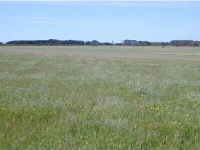
Location: Macarthur
Australian Soil Classification: Ferric (and Magnesic), Mottled-Subnatric, Yellow SODOSOL (very thick sandy surface soil)
General Landscape Description: Undulating rises
Site Description: Flat
Land Unit: Byaduk basalts
Geology: Quaternary basalt
General Land Unit Description: This land unit is a complex unit of steep slopes leading to drainage lines and gently undulating plains leading to the slopes, south east of Branxholme. The soils on the slopes leading to the drainage lines tend to be shallower than those on the plains. The soils on the plains commonly have a sandy topsoil with a bleached A2 horizon over a clay subsoil. A co-dominant soil type is a soil type lacking the sandy topsoil and tends to have a gradual increase in clay (Dermosol) similar to this site. These soils are intermixed with Sodosols.
Soil Profile Morphology
Surface
| A1 | 0-20 cm | Very dark grey (10YR3/1) loamy sand; single grain structure; loose consistence when moderately moist; many medium roots; clear and smooth transition to:
| 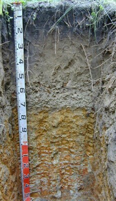 |
| A21 | 20-55 cm | Dark yellowish brown (10YR4/4) sand; single grain structure; loose consistence when moderately moist; few fine roots; clear and smooth transition to:
| |
| Subsoil
| |||
| B21 | 75-110 cm | Light yellowish brown (10YR6/4) with many very coarse distinct strong brown (7.5YR5/6) and yellowish red (5YR5/6) mottles, light medium clay; moderate polyhedral structure (20-50 mm) parting to moderate polyhedral structure (5-10 mm); weak consistence when moderately moist; very few coarse ferruginous nodules; common very fine macropores; areal porosity 0.3%; few very fine roots; diffuse and smooth transition to:
| |
| B22 | 110-150 cm | Brown (10YR7/1) with many very coarse prominent dark yellowish brown (10YR4/8) and yellowish red (5YR5/8) mottles in horizontal bands, light medium clay; weak polyhedral structure (20-50 mm); firm consistence when moderately moist; few very fine macropores; areal porosity 0.05%; few very fine roots.
| |
| 150-210 cm | Similar to layer above.
| ||
| 210-300 cm | Sandy clay, few remnant and live roots observed.
| ||
| 300-370 cm | Grey clays, iron mottling, extremely compacted, no roots observed. Difficult for backhoe to dig through, and is an impeding layer to root growth. |
Soil Profile Characteristics:
- | pH | Salinity | ||
Surface Soil (A1 horizon) | Very Strongly Acid | Very Low | Non-Sodic | None |
Subsoil (B21 Horizon) | Slightly Acid | Very Low | Sodic | None |
Deeper Subsoil (110-150 cm) | Moderately Acid | Low | Sodic | None |
Chemical and Physical Analysis:
Horizon | Horizon Depth (cm) | pH (water) | pH (CaCl2) | EC dS/m | Organic Carbon % | Total Nitrogen % | Exchangeable Aluminium ppm | Exchangeable Acididty meq/100g | Exchangeable Cations | Coarse Sand (0.2-2.0 mm) % | Fine Sand (0.02-0.2 mm) % | Silt (0.002-0.02 mm) % | Clay (<0.002 mm) % | Field Capacity % w/w | Wilting Point % w/w | |||
Ca | Mg | K | Na | |||||||||||||||
meq/100g | ||||||||||||||||||
A1 | 0-20 | 4.5 | 3.9 | <0.05 | 2.7 | 0.16 | 28 | 1.3 | 0.41 | 0.07 | <0.05 | 62 | 24 | 5 | 5 | 9 | 6 | |
A21 | 20-55 | 5 | 4.5 | <0.05 | 41 | 0.42 | 0.15 | <0.05 | <0.05 | 61 | 28 | 6 | 5 | 6 | 2 | |||
A22 | 55-75 | 6.1 | 5.5 | <0.05 | <10 | 0.86 | 0.53 | <0.05 | 0.12 | |||||||||
B21 | 75-110 | 6.4 | 6 | 0.11 | <10 | 7.1 | 0.79 | 5.4 | 0.09 | 0.99 | 28 | 13 | 5 | 55 | 27 | 23 | ||
B22 | 110-150 | 5.7 | 5.4 | 0.12 | 7.3 | 0.32 | 5.3 | 0.08 | 1.2 | |||||||||
Profile Described By: Ian Sergeant, Paul Feikema and Martin Clark (October 2000)
© State of Victoria (Agriculture Victoria) 1996 - 2025.

This work, Victorian Resources Online, is licensed under a Creative Commons Attribution 4.0 licence. You are free to re-use the work under that licence, on the condition that you credit the State of Victoria (Agriculture Victoria) as author, indicate if changes were made and comply with the other licence terms.
The licence does not apply to ‘branding’ or some ‘images or photographs’ that may be owned by third parties. We ask you to seek prior approval to use images using the VRO feedback form. Access to higher quality images can also be provided on request.
This page was last updated on 23/03/2020.