GHF11d
Location: Macarthur
Australian Soil Classification: Melacic, Humic/Humosesquic, Semiaquic PODOSOL
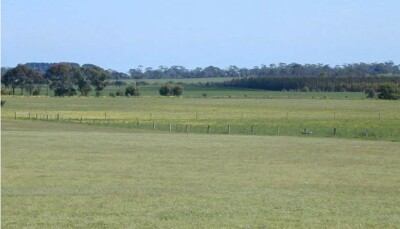
General Landscape Description: Level plain
Site Description: Northerly facing gentle slope
Land Unit: Warrakbook Basalts
Geology: Quaternary basalt
General Land Unit Description: This land unit consists of gently undulating basalt plains in the Macarthur area. In some drainage lines, the basalt has been dissected sufficiently to expose the underlying sediments. The soils on the basalt plains are commonly Brown Kurosols or Chromosols, intermixed with Sodosols, particularly on the lower slopes and drainage depressions. This site has two year old Eucalyptus globulus in a plantation on ex-agricultural land.

Soil Profile Morphology
Surface
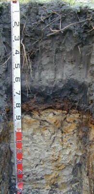
| A1 | 0-35 cm | Black (10YR2/1) loamy sand, single grain structure, loose consistence when moist, many coarse roots. Clear and smooth transition to:
|  |
| A12 | 35-60 cm | Grey (10YR6/1) sand, single grain structure, loose consistence when moist, common medium roots. Abrupt and smooth transition to: | |
| Subsoil
| |||
| Bh | 60-75 cm | Black (10YR2/1) loamy sand, single grain structure, very weak consistence when moist, common medium roots. Sharp and wavy transition to:
| |
| Bs | 75-80 cm | Black (5YR2.5/1) with many medium faint dark reddish brown (10YR3/4) motlles, loamy sand, unable to assess structure, strong consistence when wet, moderately cemented continuous massive organic pan, no roots observed. Sharp and wavy transition to:
| |
| A3 | 85-88 cm | White (10YR8/2) with common medium faint brownish yellow (10YR6/6), loamy sand, single grain structure, very weak consistence when moist, no roots observed. Diffuse and smooth transition to:
| |
| B21 | 88-100 cm | White (10YR8/2) with many very coarse distinct brownish yellow (10YR6/6), sandy light clay, weak angular blocky structure (50-100 mm), firm consistence when moist, common very fine macropores, areal porosity 0.07%, few very fine roots. Gradual and broken transition to:
| |
| B22 | 100-150 cm | Red (10YR7/1) with common coarse distinct reddish yellow (7.5YR6/8) mottles, sandy medium clay, weak angular blocky structure (50-100 mm), firm consistence when moist, few very fine macropores, areal porosity 0.01%, few very fine roots.
| |
| 150-230 cm | Medium clays, no sand.
| ||
| 230-430 cm | Vesicular weathering basalt from 300 cm, free water seeping from pit walls at approximately 350 cm, assume groundwater at this depth. Roots observed to 400 cm (most likely live roots of E. globulus). |
Key Profile Features:
- Roots appear to be growing along the top and were able to grow through cracks in the pan (coffee rock).
Soil Profile Characteristics:
- | pH | Salinity | ||
Surface Soil (A1 horizon) | Extremely Acid | Very Low | Non-Sodic | None |
Subsoil (Bh Horizon) | Extremely Acid | Low | Sodic | None |
Deeper Subsoil (100-150 cm) | Very Strongly Acid | Very Low | Sodic | None |
Chemical and Physical Analysis:
Horizon | Horizon Depth (cm) | pH (water) | pH (CaCl2) | EC dS/m | Organic Carbon % | Total Nitrogen % | Exchangeable Aluminium ppm | Exchangeable Cations | Coarse Sand (0.2-2.0 mm) % | Fine Sand (0.02-0.2 mm) % | Silt (0.002-0.02 mm) % | Clay (<0.002 mm) % | |||
Ca | Mg | K | Na | ||||||||||||
meq/100g | |||||||||||||||
A1 | 0-35 | 4.0 | 3.3 | <0.05 | 2 | 0.07 | 17 | 1.0 | 0.33 | <0.05 | <0.05 | 69 | 23 | 3 | 7 |
A2 | 35-60 | 3.9 | 3.5 | <0.05 | <10 | 0.19 | 0.08 | <0.05 | <0.05 | 68 | 25 | 3 | 5 | ||
Bh | 60-75 | 3.8 | 3.3 | 0.06 | 74 | 0.29 | 0.12 | <0.05 | <0.05 | ||||||
Bs | 75-85 | 4.3 | 3.8 | <0.05 | 170 | 0.12 | 0.13 | <0.05 | <0.05 | ||||||
B21 | 85-100 | 4.4 | 3.9 | 0.07 | 210 | 0.12 | 0.73 | 0.20 | 0.09 | ||||||
B22 | 100-150 | 4.5 | 4.0 | 0.07 | 0.19 | 1.0 | 0.12 | 0.14 | |||||||
Management Considerations:
- The deep sandy surface horizons have a very low inherent fertility. They will also be well drained.
- The extremely acid soil profile has high levels of exchangeable aluminium in a number of horizons. These levels are likely to restrict the growth of aluminium-sensitive species.
Profile Described By: Ian Sargeant, Paul Feikema and Martin Clark, 31st October 2000.


