
GHF11a
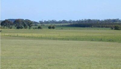
Location: Macarthur
Australian Soil Classification: Vertic, Eutrophic, Brown CHROMOSOL
General Landscape Description: Level Plain
Site Description: Flat
Land Unit: Warrakbook Basalts
Geology: Quaternary basalt
General Land Unit Description: This land unit consists of gently undulating basalt plains in the Macarthur area. In some drainage lines, the basalt has been dissected sufficiently to expose the underlying sediments. The soils on the basalt plains are commonly Brown Kurosols or Chromosols, intermixed with Sodosols, particularly on the lower slopes and drainage depressions.
Soil Profile Morphology
| A1 | 0-15 cm | Dark brown (10YR3/3) fine sandy clay loam; weak granular structure (10-20 mm) parting to weak granular structure (2-5 mm); very weak consistence when moderately moist; many medium roots; clear and smooth transition to:
| 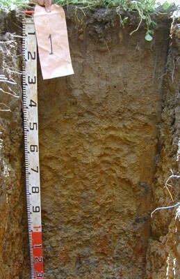 | |
| A2 | 15-35 cm | Brown (10YR5/3) fine sandy clay loam; weak polyhedral structure (20-50 mm) parting to weak granular structure (5-10 mm); very weak consistence when moist; common very fine macropores; areal porosity 0.5%; many medium roots; clear and smooth transition to:
| ||
| Subsoil
| ||||
| B1 | 35-45 cm | Brown (10YR5/3) with common medium faint light yellowish brown (10YR6/4) mottles, light clay; weak polyhedral structure (10-20 mm) parting to weak granular structure (5-10 mm); weak consistence when moist; common medium ferruginous nodules; few very fine macropores; areal porosity 0.05%; common fine roots; clear and smooth transition to:
| ||
| B21 | 45-90 cm | Yellowish brown (10YR5/4) with few medium distinct red (2.5YR4/8) light medium clay; moderate polyhedral structure (20-50 mm) parting to moderate granular structure (5- 10 mm); weak consistence when moist; few coarse ferruginous nodules; common very fine macropores; areal porosity 0.05%; few very fine roots; gradual and smooth transition to:
| ||
| B22 | 90-140 cm | Light brownish grey (10YR6/2) with few medium distinct yellowish brown (10YR5/4) and red (2.5YR4/6) mottles, medium clay; strong lenticular structure (20-50 mm) parting to strong polyhedral structure (10-20 mm); weak consistence when moist; few coarse ferruginous nodules; common very fine macropores; areal porosity 0.1%; few very fine roots.
| ||
| 140-340 cm | Roots observed to 270 cm, heavy grey clay, moderately strong lenticular structure.
| |||
| C | 340-420 cm | The C Horizon, extremely coarse weathered basalt (up to 1000 mm), live roots many medium roots observed. Basaltic rocks (up to 150 mm) observed. The abundance of rocks in increasing with depth with virtually all rock at 420 cm, resulting in an impeding layer to root growth.
| ||
Soil Profile Characteristics:
- | pH | Salinity | ||
Surface Soil (A1 horizon) | Very Strongly Acid | Low | Non-Sodic | None |
Subsoil (B21 Horizon) | Slightly Acid | Low | Non-Sodic | None |
Deeper Subsoil (80-140 cm) | Moderately Acid | Low | - | - |
Chemical and Physical Analysis:
Horizon | Horizon Depth (cm) | pH (water) | pH (CaCl2) | EC dS/m | Organic Carbon % | Total Nitrogen % | Exchangeable Acididty meq/100g | Exchangeable Cations | Coarse Sand (0.2-2.0 mm) % | Fine Sand (0.02-0.2 mm) % | Silt (0.002-0.02 mm) % | Clay (<0.002 mm) % | |||
Ca | Mg | K | Na | ||||||||||||
meq/100g | |||||||||||||||
A1 | 0-15 | 4.7 | 4.2 | 0.06 | 3.2 | 0.24 | 13 | 1.8 | 0.61 | 0.09 | 0.06 | 34 | 33 | 16 | 10 |
A2 | 15-35 | 5.7 | 5.0 | <0.05 | 6.2 | 2.0 | 1.4 | 0.06 | 0.10 | 32 | 34 | 15 | 18 | ||
B1 | 35-45 | 6.3 | 5.6 | 0.06 | 7.8 | 3.1 | 2.8 | 0.08 | 0.27 | 30 | 24 | 11 | 33 | ||
B21 | 45-80 | 6.1 | 5.8 | 0.14 | 10 | 3.4 | 5.8 | 0.14 | 1.0 | 16 | 15 | 8 | 61 | ||
B22 | 80-140 | 5.9 | 5.6 | 0.20 | |||||||||||
Profile Described By: Ian Sargeant, Paul Feikema, Martin Clark and Kiet Quach, 30th October 2000.
© State of Victoria (Agriculture Victoria) 1996 - 2025.

This work, Victorian Resources Online, is licensed under a Creative Commons Attribution 4.0 licence. You are free to re-use the work under that licence, on the condition that you credit the State of Victoria (Agriculture Victoria) as author, indicate if changes were made and comply with the other licence terms.
The licence does not apply to ‘branding’ or some ‘images or photographs’ that may be owned by third parties. We ask you to seek prior approval to use images using the VRO feedback form. Access to higher quality images can also be provided on request.
This page was last updated on 23/03/2020.