GHF09a
Location: Byaduk
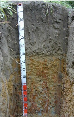
Australian Soil Classification: Melacic-Mottled, Eutrophic, Grey CHROMOSOL (thick sandy surface horizons)
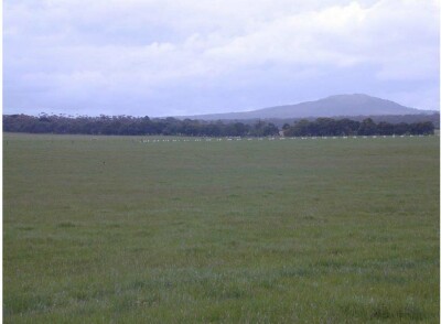
General Landscape Description: Level plain
Site Description: Flat
Land Unit: Warrabkook Basalts
Geology: Quaternary basalt
General Land Unit Description: This land unit consists of gently undulating basalt plains in the Macarthur area. In some drainage lines, the basalt has been dissected sufficiently to expose the underlying sediments. The soils on the basalt plains are commonly Brown Kurosols or Chormosols, intermixed with Sodosols, particularly on the lower slopes and drainage depressions. This site has two year old Eucalyptus globulus in a plantation on ex-agricultural land.

Soil Profile Morphology
| A1 | 0-22 cm | Very dark grey (10YR3/1); loamy sand; single grain structure; loose consistence, wet; pH 4.8; gradual and smooth change to: |  |
| A2 | 22-50 cm | Dark greyish brown (10YR4/2); loamy sand; single grain structure; loose consistence, pH 5.3; clear and smooth change to: | |
| A3 | 50-55 cm | Brown (10YR5/3); clayey sand; weak medium granular structure; very weak consistence, wet; contains common medium ferruginous nodules; pH 6.3; abrupt and smooth change to: | |
| Subsoil | |||
| B21 | 55-90 cm | Grey (10YR5/1), with common coarse distinct reddish yellow (7.5YR6/8) and red (2.5YR4/8) mottles; light medium clay; strong polyhedral medium structure, parting to strong fine granular structure; weak consistence, moderately moist; contains common very fine macropores; pH 6.3; diffuse and smooth change to: | |
| B22 | 90-150 cm | Brown (10YR7/1), with common very coarse prominent brownish yellow (10YR6/6) and red (2.5YR4/8) mottles; medium clay; strong very coarse vertical lenticular structure, parting to strong medium granular structure; weak consistence, moderately moist; pH 6.3; changes to: | |
| 150-300 cm | Clays with the odd sand pocket, similar to above; changes to: | ||
| 300-400 cm | Decomposing, soft and well aerated, vesicular basalt in a grey/yellow brown clay matrix. |
Key Profile Features:
- Strong texture contrast between sandy surface (A) horizons and clayey subsoil (B21)
- Thick sandy surface (A) horizons
Soil Profile Characteristics:
- | pH | Salinity | ||
Surface Soil (A1 horizon) | Very Strongly Acid | Very Low | Non-Sodic | None |
Subsoil (B21) | Slightly Acid | Very Low | Non-Sodic | None |
Deeper Subsoil (90-150 cm) | Slightly Acid | Very Low | Marginally Sodic | None |
Chemical and Physical Analysis:
Horizon | Horizon Depth (cm) | pH (water) | pH (CaCl2) | EC dS/m | Exchangeable Aluminium ppm | Exchangeable Acididty meq/100g | Exchangeable Cations | Coarse Sand (0.2-2.0 mm) % | Fine Sand (0.02-0.2 mm) % | Silt (0.002-0.02 mm) % | Clay (<0.002 mm) % | Field Capacity % w/w | Wilting Point % w/w | |||
Ca | Mg | K | Na | |||||||||||||
meq/100g | ||||||||||||||||
A1 | 0-22 | 4.8 | 4.1 | <0.05 | 50 | 1.1 | 0.28 | 0.06 | <0.05 | 29 | 23 | 9 | 8 | 9.4 | 2.8 | |
A2 | 22-50 | 5.3 | 4.6 | <0.05 | <10 | 0.80 | 0.24 | <0.05 | <0.05 | 62 | 22 | 9 | 7 | 7.9 | 1.9 | |
A3 | 50-55 | 6.3 | 5.5 | <0.05 | <10 | 2.4 | 2.5 | 0.07 | 0.11 | 49 | 17 | 7 | 37 | 14.7 | 8.7 | |
B21 | 55-90 | 6.3 | 5.9 | 0.12 | <10 | 6.9 | 3.3 | 5.4 | 0.12 | 0.67 | 32 | 11 | 7 | 52 | 26.9 | 17.0 |
B22 | 90-150 | 6.3 | 5.8 | 0.13 | <10 | 6.9 | 3.0 | 6.2 | 0.11 | 1.1 | 28 | 11 | 7 | 55 | 31.2 | 18.1 |
Profile Described By: Ian Sargeant, Paul Feikema and Martin Clark, 3rd November 2000.


