
GHF07c
Location: Mumbannar
Australian Soil Classification: Melacic-Parapanic, Humic/Humosesquic, Semiaquic, PODOSOL
General Landscape Description: Gently undulating plain
Site Description: Lower slope
Land Unit: Strathdownie
Geology: Quaternary lacustrine
General Land Unit Description: This land unit comprises the Quaternary lacustrine geology south of the Glenelg River. The lacustrine deposits include lagoonal, swamp and local colluvial deposits formed in low-lying wetlands and depressions between stranded beach ridges. Parent material in this land unit comprises of sand, silt, sandy clay, peat, marl and freshwater limestone, occurring in relatively unconsolidated forms.
The soils are variable throughout this land unit due to varying depositional environments. A common soil type is a strong texture contrast soil (Chromosol, Sodosol) commonly with a bleached A2 horizon and a mottled subsoil (indicative of impeded internal drainage). The sandy topsoil can be very deep in some soils. Vertosols are also common on the plains and swales in between the dunes. Podosols occur on the flats as well as on the dunes and that may have been mapped as part of this land unit due to restrictions of scale. Many of the soils are poorly drained and exhibit signs of a perched watertable.
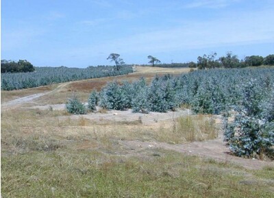
1.5 year old Eucalyptus globulus plantation on ex-agricultural land.
Soil Profile Morphology
| A1 | 0-20 cm | Very dark grey (10YR3/1); loamy fine sand; single grain structure; loose consistence, moist; many medium roots present; pH 4.7; clear and smooth change to:
| 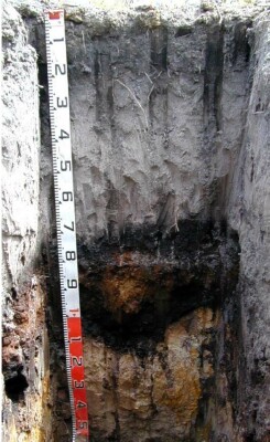 |
| A2 | 20-70 cm | Greyish brown (10YR5/2), conspicuously bleached; fine sand; single grain structure; loose consistence, moist; common very fine roots present; pH 4.6; abrupt and smooth change to:
| |
| Subsoil
| |||
| Bh | 70-80 cm | Black (10YR2/1); loamy fine sand; single grain structure; loose consistence, moist; many very fine roots present; pH 4.5; abrupt and smooth change to:
| |
| Bhs | 80-100 cm | Very dark brown (10YR2/2), with many coarse distinct strong brown (7.5YR5/6) mottles, loamy fine sand; massive structure; strong consistence, moderately moist; moderately cemented continuous massive organic pan evident; pH 4.6; abrupt and wavy change to:
| |
| B2 | 100-115 cm | Very pale brown (10YR7/3), with common fine dark yellowish brown (10YR4/4) and reddish yellow (7.5YR6/8) mottles; fine sandy clay; weak coarse angular blocky structure; very weak consistence, wet; pH 4.9; clear and wavy change to:
| |
| B3 | 115-150 cm | Very pale brown (10YR7/3), with common fine distinct reddish yellow (7.5YR6/8) mottles; clayey fine sand; single grain structure; loose consistence, wet; pH 6.2; changes to:
| |
| 150-200 cm | Sand; changes to:
| ||
| 200-250 cm | Sand; soft limestone (CaCO3) and limestone nodules present; changes to:
| ||
| 250-300 cm | Sand; increasing limestone with depth; becoming very hard and impenetrable at 300 cm.
| ||
| C | 300 + cm | Limestone. |
Soil Profile Characteristics:
- | pH | Salinity |
Surface Soil (A1 horizon) | Very Strongly Acid | Very Low |
Subsoil (70-80 cm) | Very Strongly Acid | Very Low |
Deeper Subsoil (115-150 cm) | Slightly Acid | Very Low |
Chemical and Physical Analysis:
Horizon | Horizon Depth (cm) | pH (water) | pH (CaCl2) | EC dS/m | Organic Carbon % | Total Nitrogen % |
A1 | 0-20 | 4.7 | 3.8 | <0.05 | 1.5 | 0.08 |
A2 | 20-70 | 4.6 | 3.8 | <0.05 | ||
Bh | 70-80 | 4.5 | 3.7 | <0.05 | 1.3 | 0.08 |
Bhs | 80-100 | 4.6 | 4.0 | <0.05 | ||
B2 | 100-115 | 4.9 | 4.1 | <0.05 | ||
B3 | 115-150 | 6.2 | 5.4 | 0.05 |
Management Considerations:
Free water at 150 cm and at 300 cm. The density of limestone at 300 cm suggests that there may be an impeding layer to root growth at this depth, but some data from Forestry SA indicates that the presence of shallow limestone may not necessarily restrict root development.
Profile Described By: Ian Sargeant, Paul Feikema, Martin Clark and Kiet Quach, 5th December 2000.
© State of Victoria (Agriculture Victoria) 1996 - 2025.

This work, Victorian Resources Online, is licensed under a Creative Commons Attribution 4.0 licence. You are free to re-use the work under that licence, on the condition that you credit the State of Victoria (Agriculture Victoria) as author, indicate if changes were made and comply with the other licence terms.
The licence does not apply to ‘branding’ or some ‘images or photographs’ that may be owned by third parties. We ask you to seek prior approval to use images using the VRO feedback form. Access to higher quality images can also be provided on request.
This page was last updated on 23/03/2020.