
GHF04a
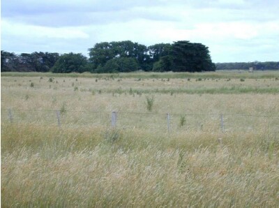
Location: Bessiebelle
Australian Soil Classification: Haplic, Epipedal, Aquic (Black) VERTOSOL
General Landscape Description: Plain
Site Description: Flat
Land Unit: Strathdownie
Geology: Quaternary lacustrine
General Land Unit Description: This land unit comprises the Quaternary lacustrine geology south of the Glenelg River. The lacustrine deposits include lagoonal, swamp and local colluvial deposits formed in low-lying wetlands and depressions between stranded beach ridges. Parent material in this land unit comprises of sand, silt, sandy clay, peat, marl and freshwater limestone, occurring in relatively unconsolidated forms.
The soils are variable throughout this land unit due to varying depositional environments. A common soil type is a strong texture contrast soil (Chromosol) commonly with a bleached A2 horizon and a mottled subsoil (indicative of impeded internal drainage). The sandy topsoil can be very deep in some soils. Vertosols are also common on the plains and swales in between the dunes. Podosols occur on the flats as well as on the dunes and that may have been mapped as part of this land unit due to restrictions of scale. Many of the soils are poorly drained and exhibit signs of a perched watertable.
Soil Profile Morphology
Surface
| A1 | 0-15 cm | Black (10YR2/1) medium clay; strong granular structure (5-10 mm); firm consistence when dry; few very fine macropores; areal porosity 0.02%; common very fine roots; clear and smooth transition to:
| 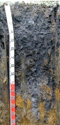 |
| Subsoil
| |||
| B21 | 15-65 cm | Black (10YR2/1), heavy clay; moderate polyhedral structure (50-100 mm) parting to moderate polyhedral structure (10-20 mm); weak consistence when moderately moist; few very fine macropores; areal porosity 0.02%; common very fine roots; gradual and smooth transition to:
| |
| B22 | 65-105 cm | Black (7.5YR2/0) heavy clay; strong prismatic structure (50-100 mm) parting to moderate prismatic structure (20-50 mm); weak consistence when moist; few very fine macropores; areal porosity 0.02%; common very fine roots; gradual and smooth transition to:
| |
| B23 | 105-150 cm | Yellowish brown (10YR5/8) with many very coarse prominent dark grey (7.5YR4/0) mottles, medium clay; moderate polyhedral structure (50-100 mm) parting to moderate granular structure (5-10 mm); weak consistence when wet; few very fine macropores; areal porosity 0.05%; few very fine roots.
| |
| 150-230 cm | Similar to layer above.
| ||
| 230-390 cm | Light grey and yellow and red brown mottled clay, light clay in mottles with a heavy clay matrix, there appears to be a perched watertable at about 230 cm, no roots observed. | ||
Soil Profile Characteristics:
- | pH | Salinity | ||
Surface Soil (A1 horizon) | Moderately Acid | Medium | Non-Sodic | None |
Subsoil (15-65 cm) | Slightly Acid | Low | Non-Sodic | None1 |
Deeper Subsoil (105-150 cm) | Slightly Acid | Low | Slightly Sodic | None1 |
Chemical and Physical Analysis:
Horizon | Horizon Depth (cm) | pH (water) | pH (CaCl2) | EC dS/m | Organic Carbon % | Total Nitrogen % | Exchangeable Aluminium ppm | Exchangeable Acididty meq/100g | Exchangeable Cations | Coarse Sand (0.2-2.0 mm) % | Fine Sand (0.02-0.2 mm) % | Silt (0.002-0.02 mm) % | Clay (<0.002 mm) % | Field Capacity % w/w | Wilting Point % w/w | |||
Ca | Mg | K | Na | |||||||||||||||
meq/100g | ||||||||||||||||||
A1 | 0-15 | 5.6 | 5.2 | 0.27 | 6 | 0.59 | 12 | 16 | 16 | 5.8 | 0.4 | 0.5 | 7 | 17 | 12 | 51 | 47.0 | 47.0 |
B21 | 15-65 | 6.7 | 5.9 | 0.13 | 9.9 | 13 | 7.5 | 0.24 | 1.3 | 6 | 20 | 14 | 59 | 40.2 | 40.2 | |||
B22 | 65-105 | 6.9 | 6.1 | 0.20 | 8.3 | 12 | 6.4 | 0.18 | 1.8 | 7 | 24 | 11 | 56 | 38.1 | 22.8 | |||
B23 | 105-150 | 6.8 | 6.3 | 0.23 | 6.5 | 7.7 | 4.5 | 0.20 | 1.3 | |||||||||
Profile Described By: Ian Sargeant and Paul Feikema (December 2000)
© State of Victoria (Agriculture Victoria) 1996 - 2025.

This work, Victorian Resources Online, is licensed under a Creative Commons Attribution 4.0 licence. You are free to re-use the work under that licence, on the condition that you credit the State of Victoria (Agriculture Victoria) as author, indicate if changes were made and comply with the other licence terms.
The licence does not apply to ‘branding’ or some ‘images or photographs’ that may be owned by third parties. We ask you to seek prior approval to use images using the VRO feedback form. Access to higher quality images can also be provided on request.
This page was last updated on 23/03/2020.