
CRC7
Location: Warrayure
Australian Soil Classification: Ferric, Mottled-Mesonatric, Grey SODOSOL (thick sandy surface horizon).
Site Description: Slight shelf at the edge of a depression.
Soil Profile Morphology:
Surface Soil
| A1 | 0-3 cm | Brown (7.5YR4/2); loamy sand; very weak consistence (dry); pH 5.8: | 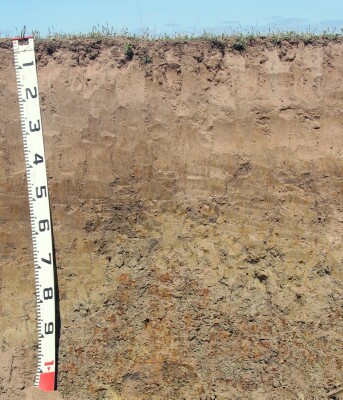 Site CRC7 Profile |
| A21 | 3-20 cm | Brown (10YR5/3); conspicuously bleached; sand; loose consistence (dry); pH 5.1: | |
| A22 | 20-30 cm | Brown (10YR5/3); conspicuously bleached (10YR7/2d); sand; very weak consistence (dry); pH 5.6: | |
| A23 | 30-40 cm | Brown (10YR5/3); conspicuously bleached; fine sand; weak to firm consistence (dry); pH 5.7: | |
| Subsoil | |||
| B1 | 40-50 cm | Brown (10YR5/3) with many brownish yellow (10YR6/8) mottles; sandy clay loam; moderate very coarse to coarse prismatic structure; firm consistence (slightly moist); pH 5.7: | |
| B21 | 50-80 cm | Light grey (10YR7/2) with many yellow (2.5Y7/6) mottles; sandy clay; strong very coarse to coarse prismatic, parting to strong coarse blocky structure; strong consistence (moderately moist); wavy change to; pH 6.4: | |
| B22c | 80-110 cm | Gravelly clay; very many (60%) ferruginous nodules and ferruginous sandstone (often conglomerated); pH 7.8. | |
Key Profile Features:
- Thick sandy surface horizons.
- Conspicuously bleached subsurface (A2) horizons.
- Strong texture contrast between surface (A) horizons and subsoil (B21) horizon.
Soil Profile Characteristics:
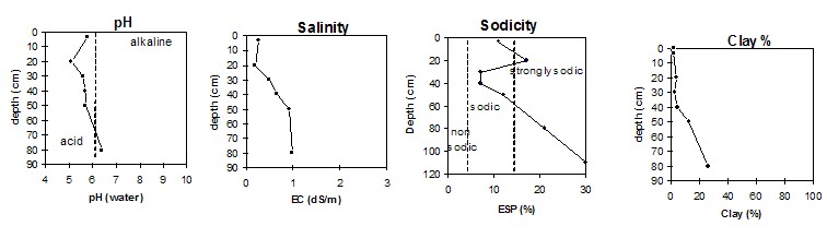
pH | Salinity Rating | |||
Surface (A1 horizon) | Moderately Acid | Medium | Non-Sodic | None |
Subsoil (B21 50-80 cm horizon) | Moderately Acid | Extremely High | Strongly Sodic | None1 |
Deeper subsoil (at 80-110 cm) | Slightly Alkaline | High | Strongly Sodic | Strong |
 |
Chemical and Physical Analysis:
Horizon | Horizon Depth (cm) | pH (water) | pH (CaCl2) | EC dS/m | NaCl | Exchangeable Aluminium ppm | Exchangeable Acididty meq/100g | Exchangeable Cations | Coarse Sand (0.2-2.0 mm) % | Fine Sand (0.02-0.2 mm) % | Silt (0.002-0.02 mm) % | Clay (<0.002 mm) % | Field Capacity % w/w | Wilting Point % w/w | |||
Ca | Mg | K | Na | ||||||||||||||
meq/100g | |||||||||||||||||
A1 | 0-3 | 5.8 | 5.3 | 0.27 | 0.07 | <10 | 2.8 | 1.5 | 0.9 | 0.1 | <0.1 | 47 | 46 | 3 | 2 | 10 | 6 |
A21 | 3-20 | 5.1 | 4.6 | 0.18 | <10 | 2.6 | 0.47 | 0.54 | 0.14 | 0.79 | 48 | 47 | 2 | 4 | 8 | 2 | |
A22 | 20-30 | 5.6 | 5.1 | 0.48 | <10 | 1.4 | 0.5 | 0.9 | <0.1 | 0.2 | 38 | 50 | 7 | 3 | 13 | 2 | |
A23 | 30-40 | 5.7 | 5.3 | 0.66 | 0.16 | <10 | 1.3 | 0.4 | 0.9 | <0.1 | 0.2 | 38 | 48 | 7 | 5 | 12 | 2 |
B1 | 40-50 | 5.7 | 5.2 | 0.92 | 0.21 | <10 | 3.2 | 0.7 | 2.9 | <0.1 | 0.9 | 36 | 42 | 7 | 13 | 18 | 6 |
B21 | 50-80 | 6.4 | 5.8 | 0.97 | 0.23 | <10 | 3.8 | 1.4 | 6.5 | 0.2 | 3.1 | 29 | 35 | 7 | 26 | 30 | 12 |
B22c | 80-110 | 7.8 | 6.8 | 0.50 | 0.09 | 2.2 | 9.7 | 5.1 | 5.1 | 40 | 19 | ||||||
Management Considerations:
Surface (A) Horizons
- The surface horizons are deep and sandy. Infiltration of water will be relatively rapid as a result and the surface soil will be well drained.
- The low wilting point in the surface horizons indicates that plants will be able to utilise very light rains when the soil is dry. However, due to the low water storage capacity, plants will soon suffer moisture stress unless further rain or watering occurs.
- The level of soluble salts is very high in the upper subsoil. This is likely to restrict the growth of deeper-rooted salt sensitive species.
- The dense and coarsely structured subsoil is strongly sodic and dispersive. This will result in restricted root and water movement into the subsoil. Waterlogging may occur in the overlying subsurface horizons.
- Root and water movement will also be restricted at depth in the deeper subsoil due to the large amount of ferruginous nodules and conglomerated sandstone.
© State of Victoria (Agriculture Victoria) 1996 - 2025.

This work, Victorian Resources Online, is licensed under a Creative Commons Attribution 4.0 licence. You are free to re-use the work under that licence, on the condition that you credit the State of Victoria (Agriculture Victoria) as author, indicate if changes were made and comply with the other licence terms.
The licence does not apply to ‘branding’ or some ‘images or photographs’ that may be owned by third parties. We ask you to seek prior approval to use images using the VRO feedback form. Access to higher quality images can also be provided on request.
This page was last updated on 23/03/2020.