
CRC5
Location: Warrayure
Australian Soil Classification: Natric, Dermosolic, Redoxic, HYDROSOL
Soil Profile Morphology:
Surface Soil
| A1 | 0-3 cm | Very dark brown (10YR2/2); fine sandy loam; weak consistence (dry); rusty root channel mottling; pH 6.3; abrupt change to: | 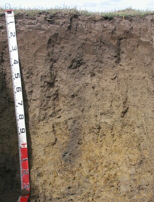 Site CRC5 Profile |
| A21 | 3-13 cm | Dark greyish brown (10YR4/2); sporadically bleached; fine sandy clay loam; weak consistence (dry); rusty root channel mottling; pH 5.9; clear change to: | |
| A22 | 13-25 cm | Dark greyish brown (10YR4/2); sandy clay loam; weak consistence (moist); rusty root channel mottling; pH 6.8; clear change to: | |
| Subsoil | |||
| B21 | 25-40 cm | Brown (10YR5/2); sandy clay; weak prismatic, parting to moderate coarse blocky structure (sand along some ped faces); weak consistence (moist); pH 7.5; gradual change to: | |
| B22 | 40-60 cm | Brown (10YR5/3); sandy clay; moderate to strong very coarse prismatic structure (sand along some ped faces); firm consistence (moist); pH 7.6: | |
| B23 | 60-80 cm | Greyish brown (10YR5/2) with brownish yellow (10YR6/8) mottles; light clay (sandy); moderate to strong very coarse prismatic structure; firm to very firm consistence (moderately moist) to strong consistence (dry); few (10%) ferro-manganiferous nodules (2-10 mm); pH 7.4: | |
| B24 | 80-100 cm | Pale brown (10YR6/3) with many brownish yellow (10YR6/8) mottles; light clay (sandy); firm consistence (moist); few (10%) ferro-manganiferous nodules (2-10 mm); pH 7.4: | |
| B25 | 100+ cm | Pale brown (10YR6/3) with many brownish yellow (10YR6/8) mottles; light medium clay (sandy); pH 7.2: |
Key Profile Features:
- Gradual increase in clay content (texture) down the profile.
Soil Profile Characteristics:
pH | Salinity Rating | |||
Surface (A1 horizon) | Slightly Acid | Extremely High | Sodic | None |
Subsoil (B21 horizon) | Slightly Alkaline | Very High | Strongly Sodic | Moderate-Complete |
Deeper subsoil (at 100+ cm) | Slightly Alkaline | Medium | Strongly Sodic | Complete |
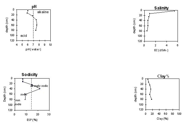 |
Chemical and Physical Analysis:
Horizon | Horizon Depth (cm) | pH (water) | pH (CaCl2) | EC dS/m | NaCl | Exchangeable Aluminium ppm | Exchangeable Acididty meq/100g | Exchangeable Cations | Coarse Sand (0.2-2.0 mm) % | Fine Sand (0.02-0.2 mm) % | Silt (0.002-0.02 mm) % | Clay (<0.002 mm) % | |||
Ca | Mg | K | Na | ||||||||||||
meq/100g | |||||||||||||||
A1 | 0-3 | 6.0 | 5.9 | 5.4 | 2.0 | <10 | 8.2 | 7.6 | 7.0 | 0.3 | 1.9 | 17 | 39 | 16 | 7 |
A21 | 3-13 | 5.9 | 5.4 | 0.93 | 0.26 | <10 | 3.6 | 2.2 | 2.4 | <0.1 | 0.6 | 33 | 43 | 9 | 9 |
A22 | 13-25 | 6.8 | 6.2 | 0.79 | 0.21 | <1.0 | 2.1 | 3.5 | <0.1 | 1.1 | 25 | 46 | 16 | 12 | |
B21 | 25-40 | 7.5 | 6.8 | 0.61 | 0.16 | 1.8 | 4.4 | 0.2 | 2.5 | 30 | 41 | 12 | 15 | ||
B22 | 40-60 | 7.6 | 6.9 | 0.63 | 0.16 | 2.1 | 5.3 | 0.3 | 2.6 | 28 | 41 | 17 | 12 | ||
B23 | 60-80 | 7.4 | 6.7 | 0.47 | 0.11 | 2.2 | 5.4 | 0.3 | 2.0 | 31 | 38 | 12 | 17 | ||
B24 | 80-100 | 7.4 | 6.6 | 0.29 | 0.07 | 2.2 | 5.4 | 0.3 | 1.6 | ||||||
B25 | 100+ | 7.4 | 6.4 | 0.34 | 0.08 | 2.1 | 5.2 | 0.3 | 1.8 | ||||||
Management Considerations:
Whole Profile
- Much of the soil profile is likely to be saturated for a number of months in most years.
- The level of soluble salts is extremely high in the surface horizon.
- The coarsely structured, strongly sodic and dispersive subsoil is likely to restrict root and water movement.
- The level of soluble salts is very high in the upper subsoil, and decreases down the profile.
© State of Victoria (Agriculture Victoria) 1996 - 2025.

This work, Victorian Resources Online, is licensed under a Creative Commons Attribution 4.0 licence. You are free to re-use the work under that licence, on the condition that you credit the State of Victoria (Agriculture Victoria) as author, indicate if changes were made and comply with the other licence terms.
The licence does not apply to ‘branding’ or some ‘images or photographs’ that may be owned by third parties. We ask you to seek prior approval to use images using the VRO feedback form. Access to higher quality images can also be provided on request.
This page was last updated on 23/03/2020.