
CRC2
Location: Murroa
Australian Soil Classification: Bleached-Ferric (& Reticulate), Eutrophic, Yellow CHROMOSOL
General Landscape Description: Low rises
Site Description: Upper slope of low rise
Geology: Tertiary/Quaternary basalt.
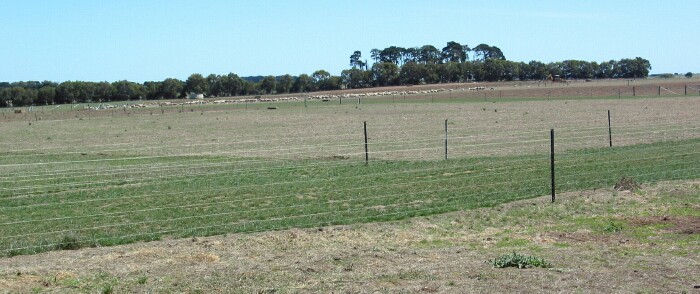 Site CRC2 Landscape |
Soil Profile Morphology:
Surface Soil
| A1 | 0-10 cm | Dark brown (10YR3/3); fine sandy clay loam (slightly spongy); weak coarse blocky, parting to moderate blocky structure; firm consistence (dry); ferruginous nodules (2-8 mm) common (20%); pH 6.3: | 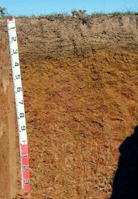 Site CRC2 Profile |
| A2c | 10-25 cm | Dark yellowish brown (10YR4/4) (10YR6/4 dry); fine sandy clay loam; very many (50%) ferruginous nodules (2-15 mm); ferromanganiferous (magnetic) nodules; pH 5.6: | |
| Subsoil | |||
| B21 | 25-35 cm | Yellowish brown (10YR5/6); light clay (subplastic); weak medium blocky, parting to moderate-strong medium to fine polyhedral structure; very firm consistence (moist) to strong consistence (dry); ferruginous nodules (2-10 mm) are common (20%); pH 6.2: | |
| B22 | 35-50 cm | Reddish yellow (7.5YR6/8) with few dark red (2.5YR4/8) mottles; light medium clay; strong coarse to medium polyhedral structure; very firm consistence (moist) to strong consistence (dry); few (5%) ferruginous nodules; pH 6.5; gradual change to: | |
| B23 | 50-100 cm | Reddish yellow (7.5YR6/8) with many (50%) dark red (2.5YR4/8) mottles; medium clay; strong coarse to medium polyhedral, parting to fine polyhedral structure (shiny-faced peds); very firm consistence (moist); few ferruginous nodules (2-5 mm); pH 6.3; gradual change to: | |
| B24 | 100-140+ cm | Light yellowish brown (2.5Y6/4) with many dark red (2.5YR4/8) and light grey (10YR7/1) mottles (reticulated mottling); medium clay; strong medium to coarse polyhedral, parting to fine polyhedral structure (shiny-faced peds); with nests of lenticular structure; very firm consistence (dry); pH 6.2. | |
Key Profile Features:
- Strong texture contrast between surface (A) horizons and subsoil (B) horizons.
- Many ferruginous nodules in the subsurface (A2) horizon.
Soil Profile Characteristics:
pH | Salinity Rating | |||
Surface (A1 horizon) | Strongly Acid | Low | Non-Sodic | None |
Subsoil (B21c horizon) | Slightly Acid | Very Low | Non-Sodic | None |
Deeper subsoil (at 100-140+ cm) | Slightly Acid | Very Low | Marginally Sodic | None |
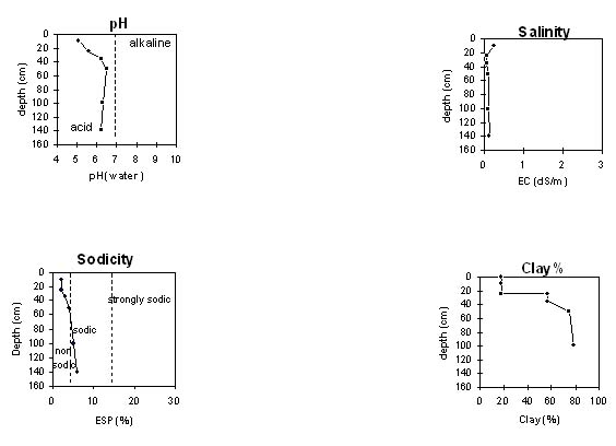 |
Chemical and Physical Analysis:
Horizon | Horizon Depth (cm) | pH (water) | pH (CaCl2) | EC dS/m | Exchangeable Aluminium ppm | Exchangeable Acididty meq/100g | Exchangeable Cations | Coarse Sand (0.2-2.0 mm) % | Fine Sand (0.02-0.2 mm) % | Silt (0.002-0.02 mm) % | Clay (<0.002 mm) % | Field Capacity % w/w | Wilting Point % w/w | |||
Ca | Mg | K | Na | |||||||||||||
meq/100g | ||||||||||||||||
A1 | 0-10 | 5.1 | 4.7 | 0.25 | 35 | 17 | 4.6 | 1.6 | 1.0 | 0.51 | 12 | 33 | 22 | 19 | 35 | 15 |
A2c | 10-25 | 5.6 | 4.9 | 0.06 | 16 | 8.8 | 3.4 | 1.6 | 0.21 | 0.35 | 24 | 32 | 21 | 18 | 25 | 10 |
B21c | 25-35 | 6.2 | 5.6 | 0.08 | <10 | 9.7 | 4.2 | 4 | 0.15 | 0.58 | 9 | 19 | 11 | 57 | 33 | 22 |
B22 | 35-50 | 6.5 | 6.2 | 0.11 | 11 | 4.6 | 5.4 | 0.16 | 0.87 | 2 | 8 | 11 | 75 | 42 | 31 | |
B23 | 50-100 | 6.3 | 6.1 | 0.13 | <10 | 9.3 | 4.1 | 5.7 | 0.12 | 1 | 3 | 8 | 8 | 79 | 43 | 32 |
B24 | 100-140+ | 6.2 | 6.1 | 0.14 | <10 | 9.0 | 3.5 | 7.1 | 0.11 | 1.2 | 3 | 10 | 13 | 75 | ||
Management Considerations:
Surface (A) Horizons
- The surface soil (upper 10 cm) is strongly acid which indicates that aluminium and manganese toxicity may occur. The level of exchangeable aluminium measured at this site is in the low range i.e. 35 mg/kg. However, a pH/aluminium test is best performed from samples taken across the paddock and bulked together. Other factors also need to be considered before lime is recommended e.g. pasture species grown, method of application, local trial responses, soil surface structure and likely cost/benefit.
- The upper subsoil is non-sodic and well structured, parting to fine polyhedral aggregates. This will be conducive to root and water movement, although the strong texture contrast will provide some restrictions.
Profile Described By: Mark Imhof, Austin Brown, Darren Bennetts and Malcolm McCaskill, March 2003.
© State of Victoria (Agriculture Victoria) 1996 - 2025.

This work, Victorian Resources Online, is licensed under a Creative Commons Attribution 4.0 licence. You are free to re-use the work under that licence, on the condition that you credit the State of Victoria (Agriculture Victoria) as author, indicate if changes were made and comply with the other licence terms.
The licence does not apply to ‘branding’ or some ‘images or photographs’ that may be owned by third parties. We ask you to seek prior approval to use images using the VRO feedback form. Access to higher quality images can also be provided on request.
This page was last updated on 23/03/2020.