
Mount Warrnambool
|
This information has been obtained from the report: Eruption Points of the Newer Volcanic Province of Victoria by Neville Rosengren. This report was published in 1994 and was prepared for the National Trust of Australia (Victoria) and the Geological Society of Australia (Victorian Division). The review of eruption points was based on an earlier unpublished manuscript Catalogue of the post-Miocene volcanoes of Victoria compiled by O P Singleton and E B Joyce (Geology Department, University of Melbourne 1970). |
| Location: | 38 18 30S 142 44 30E (external link); 7421-3-1 (Cudgee) 520587. 16 km SW of Terang. Princes Highway, Warrnambool. | 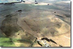 Mt Warrnambool. |
Land Tenure/Use: | Private land. Bare, grazing, limited outcrop on lower slopes. Small parcel of public land at summit. Fire tower access track to summit not open to public. Quarry in south-eastern side of tuff ring. | |
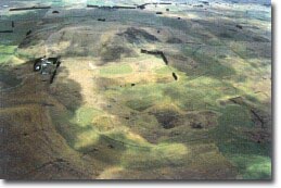
Type 8: | Nested tuff ring and maar with scoria cone. | |
Mount Warrnambool is a single large scoria cone about 1 km in diameter nested inside a tuff ring over 3 km diameter. The cone has a broad, flattened summit with a shallow crater open to the north and partly surrounded by a squeeze-up rim of steeply dipping lava. Other thin lava ridges occur on the slopes of the cone. Hummocks on the summit area and slopes may be small parasitic lava eruption points. An irregular ring of tuff up to 15 m high encloses the northern and eastern sides of the maar crater of Mount Warrnambool. Elsewhere the tuff has been covered by lava flows. It is exposed in a small quarry on the southern edge of the tuff ring north of the Princes Highway which reveals well-bedded airfall deposits with minor base surge and bomb sag structures. This tuff is unusually hard or indurated and requires blasting in the quarry. Although not directly dated, K-Ar ages on basalts below and above tuff materials have given a range of 2.2 million years to 570,000 years for the eruption. | ||
216 m; 105 m. | ||
Regional: | The site is an outstanding example of complex volcanic activity featuring lava flows, a maar eruption and Strombolian-type activity. The scoria cone displays a variety of pyroclastics including very good exposures of an unusually hardened tuff deposit. The site has had varied interpretation and makes an interesting study in the development of ideas concerning maar formation. | |
Class 2: | Limited quarrying of the maar is useful as it exposes very clear sections of tuff bedding structures. As yet, there is no quarry on the scoria cone. If this was to occur, detailed site plans would be required to avoid removing the important linear squeeze-up lava structures or the small lobes of lava. | |
References: | Gill, E.D. 1950. An hypothesis relative to the age of some Western District volcanoes, Victoria. Proceedings of the Royal Society of Victoria 60, pp. 189-194. Ollier, C.D. & Joyce, E.B. 1964. Volcanic physiography of the Western Plains of Victoria. Proceedings of the Royal Society of Victoria 77, pp. 357-376. Edwards, J. 1991b. Geology of the Cudgee 1:25 000 map, Port Campbell Embayment, East Otway Basin, Victoria. Geological Survey of Victoria Unpublished Report 1991/5. Guerin, B. 1992. Review of scoria and tuff quarrying in Victoria. Geological Survey of Victoria Report 96. | |
|
© State of Victoria (Agriculture Victoria) 1996 - .

This work, Victorian Resources Online, is licensed under a Creative Commons Attribution 4.0 licence. You are free to re-use the work under that licence, on the condition that you credit the State of Victoria (Agriculture Victoria) as author, indicate if changes were made and comply with the other licence terms.
The licence does not apply to ‘branding’ or some ‘images or photographs’ that may be owned by third parties. We ask you to seek prior approval to use images using the VRO feedback form. Access to higher quality images can also be provided on request.
This page was last updated on .