
Tower Hill
|
This information has been obtained from the report: Eruption Points of the Newer Volcanic Province of Victoria by Neville Rosengren. This report was published in 1994 and was prepared for the National Trust of Australia (Victoria) and the Geological Society of Australia (Victorian Division). The review of eruption points was based on an earlier unpublished manuscript Catalogue of the post-Miocene volcanoes of Victoria compiled by O P Singleton and E B Joyce (Geology Department, University of Melbourne 1970). |
| Location: | 30 19 00S 142 22 00E (external link); 73212-4 (Koroit) 187575. 1 km S of Koroit and 13 km NW of Warrnambool. Princes Highway. | 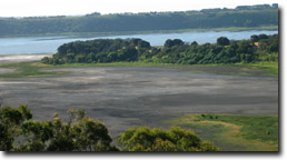 View over Tower Hill complex |
Koroit (Borough) | ||
| Land Tenure/Use: | Public land (Tower Hill State Game Reserve). Visitor Information Centres, extensive tree planting. Some private land around rim. One operating quarry near rim on south-eastern side and smaller abandoned pits inside rim on public land. | |
Type 8: | Nested Maar. Tower Hill is one of the largest eruption points of the Pleistocene Newer Volcanics Province of Victoria. It is a complex volcanic centre comprising a main crater 3.2 km x 2.4 km with a surrounding tuff ring. The inner walls of the tuff ring are steep and enclose a flat-topped crater over 90 m deep. Much of the crater is covered by a shallow lake. Disused quarries in the tuff ring reveal complex bedding structures and a range of pyroclastic materials (ash, lapilli, coarse scoria and volcanic blocks and bombs). The whole structure has been variously interpreted as either an explosion or collapsed caldera, or a maar. However, it appears that most of the fine-grained material and the crater were created by phreatomagmatic eruptions with ash being dispersed over a wide area. Nested inside the main maar of Tower Hill are ten scoria cones or mounds resulting from later eruptions. These include three well-defined, swampy craters. There have been several attempts to determine the eruption chronology of Tower Hill e.g. by thermoluminescence dates on the scoria, by radiocarbon dating of materials buried by the ash, and by dating and pollen analysis of sedimentary and organic material from the floor of the maar and the nested craters. The most recent work suggests that the eruption was pre-Holocene, being close to 20 000 years ago rather than the 7 000 years suggested by earlier work. | |
90+ m; 90 m. | ||
International: | Because of its deep and circular crater form, Tower Hill is one of the most obvious young volcanic features in Australia and one of the largest maars in the world. The complex nature of its formation is of considerable geological interest. There are only a small number of maars in the Newer Volcanics Province and Tower Hill provides a type example of a nested maar. There is an excellent record of eruptive sequences and depositional history of pyroclastics in the tuff beds exposed on the rim of the maar. The numerous nested craters and mounds are important in illustrating the multiple stages of volcanism here and provide material suitable for dating the most recent stage of activity. The craters contain an important palynological record. Although the age of eruption is probably pre-Holocene, it is one of the most recently active volcanoes in Victoria. It is an outstanding teaching and research site and well suited for public access and interpretation. | |
Class 2: | The site is adequately managed as public land. The old quarry exposures should be monitored to assess the condition of the exposure. There may need to be occasional excavation or cleaning of debris from some faces to maintain the clarity of the exposures of pyroclastic deposits. | |
References: | Gill, E.D. 1978. Radiocarbon dating of the volcanoes of western Victoria, Australia. Victorian Naturalist 95, pp. 152-158. Orth, K. 1988. Warrnambool 1:50 000 map geological report. Geological Survey of Victoria Report 86. D’Costa, D., Edney, P.A., Kershaw, A.P. & DeDeckker, P. 1989. Late Quaternary palaeoecology of Tower Hill, western Victoria, Australia. Australian Journal of Biogeography 16, pp. 461-482. 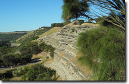 Exposed tuff beds on the rim of Maar. | |
© State of Victoria (Agriculture Victoria) 1996 - .

This work, Victorian Resources Online, is licensed under a Creative Commons Attribution 4.0 licence. You are free to re-use the work under that licence, on the condition that you credit the State of Victoria (Agriculture Victoria) as author, indicate if changes were made and comply with the other licence terms.
The licence does not apply to ‘branding’ or some ‘images or photographs’ that may be owned by third parties. We ask you to seek prior approval to use images using the VRO feedback form. Access to higher quality images can also be provided on request.
This page was last updated on .