
Mount Noorat
|
This information has been obtained from the report: Eruption Points of the Newer Volcanic Province of Victoria by Neville Rosengren. This report was published in 1994 and was prepared for the National Trust of Australia (Victoria) and the Geological Society of Australia (Victorian Division). The review of eruption points was based on an earlier unpublished manuscript Catalogue of the post-Miocene volcanoes of Victoria compiled by O P Singleton and E B Joyce (Geology Department, University of Melbourne 1970). |
| Location: | 38 11 00S 142 56 00E (external link); 7421-1-2 (Terang) 695726. 6 km N of Terang. Glenormiston Road, Hampden. |
A 'virtual aerial tour' of Mt. Noorat
A 'virtual aerial tour' of Mt. Noorat is provided in this video clip. This video runs for 46 seconds and is 4.6 MB in size.
| Click the 'play' button and the video should display directly in your browser if this does not happen you may need to update the 'Adobe Flash Player'. This free software can be downloaded from the Adobe website (external link. |
Land Tenure/Use: | Private Land. Grazing land use as well as three operating quarries on the western side and a disused pit on the south, at the Noorat township. | ||
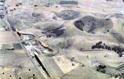
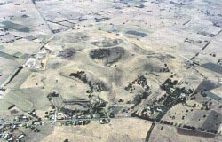
Type 5: | Multiple scoria cones with craters. Mount Noorat is a scoria cone with complex eruption point topography. The central feature of the volcano is an entire circular crater with a minimum enclosure depth of 85 m. The base of this crater (150+ m) is lower than the level of the surrounding plain. The highest point on the crater rim is a mound of scoria reaching a height of 310 m ASL. The upper crater rim is of welded spatter and lies at a very steep angle. Surrounding the main crater are a number of mounds and depressions which are probably other eruption points, the most obvious being a partly enclosed depression on the northern side. The lowermost materials exposed in the western quarries are tuff deposits indicating an initial maar eruption. Subsequent scoria eruptions have almost completely buried the tuff which rests on basalt lava flows. There are some excellent geological sections exposing scoria draped over tuff beds in the lower western quarries. Mount Noorat is a major locality for Cr-diopside lherzolite series xenoliths. 310 m; 160 m. | ||
International: | Mount Noorat is one of the major volcanoes of the Newer Volcanics Province of Victoria. It is has multiple vents, complex topography, the deepest scoria enclosed crater in Victoria (and possibly Australia) and illustrates a transition form maar eruption to scoria cone development. It was proposed by Ollier (1967a) as the type locality of the “Noorat” type scoria cone. It is a major megacryst and xenolith locality. | ||
Class 1: | Although a large locality, the complexity of the topography makes this a sensitive region. Presently, quarrying is confined to the western side but the EIL 1042 scoria pit is a source of major physical disruption as it extends high into the western wall of the mains scoria cone. Extension of this will compromise the physical integrity of the slopes of this cone. Even the present working area will endow a lasting disruptive change to physiography of the mountain. If the significance of the site is to be maintained, this activity will need to be relocated to lower slopes further away from the main cone. The lower pits are less intrusive and provide instructive sections through the tuff/scoria contact. Parts of these lower exposures should be preserved for interpretation. This site requires further investigation and planning to rationalise the use of the resources. Public access to the summit and crater should be available. | ||
References: | Grayson, H.J. & Mahony, D.J. 1910. The geology of the Camperdown and Mount Elephant Districts. Geological Survey of Victoria Memoir 9. Hills, E.S. 1940. The physiography of Victoria (1st edn). Whitecombe & Tombs, Melbourne. Ollier, C.D. & Joyce, E.B. 1964. Volcanic physiography of the Western Plains of Victoria. Proceedings of the Royal Society of Victoria 77, pp. 357-376. Ollier, C.D. 1967a. Landforms of the Newer Volcanics Province of Victoria. In J.N. Jennings & J.A. Mabbutt (eds). Landform studies from Australia and New Guinea. ANU Press. pp. 315-339. Irving, A.J. 1974. Megacrysts from the Newer Basalts and other basaltic rocks of southeastern Australia. Geological Society of America Bulletin 85, pp. 1503-1514. Irving, A.J. & Green, D.H. 1976. Geochemistry and petrogenesis of the Newer Basalts of Victoria and South Australia. Journal of the Geological Society of Australia 23(1), pp. 45-66. | ||
|
Additional Information on VRO
Soil pit sites in the Mt Noorat area
© State of Victoria (Agriculture Victoria) 1996 - .

This work, Victorian Resources Online, is licensed under a Creative Commons Attribution 4.0 licence. You are free to re-use the work under that licence, on the condition that you credit the State of Victoria (Agriculture Victoria) as author, indicate if changes were made and comply with the other licence terms.
The licence does not apply to ‘branding’ or some ‘images or photographs’ that may be owned by third parties. We ask you to seek prior approval to use images using the VRO feedback form. Access to higher quality images can also be provided on request.
This page was last updated on .