
Programs in the Ararat Hills
Landmate | Phascogale | National Action Plan for Salinity Grants | Evergraze | Landscape Protection Programs
Landmate provides a helping hand
In the 2007/08 financial year, HM Prison Langi Kal Kal is again offering the services of a 6-8 man team to help out on environmental projects within a 50-70 km radius of Langi Kal Kal. The team is accessed free of charge and is supervised by a prison officer.
Some of the activities that the team was involved in for 2006/07 were: planting over 12,000 trees and shrubs, clearing over 9 km of fences burned in the recent fires, erecting 27.5 km of new fencing and controlling weeds (mainly gorse) on 31 ha of land. The team is to be congratulated on such a terrific effort helping the community.
The team is operated by a roster system where a landholder requests a number of days, specifies the type of job required and specifies a place to meet. It is expected that the landholder will be on site to assist and that all materials are organised and ready for use on the day. The prison officer will contact the landholder prior to arriving, to confirm the job details.
For fencing jobs, the expectation is that all stays will have been erected prior to the crew arriving. The crew can drive steel posts, attach wire to posts and attach droppers. Fence clearing has been limited to those landholders who have lost fencing because of bushfires.
Landholders who access DPI Salinity Incentive grants or CMA Partnership Project grants are also able to access assistance from Landmate if they are within range of Langi Kal Kal. For more information and to book a date for the Landmate crew, phone Ruth Raleigh on (03) 55 730 713.
Search for the elusive Phascogale
| In the 2007/08 financial year, extension services to the Ararat Hills - Beaufort region will include biodiversity management, specifically monitoring for Brush-tailed Phascogale (Phascogale tapoatafa), also known as Tuan. This feisty little mammal is a threatened species (external site) and is listed as “vulnerable” by the (former) Department of Sustainability and Environment. Much of the Tuan’s life is spent foraging at night on the trunks and amongst the branches of rough-barked trees for large insects, spiders and centipedes. Female Brush-tailed Phascogales have home ranges of 30–60 ha and the males use areas greater than 100 ha. Males all die after mating, while females die shortly after weaning their young. This breeding strategy makes the species vulnerable to local extinctions. The characteristic black “bottlebrush” tail makes up half the length of the Phascogale with adults growing to just over 40 cm. The male is heavier at 230 g while the smaller females weigh 156 g. The animal has grey fur with large, naked ears and pale cream fur underneath. More information on the Brush-tailed Phascogale (external site) can be found about on the Australian Museum website. Central to the Brush-tailed Phascogale’s vulnerability is loss of habitat and tree hollows, and predation by foxes and roaming cats. A central objective of this monitoring program is to determine the distribution and abundance of the Brush-tailed Phascogale in the Ararat-Beaufort region on privately owned land. Monitoring will take the form of hair-tubes where a sample of hair is left on a sticky surface of the “trap” when the animal tries to steal a prepared treat. These hairs can be examined in the laboratory to determine what species they belong to. | 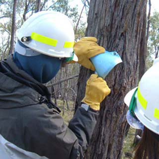 DSE staff and students place hair-tubes for monitoring Brush-tailed Phascogales (Photo: Ruth Raleigh) |
Another aspect of this program are grants of $1.80/m for fencing to protect habitat and prevent over-grazing. Grants also provide $0.80 per tree/shrub to those wishing to create new or enhance existing habitat, or to create wildlife corridors/shelterbelts.
In June, students from Canada and the USA helped DSE staff place hair-tubes for monitoring Brush-tailed Phascogales. The day was spent on public land in the Beaufort area and was part of an on-going monitoring program.
If you would like to volunteer your property to be part of an extended Phascogale monitoring program Please contact Ruth Raleigh on (55)730713 or ruth.raleigh@dpi.vic.gov.au . Ruth will also visit you and help with the paperwork if you would like to investigate applying for a grant.
Related Links
More information on the Brush-tailed Phascogale can be found on the following websites:
- Bird: Linking the Biodiversity Community (external link)
- Vicnet - Brush-tailed Phascogale Fact Sheet (external link)
- Unique Australian Animals website (external link)
Page Top
National Action Plan for Salinity Grants
In the 2007/08 financial year, grants are again available to landholders for controlling the effects of salinity and managing land to reduce recharge. Activities that can be funded are tree plantations using indigenous or farm forestry species (not pine or bluegum), lucerne establishment, saline agronomy, landclass fencing and fencing for protecting remnant vegetation. Fencing hill-tops to improve management of grazing can be funded as it helps to maintain ground-cover on the hills during summer.
A (former) DPI project officer will inspect the site and provide technical advice. The officer will also help to fill out the grant application form and can provide on-going advice until the project is completed. The grant is administered by the GHCMA with 80% of funds provided upfront and the final 20% paid when photographs of the work are presented.
Grants are targeted at subcatchments in the GHCMA area that are identified in the GHCMA Salinity Plan as priority catchments for on-ground works. Most of the Ararat Hills – Beaufort area is eligible for grants for either recharge or discharge management activities.
Landholders who access (former) DPI Salinity Incentive grants are also able to access free assistance from Landmate if they are within range of Langi Kal Kal. Landmate can provide labour for fencing and tree-planting. For more information and to book a date for the Landmate crew, phone Ruth Raleigh, DPI Hamilton on (03) 55 730 900.
Related Links
- Information notes on Salinity can be found on the DPI website
Page Top
EverGraze Low Input - native vegetation in harsh environments to improve profitability, sustainability and biodiversity
 Photo caption: Typical hill pasture with a proportion of native species in central Victoria. | DPI is funding a new research project to utilise native grasses in harsh environments such as steep hills for improved profitability, sustainability and biodiversity. ‘EverGraze Low Input on native vegetation’, is part of the national EverGraze program, which aims to increase farm profitability by 50% and considerably reduce recharge. The project has been developed based on research findings from the ‘Sustainable farming systems for steep hills’ undertaken by DPI researcher in central Victoria over the past five years. A series of deferred grazing strategies were identified by the steep hills project, which can significantly increase groundcover by perennial species and pasture composition and production, and reduce water and nutrient runoff. Deferred grazing involves no defoliation (e.g. grazing) of pasture for some months to encourage seed set of desirable perennial grasses. |
The objectives of the new project are to maintain a high level of perennial (mostly native) pastures through a combination of grazing and other management techniques (e.g. deferred grazing, rotational grazing, set stocking and use of fertiliser etc.) and to maximise pasture utilisation by grazing animals. Maintaining high levels of perennial native vegetation is also critical to sustain the ecological balance in these marginal land classes. The project team has assessed potential research and demonstration sites in collaboration with landholders around Ararat. Selected sites will be fenced off and initial deferred grazing management applied in spring 2007. Further treatments will be imposed in subsequent years. For further information about this new project contact Dr Zhongnan Nie or Reto Zollinger at DPI Hamilton Centre Phone 03 55730900. | |
 |
|
page top
Landscape Protection Programs
Rabbit target areas developed for 2007/08
The Rabbit target area developed for the 2007/08 financial year built on the significant gains made through rabbit control in the Glenelg Hopkins CMA in recent years. It also lays the foundations for other Natural Resource Management (NRM) projects.
The target area around Beaufort consisted of 120 properties based on the GHCMA Rabbit Action Plan identifying this area as being under long term control for rabbits. Long term control means that rabbit populations are at a level of 1 active entrance per 5 hectares of arable land. Landscape Protection staff completed property inspections and provided extension and technical advice to land owners. A common date was set for all landowners within the targeted area to complete any required control works, with requests being issued in the form of “Direction Notices”.
This group inspection method effectively completes a large number of inspections over a short period of time. It results in uniform time frames and expectations of all landowners in the area.
During a four-day period in November, 120 properties were inspected, involving nine Pest Management Officers. An area covering 14,000 hectares was assessed for rabbit activity. Fourteen Direction Notices were issued on properties, to ensure that control work was completed.
DPI successfully prosecuted a case of a landowner failing to comply with a Direction Notice in relation to Rabbit control associated with the 2006/07 Beaufort program. The landholder was subsequently fined. The 06-07 target area is completed with 100% compliance achieved. DPI has noticed an improved attitude from the community in relation to compliance.
Woody Weeds War on Waterways project
| The Woody Weeds War on Waterways project led to a significant amount of Gorse removed or treated in riparian areas of the Upper Hopkins over the last few years. This project has been responsible for opening up large areas of waterways, to allow activities such as revegetation and protective fencing funded through GHCMA “Partnerships Projects”. A compliance audit consisted of Landscape Protection staff inspecting properties previously infested with Woody Weeds. Notices under the Catchment and Land Protection Act were issued where works had not been maintained. Follow-up control of Gorse was required on only 16 properties bordering the Hopkins River, Fiery, Denicull, Jackson’s, Middle and Good Morning Bill Creeks. Over 70 properties and 24,000 hectares were involved in the program. This auditing project provides useful information regarding the number of landowners in the area who have continued to manage their riparian weeds after (former) DPI staff have moved on to other areas. | 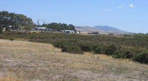 Gorse plants |
Upper-Mount Emu Creek Gorse project
The Upper-Mount Emu Creek Landcare Network Gorse project area, consists of 70 properties and covers over 10,000 hectares. It extends from Trawalla to Brewster and Carngham. The project focussed on Gorse control on riparian land adjoining the Mount Emu, Yam Holes, Reedy and Spring Hill Creeks. Crown land, both licensed and unlicensed, exists along sections of the Mount Emu Creek and was included. Initial inspections determined that approximately 12 hectares of private and crown land was infested with Gorse. Of ten Direction notices issued, extensive gorse control was conducted for five, with a two hectare area on crown land groomed to facilitate other control options.
Serrated Tussock in the Ararat Hills
Four Serrated Tussock sites are known within the Ararat Hills area. Three are located on the Railway Reserve between Ararat and Beaufort where no plants have been observed on the most recent inspection. The fourth site is on Road Reserve managed by VicRoads north of Maroona and is about 20 metres by 100 metres long. This site has been successfully controlled.
© State of Victoria (Agriculture Victoria) 1996 - 2025.

This work, Victorian Resources Online, is licensed under a Creative Commons Attribution 4.0 licence. You are free to re-use the work under that licence, on the condition that you credit the State of Victoria (Agriculture Victoria) as author, indicate if changes were made and comply with the other licence terms.
The licence does not apply to ‘branding’ or some ‘images or photographs’ that may be owned by third parties. We ask you to seek prior approval to use images using the VRO feedback form. Access to higher quality images can also be provided on request.
This page was last updated on 23/03/2020.