
Land Degradation Near Dookie
S.C. Boucher.
School of Geography and Environmental Science.
Monash University, 3800 Victoria.
This article is a summary historical document about the pioneering research work on land degradation by R.G. Downes from the mid-to-late 1940's around the Dookie area in north-eastern Victoria. Unquestionably the material is old and much of the incidence of erosion will have changed, but the extent and density of erosion at the time is worth noting. Furthermore, Downes made attempts to explain the origin of tunnel and other forms of erosion in Victoria in the context of the environmental changes wrought by European settlement.
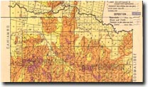
The area in question is located in the central-east part of the Goulburn-Broken CMA, near Violet Town. Whilst much of the mapped area was eroded by sheet, gully and tunnel erosion, degradation was most severe on land south of Broken River, especially in the Parishes of Caniambo and Gowangardie where the annual average rainfall was approximately 20-25” i.e. 508 – 635 mm (Downes 1949, Figure 2). A subset from a map of land degradation in the latter area has been scanned from the original 1949 report and reproduced below. Tunnel, sheet and gully erosion were evident with the latter two forms having been graded in severity.
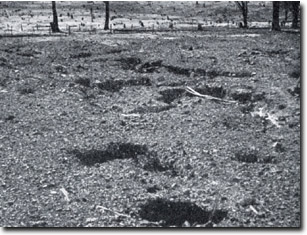 Tunnel erosion in the County of Moira (Downes 1946). |
The rainfall pattern was winter-dominant with most rain falling between April and October. The summers were generally hot, dry and interspersed with rainfall “… irregularly distributed in large amounts” (Downes 1949, 12). These summer rains together with the autumn seasonal break were suggested to be responsible for water erosion. The soil tended to dry and crack to a depth of 2-3’ i.e. 60-90 cm, enhancing the potential for tunnels to form. Tunnels were located in the B1 horizon, samples of which dispersed more than those from the other horizons (Downes and Leeper 1940, Downes 1946). The land was selected and cleared from approximately 1870 onwards. Clearing of most of the Eucalyptus spp. trees (particularly E. hemiphloia i.e. grey box) left native grasses such as Danthonia and Stipa spp. that were overgrazed by kangaroos, rabbits and sheep. Further details were provided by Downes (1958, 1974). The minimum slope steepness for tunnel erosion to occur was approximately 4o. |
Caniambo
Soil erosion in the Parish of Caniambo was not mapped by Downes in his 1949 study. The following soil data for Caniambo were sourced from Downes (1946, 1949) as presented in the article on tunnel erosion by Boucher (2003a). M. Imhof (pers. comm.) classified the following soil profile as a Grey Sodosol (Isbell, 1996).
Some Characteristics of a Soil Profile from Caniambo (Downes 1946, 1949).
Profile Characteristics | Horizon | Horizon Depth (inches) | Horizon Depth (cm)a | Texture | pH (Water) 1:5 | Sum of Major Cations | ESPb |
Iron-impregnated chips; | A1 | 0-4 | 0-10 | Loam | 6.6 | 9.6 | 3 |
Iron-impregnated chips; | A2 | 4-6 | 10-15 | Loam | 6.9 | na | na |
Small, nutty when dry & plastic and sticky when wet | B1 B1 B1 | 6-10 10-17 17-36 | 15-25 25-43 43-91 | Clay Clay Clay | 7.4 7.5 7.8 | 12.2 na 26.4 | 9 na 20 |
Ordovician & Silurian slates, sandstones, shales & quartzites | BC | 36-72 | 91-183 | Clay | 5.1 | na | na |
| Legend a inserted by the author. b calculated as ESP [m.e. 100g] = Exchangeable Na [100] Sum of Major Exchangeable Cations na not available. | |||||||
Gowangardie
The following soil data were extracted from Downes (1946, 1949) as presented in the article on gully erosion by Boucher (2003b). M. Imhof (pers. comm.) classified the following soil profile as a Red/Brown Sodosol (Isbell, 1996). It is evident from the ESP data that the subsoils were strongly sodic, as was the case at Caniambo. |
Some Characteristics of a Soil Profile from Gowangardie (Downes 1946, 1949).
Profile Characteristics | Horizon | Horizon Depth (inches) | Horizon Depth (cm)a | Texture | pH (Water) 1:5 | Sum of Major Cations | ESPb |
Iron-impregnated chips; | A1 | 0-2 | 0-5 | Loam | 5.6 | 6.9 | 6 |
Iron-impregnated chips; | A2 | 2-5 | 5-13 | Loam to Sandy Loam | 5.6 | na | na |
Small, nutty when dry & plastic and sticky when wet | B1 B1 | 6-15 15-27 | 15-38 38-69 | Clay Clay | 6.0 6.1 | 10.2 na | 14 na |
Ordovician & Silurian slates, sandstones, shales & quartzites | BC | na | na | Clay | na | na | na |
| Legend a inserted by the author. b calculated as ESP [m.e. 100g] = Exchangeable Na [100] Sum of Major Exchangeable Cations na not available. | |||||||
Physico-chemical soil data from a hillslope severely affected by tunnel erosion indicated that the material was ‘potentially dispersive’ when applied to the scheme proposed by Rengasamy et al. (1984).
The amount of Exchangeable Mg relative to that of Ca increased with depth (Ford et al. 1993).
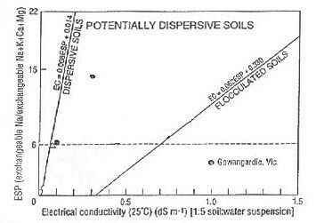 Prediction of dispersive potential for soils affected by tunnel erosion near Gowangardie (after Fitzpatrick et al. 1994). | 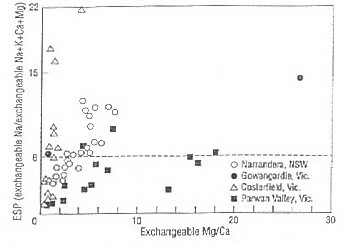 The relation between ESP and Exchangeable Mg/Ca for soils affected by tunnel erosion near Gowangardie (after Fitzpatrick et al. 1994). |
Downes (1949) also reported that gullies formed in soils that had a high level of aggregate stability. In both the Dookie and Cashel soil series which are located north of Broken River, 'V'-shaped gullies had incised subsoils in which soil sodicity was far less important in causing erosion than at the other two sites.
Some Characteristics of a Soil Profile from Dookie (Downes 1946, 1949).
Horizon | Horizon Depth (") | Horizon Depth (cm)a | Texture | pH (Water) 1:5 | Sum of Major Cations | ESPb |
A1 | 0-8 | 0-20 | Friable clay loam | 6.6 | 9.7 | 2 |
B1 | 8-14 | 20-36 | Friable clay | 6.7 | 8.5 | 1 |
B21 B22 | 14-25 25-50 | 36-64 64-127 | Friable clay Friable clay | 6.4 7.4 | na 23.0 | na 2 |
BC | 50-72 | 127-183 | Friable clay | 8.7 | na | na |
| Legend a inserted by the author. b calculated as ESP [m.e. 100g] = Exchangeable Na [100] Sum of Major Exchangeable Cations na not available. | ||||||
M. Imhof (pers. comm.) classified the above profile as a Red Ferrosol (Isbell, 1996).
Some Characteristics of a Soil Profile from Cashel (Downes 1946 1949).
Horizon | Horizon Depth (") | Horizon Depth (cm)a | Texture | pH (Water) 1:5 | Sum of Major Cations | ESPb |
A1 | 0-8 | 0-20 | Friable clay loam | 6.6 | 9.7 | 2 |
B1 | 8-14 | 20-36 | Friable clay | 6.7 | 8.5 | 1 |
B21 B22 | 14-25 25-50 | 36-64 64-127 | Friable clay Friable clay | 6.4 7.4 | na 23.0 | na 2 |
BC | 50-72 | 127-183 | Friable clay | 8.7 | na | na |
| Legend a inserted by the author. b calculated as ESP [m.e. 100g] = Exchangeable Na [100] Sum of Major Exchangeable Cations na not available. | ||||||
M. Imhof (pers. comm.) classified the above profile as a Black Dermosol (Isbell, 1996).
Early attempts at reclaiming tunnel-eroded land in this district were focussed on the destruction of tunnels and subsequent contour furrowing. The aim of this approach was to reduce localised points of preferential infiltration and, as at 1946, the techniques had been successful. The problems associated with this type of mechanical reclamation were reviewed in detail by Boucher (1990). Downes also recommended the sowing of a low-fertility pasture such as rye which was to be allowed to re-seed and rot to provide a protective land surface cover. This mulch was intended to offer protection from raindrop impact and confer beneficial effects to the soil in terms of fertility, structure and organic matter.
References
Boucher SC (2003a) Tunnel erosion.
Boucher SC (2003b) Gully erosion.
Downes RG (1946) Tunnelling erosion in north-eastern Victoria. Journal of the Council for Scientific and Industrial Research 19, 283-292. [note: this Journal was the forerunner of the Australian Journal of Soil Research] (external link)
Downes RG (1949) A soil, land-use, and erosion survey of parts of the Counties of Moira and Delatite, Victoria. CSIRO Australia, Bulletin No. 243. To view the information PDF requires the use of a PDF reader.
Downes RG (1958) Land management problems following disturbance of the hydrologic balance of environments in Victoria, Australia. In ‘Proceedings of the International Union for Conservation of Nature and Natural Resources’, seventh technical meeting. (11 - 19 September 1958, Athens) (Reprint). (Government Printer: Melbourne) 19 pp.
Downes RG (1974) Land, land use and soil conservation. In ‘Conservation’. (Revised Edition). (Eds AB Costin, HJ Frith) pp. 49-76. (Penguin Books: Harmondsworth)
Downes RG, Leeper GW (1940) The measurement of soil structure. Proceedings of the Royal Society of Victoria 52, 1-20.
Fitzpatrick RW, Boucher SC, Naidu R, Fritsch E (1994) Environmental consequences of soil sodicity. Australian Journal of Soil Research 32, 1069-1093.
Ford GW, Martin JJ, Rengasamy P, Boucher SC, Ellington A (1993) Soil sodicity in Victoria. Australian Journal of Soil Research 31, 869-909.
Isbell RF (1996) ‘The Australian soil classification’. (CSIRO Australia: Collingwood)
Rengasamy P, Greene RSB, Ford GW, Mehanni AH (1984) Identification of dispersive behaviour and the management of Red-brown Earths. Australian Journal of Soil Research 22, 413-431.

© The State of Victoria, 1996 - 2025.
This page was last updated on 23/03/2020.