
Gully Initiation and Development
Gully Erosion Home | Distribution of Gully Erosion | Gully Reclamation Techniques | Conclusions | References
Antecedent Conditions: an Introduction
Prosser et al. (1994) found evidence of gully erosion in southeastern New South Wales (NSW) during the Holocene (i.e. 10-0 ka BP: Williams et al. 1993) and contrasted these findings with episodes resulting from European settlement (e.g. Prosser 1991; 1996). A 'chain of ponds' was frequently observed in NSW and Victoria by early explorers and settlers (Eyles 1977a) and these were often the precursors of gully erosion (Eyles 1977b). As was described in greater detail for tunnel erosion, it has been suggested that gullying was also probably well-developed in soft alluvial sediments and the sodic duplex soils of the cleared uplands in southeastern Australia by the 1840s and 1850s (Jenkin 1986). An early reference to gully erosion in Victoria was made by Robertson in 1853 (see Land degradation in Victoria), with the incision made by ''uts' (i.e. equivalent to the term 'gullies' used in this entry) being 7' (2.8 m) to 10' (3.9 m) deep and wide. Strom (1940, 107) reported that the word 'gullies', when used in Australia, also referred to '... small steep-sided natural valleys ...' and it is apparent that this was the definition employed by Robertson.
Gully Initiation and Development
Tunnel erosion is frequently grouped with gullying (e.g. Davis et al., 1999) but the processes, mechanisms, and resulting landforms involved are often quite distinct (e.g. Milton, 1971). Gullies have been classified according to various criteria (e.g. Bocco, 1991; Bull and Kirkby, 1997). Ireland et al. (1939) described six main gully head types according to plan view in South Carolina (USA), these being 'bulbous', 'compound', 'dendritic', 'linear', 'parallel' and 'trellis' (Rosewell et al., 1991). The scheme of Brice (1966), which focussed on the topographic location of gullies and included 'valley-head', 'valley-bottom' and 'valley-side' examples in Nebraska (USA), was reviewed in detail by Higgins et al. (1990). Heede (1970) classified gullies as 'continuous' and 'discontinuous' in Colorado (USA). The cross-sectional shape of gullies has also been used as an indicator of type, and inferences have been drawn as to the mechanisms operating, such as was the case in Morocco (e.g. Imeson et al., 1982). Gully sidewalls were examined in further detail in NSW by Blong et al. (1982), Blong (1985) and Crouch and Blong (1989).
A considerable amount of research into gully erosion has been conducted in NSW over the past two decades (e.g. Veness, 1980; Gillespie, 1981; Crouch, 1983; 1987; 1990; Graham, 1984; Sneddon et al., 1988; Starr, 1989; Prosser, 1991; Prosser and Slade, 1994; Prosser and Winchester, 1996; Prosser and Soufi, 1998; Wasson et al., 1998; Croke and Mockler, 2001), but little has been published in terms of the mechanisms operating in Victoria apart the work of Milton (1971), Rutherfurd and Smith (1992), Boucher and Powell (1994) and Davis et al. (1999). The mechanisms described by Milton (1971) are only discussed briefly here as his report has been reproduced in full, by permission.
Gullies have often been initiated when water concentrated in a small surface depression, such as caused naturally on the land surface or as a result of livestock tracks, furrows and ruts left by farm machinery (e.g. Bennett, 1939). When a series of depressions was sufficiently enlarged by subsequent flow so that they merged, an incipient channel remained (Morgan, 1986). Prosser (1991, Figure 1) noted that causes of gully erosion included fire, drought, floods, reduced infiltration, steepening of slopes and confined flow as well as changes in climate, fire frequency, landuse and vegetation. The work of humans in terms of construction, ploughing and the establishment of drains and roads was also mentioned. With regard to the latter set of factors, a recent study in southeastern Australia outlined the linkages between gully initiation and roadworks in a forested catchment (Croke and Mockler, 2001). In a recent review of gully erosion in eastern Australia, Prosser and Winchester (1996), noted that few studies have included a quantification of the forces involved when flows overcame a threshold resistance of material to scour, causing channel initiation.
The following examples of development of gully head erosion were published by Milton (1971), with further details provided in that document. There is a lack of detailed information regarding the processes of gully development in Victoria.
Erosion by Waterfalls
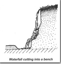 | 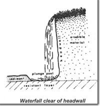 |
| Headward Erosion by Water Fall This is historic footage of gully headward erosion by water fall - near Darraweit Guim - 40 years ago. Photographed by Lindsay Milton. This silent video clip runs for 1 minute and 29 seconds and is 3.0MB in size, this will take some time to automatically download if you are using a slow internet connection. Click the 'play' button and the video should display directly in your browser if this does not happen you need to update the 'Adobe Flash Player'. This software can be downloaded for free from the Adobe website (external link). |
We have detected that the browser used to view this content is missing the supported 'Flash plugin'. Once you have installed the 'plugin' found on the Adobe website, please return to this web page by using the back button on your browser. |
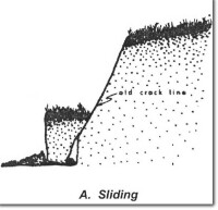
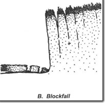
Mechanisms of Erosion by Gravity Collapse
 |  |
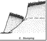 | 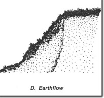 |
| Varieties of Extrusion Sapping | |
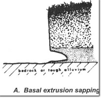 | 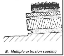 |
 | |
| Gully Headward Erosion by A horizon Extrusion Sapping This is historic footage of gully headward erosion by A horizon extrusion sapping - near Darraweit Guim - 40 years ago, taken by Lindsay Milton who was the one who recognised the range of mechanisms causing the headward erosion of gullies. This silent video clip runs for 31 seconds and is 1MB in size, this will take some time to automatically download if you are using a slow internet connection. Click the 'play' button and the video should display directly in your browser if this does not happen you need to update the 'Adobe Flash Player'. This software can be downloaded for free from the Adobe website (external link). | We have detected that the browser used to view this content is missing the supported 'Flash plugin'. Once you have installed the 'plugin' found on the Adobe website, please return to this web page by using the back button on your browser. |
McDonald et al. (1990) proposed a maximum gully depth rating which comprised three classes; exceeding 0.3 m but less than 1.5 m, between 1.5 m and 3.0 m, and greater than 3.0 m. Working in the Avoca River catchment in northwestern Victoria, Rutherfurd and Smith (1992) estimated that there were aproximately 150 km of true gullies and more than 200 km of widened and deepened streams. They cited Glenlogie Gully as an example of a recent gully system and noted that it was up to 10.3 m wide, 5 m deep and approximately 3 km in length.
Critical Soil Properties which affect Gully Erosion in Victoria
Gullies have formed in various soil types in Victoria and Downes (1946; 1949) related the cross-sectional shape of a gully to differences in particular soil characteristics between horizons in northeastern Victoria. For example, he found that a 'U'-shaped cross-section was associated with dispersive subsoils (see following diagram).
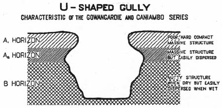
© CSIRO Reproduced with permission of CSIRO PUBLISHING.
http://www.publish.csiro.au/journals/ajsr/ (external link)
One set of soil profile data for Caniambo was discussed in the entry on tunnel erosion, whilst data from Gowangardie are presented in the following table. It is clear from the ESP that the subsoils were strongly sodic, as was the case at Caniambo.
Profile Characteristics | Horizon | Horizon Depth (") | Horizon Depth (cm)a | Texture | pH 1:5 | Sum of Major Cations | ESPb |
Iron-impregnated chips; | A1 | 0-2 | 0-5 | Loam | 5.6 | 6.9 | 6.3 |
Iron-impregnated chips; | A2 | 2-5 | 5-13 | Loam to sandy loam | 5.6 | na | na |
Small, nutty when dry & plastic and sticky when wet | B1 B1 | 6-15 15-27 | 15-38 38-69 | Clay Clay | 6.0 6.1 | 10.2 na | 14.3 na |
Ordovician & Silurian slates, sandstones, shales & quartzites | BC | na | na | Clay | na | na | na |
Legend
a inserted by the author and M. Imhof (pers. comm.)
b calculated as ESP [m.e. 100 g] = Exchangeable Na [100]
na not available.
M. Imhof (pers. comm.) classified the above profile as Solodised Solonetz and Solodic (Stace et al., 1968), Db/Dr 2.41 (Northcote, 1979) and Red/Brown Sodosol (Isbell, 1996).
On the other hand, gullies have also formed in soils which have a high level of aggregate stability. In both the Dookie and Cashel soil series of northeastern Victoria (Downes 1946; 1949), 'V'-shaped gullies had incised subsoils in which soil sodicity was far less important in causing erosion than at the other two sites.
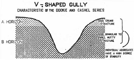
© CSIRO Reproduced with permission of CSIRO PUBLISHING.
http://www.publish.csiro.au/journals/ajsr/
Horizon | Horizon Depth (") | Horizon Depth (cm)a | Texture | pH 1:5 | Sum of Major Cations | ESPb |
A1 | 0-8 | 0-20 | Friable clay loam | 6.6 | 9.7 | 1.8 |
B1 | 8-14 | 20-36 | Friable clay | 6.7 | 8.5 | 1.2 |
B21 B22 | 14-25 25-50 | 36-64 64-127 | Friable clay Friable clay | 6.4 7.4 | na 23.0 | na 1.8 |
BC | 50-72 | 127-183 | Friable clay | 8.7 | na | na |
Legend
b calculated as ESP [m.e. 100 g] = Exchangeable Na [100]
na not available.
M. Imhof (pers. comm.) classified the above profile as No Suitable Group (Stace et al., 1968), Gn 3.13 (Northcote, 1979) and Red Ferrosol (Isbell, 1996).
Horizon | Horizon Depth (") | Horizon Depth (cm)a | Texture | pH 1:5 | Sum of Major Cations | ESPb |
A1 | 0-4 | 0-10 | Friable clay loam | 8.3 | 48.8 | 1.2 |
B21 | 4-16 | 10-41 | Friable clay | 8.7 | 57.6 | 0.9 |
B22 B23 | 16-30 30-50 | 41-76 76-127 | Friable clay Friable clay | 8.9 8.9 | 63.6 55.8 | 1.4 5.0 |
BC | 50-63 | 127-160 | Friable clay | 8.8 | 53.4 | 6.6 |
Legend
a inserted by the author.
b calculated as ESP [m.e. 100 g] = Exchangeable Na [100]
na not available.
M. Imhof (pers. comm.) classified the above profile as Black Earth (Stace et al., 1968), Gn 3.43 (Northcote, 1979) and Black Dermosol (Isbell, 1996).
© State of Victoria (Agriculture Victoria) 1996 - 2025.

This work, Victorian Resources Online, is licensed under a Creative Commons Attribution 4.0 licence. You are free to re-use the work under that licence, on the condition that you credit the State of Victoria (Agriculture Victoria) as author, indicate if changes were made and comply with the other licence terms.
The licence does not apply to ‘branding’ or some ‘images or photographs’ that may be owned by third parties. We ask you to seek prior approval to use images using the VRO feedback form. Access to higher quality images can also be provided on request.
This page was last updated on 22/02/2021.