
Soil/Landform Unit - Belellen undulating rises
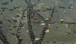
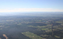 Looking north-east towards Stawell across the Belellen plains and rises |
0.59% of CMA region Undulating rises that occur within the Concongella Creek and Mount William Creek catchments are composed of Neogene fluvial gravel, sand and silt deposits that overlie Palaeozoic bedrock. The Bellellen undulating rises unit has been differentiated on landform and regolith into undulating low hills and rises (Bellellen 3) from footslopes and foothills (Bellellen 1 and 2). The hillslopes and crests of the low hills and rises are characterised by regolith profiles with shallow degrees of weathering and little Neogene fluvial remnants. Soils tend to be red to yellow texture contrast soils (Chromosols) that may be sodic and brown (Sodosols) lower in the landscape. Footslopes and gentle rises comprise simple slopes, broad crests and drainage depressions with extensive weathering profiles dominated by kaolinite, or by ferruginised sand where Neogene sediments were deposited masking subsurface bedrock. Soils here tend to be sodic and non-sodic but with higher concentrations of yellow and brown texture contrast soils with minor red equivalents. Land use has traditionally been grazing but dryland cropping is increasing in intensity across these rises. Native vegetation communities of Plains Grassy Woodland and Box Ironbark Forest are dominant, with less expansive vegetation including woodlands, forest, marsh and wetland. | 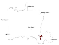 |
 Bellellen undulating rises | 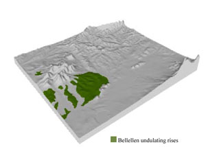 |
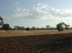
|  Dispersive subsoils observed in dam water colour |
Component | 1 | 2 | 3 | 4 | 5 | 6 |
Proportion of soil-landform unit | 10% | 25% | 10% | 25% | 20% | 10% |
| CLIMATE Rainfall (mm) | Annual: 580 | |||||
| Temperature (oC) | Minimum 8, Maximum 20 | |||||
| Precipitation less than potential evapotranspiration | October–April | |||||
| GEOLOGY Age and lithology | Neogene fluvial gravel, sand and silt; Cambrian basalt, andesite, boninite, rhyolite, gabbro and lithics; Cambrian marine sandstone, siltstone and shale (Glenthompson Sandstone) | |||||
| Geomorphology | ||||||
| LANDUSE | Uncleared areas: nature conservation; recreational activities; water supply Cleared areas: sheep grazing; dryland cropping; residential development; water supply | |||||
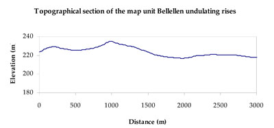
| TOPOGRAPHY Landscape | Undulating rises | |||||
| Elevation range (m) | 180–301 | |||||
| Local relief (m) | 20 | |||||
| Drainage pattern | Dendritic | |||||
| Drainage density (km/km2) | 1.2 | |||||
| Landform | Undulating low hills and rises (Bellellen 3) | Footslopes and foothills (Bellellen 1 and 2) | ||||
| Landform element | Hillcrest and upper slope | Mid slope | Lower colluvial slope and drainage line | Simple slope | Broad low crest | Drainage line |
| Slope and range (%) | 6 (2-32) | 5 (2-15) | 3(0-10) | 3 (1-15) | 1 (0-3) | 3 (1-15) |
| Slope shape | Convex | Concave | Concave | Convex | Straight | Concave |
| NATIVE VEGETATION Ecological Vegetation Class | Plains Grassy Woodland (45.8%), Box Ironbark Forest (24.8%), Heathy Woodland (15.2%), Other (12.9%) | |||||
| SOIL Parent material | In situ sandstone, siltstone and shale | In situ sandstone, siltstone and shale | In situ sandstone, siltstone and shale | Neogene fluvial gravel, sand and silt | Neogene fluvial gravel, sand and silt | Fluvial gravel, sand and silt |
| Description (Corangamite Soil Group) | Sodic and non-sodic, yellow and brown texture contrast soils (5) | |||||
| Soil type sites | ||||||
| Surface texture | Fine sandy loam to silty loam | Sandy clay loam | Sandy clay loam | Sandy clay loam | Silty loam | Sandy clay loam |
| Permeability | Moderate to high | Moderate | Moderate | Moderate | High | Moderate |
| Depth (m) | 0.7 | 1.2 | 2 | 2 | 1 | > 2 |
| LAND CHARACTERISTICS, POTENTIAL AND LIMITATIONS Critical land features, processes, forms | Gradational gravelly soils are well drained. Friable with better infiltration in moister areas, hardsetting surfaces are more prone to sheet and rill erosion in drier areas (north and westerly aspects). Susceptible to acidification in wetter areas. | Texture contrast soils with subsurface soil and upper subsoil susceptible to compaction. Gully erosion occurs where sodic subsoils are exposed. Topsoil may be susceptible to acidification. | Texture contrast soils with hardsetting surfaces. Subsurface soil and upper subsoil susceptible to compaction. Gully erosion occurs where sodic subsoils exposed, dispersive subsoil evident in farm dams. Topsoil may be susceptible to acidification. | Texture contrast soils with hardsetting surfaces. Subsurface soil and upper subsoil susceptible to compaction. Gully erosion occurs where sodic subsoils exposed, dispersive subsoil evident in farm dams. Topsoil may be susceptible to acidification. | Gradational gravelly soils are well drained on rise crests. Topsoil susceptible to increased acidification. | Texture contrast soils with hardsetting surfaces. Subsurface soil and upper subsoil susceptible to compaction. Gully erosion occurs where sodic subsoils exposed, dispersive subsoil evident in farm dams. Topsoil may be susceptible to acidification. |
© State of Victoria (Agriculture Victoria) 1996 - .

This work, Victorian Resources Online, is licensed under a Creative Commons Attribution 4.0 licence. You are free to re-use the work under that licence, on the condition that you credit the State of Victoria (Agriculture Victoria) as author, indicate if changes were made and comply with the other licence terms.
The licence does not apply to ‘branding’ or some ‘images or photographs’ that may be owned by third parties. We ask you to seek prior approval to use images using the VRO feedback form. Access to higher quality images can also be provided on request.
This page was last updated on .