
Soil/Landform Unit - Mokepilly undulating plains
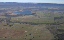 Level to gentle plains north of Lake Evans |
0.14% of CMA region This unit of low-lying terrain of undulating plains consists of two main occurrences. These plains and associated rolling terrain are part of Dissected Western Uplands as part of the residual Cainozoic landscapes (2.1.5). These near-level plains lie between the Grampians Ranges and eastern Black Ranges, north of Lake Fyans. The plains and flats are dominant with dunes, rises and drainage depressions as minor landscape components. The plains receive surface drainage from the surrounding upland rises and hills. Yellow and brown sodic texture contrast soils with sandy topsoils of varying depth are common (Sodosols) with sandy soils on dunes (Tensosols) and minor brown and red sodic texture contrast soils (Sodosols). Sheet and rill erosion, as well as compaction, are potential land degradation susceptibilities with a minor susceptibility to wind erosion and waterlogging depending on landform (dune or depression). Remnant native vegetation communities such as Damp Sands Herb-rich Woodland, Heathy Woodland, Plains Grassy Woodland, Red Gum Wetland and Lateritic Woodland have been recorded. |  |
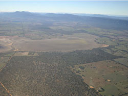 Level plains south of Lake Londsale bordering Mount William Creek | 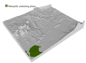 |
 | 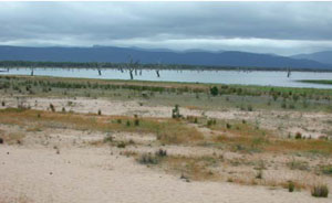 Lake Fyans |
Component | 1 | 2 | 3 | 4 |
Proportion of soil-landform unit | 15% | 70% | 5% | 10% |
| CLIMATE Rainfall (mm) | Annual: 640 | |||
| Temperature (oC) | Minimum 8, Maximum 20 | |||
| Precipitation less than potential evapotranspiration | October–March | |||
| GEOLOGY Age and lithology | Quaternary fluvial gravel, sand and silt; Cambrian ‘greenstone’ - basalt, andesite, boninite, rhyolite, gabbro, lithic sandstone, chert, shale and breccia | |||
| Geomorphology | ||||
| LANDUSE | Uncleared areas: water supply; nature conservation; sand extraction Cleared areas: sheep and beef cattle grazing; dryland cropping; sand extraction; water supply | |||
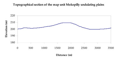
| TOPOGRAPHY Landscape | Undulating plains | |||
| Elevation range (m) | 186–215 | |||
| Local relief (m) | 5 | |||
| Drainage pattern | Dendritic | |||
| Drainage density (km/km2) | 0.7 | |||
| Landform | Low dunes | Alluvial plains | ||
| Landform element | Dune | Plain | Drainage depression | Low rise slope |
| Slope and range (%) | 3 (1-7) | 1 (0-3) | 1 (0-2) | 2 (1-6) |
| Slope shape | Convex | Straight | Concave | Convex |
| NATIVE VEGETATION Ecological Vegetation Class | Plains Grassy Woodland (65.8%), Red Gum Wetland (11.6%), Plains Woodland/Plains Sedgy Woodland/Damp Sands Herb-rich Woodland (10.8%), Other (11.9%) | |||
| SOIL Parent material | Aeolian dune sand | Fluvial gravel, sand and silt | Fluvial gravel, sand and silt | Fluvial gravel, sand and silt, minor greenstone |
| Description (Corangamite Soil Group) | Shallow and sandy weakly developed soils (13) | Sodic and non-sodic, yellow and brown texture contrast soils (5) | Sodic and non-sodic, yellow and brown texture contrast soils (5) | Sodic and non-sodic, brown and red texture contrast soils (6) |
| Soil type sites | ||||
| Surface texture | Loamy sand | Sandy clay loam | Sandy clay loam | Sandy loam (silty) |
| Permeability | High | Moderate - slow | Slow | Moderate |
| Depth (m) | 0.5 | > 2 | > 2 | < 2 |
| LAND CHARACTERISTICS, POTENTIAL AND LIMITATIONS Critical land features, processes, forms | Light sandy soils with weakly coherent surfaces that are subject to severe wind erosion where exposed. Acidic soils with low inherent fertility. Rapid drainage and high soil permeability. | Hardsetting surfaces susceptible to sheet and rill erosion even on gentle slope due to impeding layer (clay or hardpan). Subsurface soil and upper subsoil susceptible to compaction. Extremely prone to gully erosion where sodic subsoils are exposed and vulnerable. Topsoil may be susceptible to acidification. | Subsurface soil and upper subsoil susceptible to compaction. Extremely prone to gully erosion where sodic subsoils are exposed and vulnerable. Topsoil may be susceptible to acidification. | Hardsetting and soft surfaces susceptible to sheet and rill erosion even on gentle slope due to impeding layer (clay or hardpan). Subsurface soil and upper subsoil susceptible to compaction, and also gully erosion where sodic and deep. Topsoil may be susceptible to acidification. |
© State of Victoria (Agriculture Victoria) 1996 - 2025.

This work, Victorian Resources Online, is licensed under a Creative Commons Attribution 4.0 licence. You are free to re-use the work under that licence, on the condition that you credit the State of Victoria (Agriculture Victoria) as author, indicate if changes were made and comply with the other licence terms.
The licence does not apply to ‘branding’ or some ‘images or photographs’ that may be owned by third parties. We ask you to seek prior approval to use images using the VRO feedback form. Access to higher quality images can also be provided on request.
This page was last updated on 25/01/2019.