
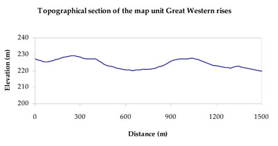
Soil/Landform Unit - Great Western rises
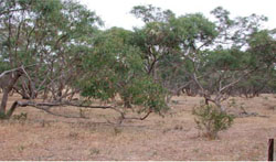
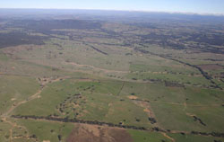 View south-west towards the Ararat Hills across Armstrong and the Great Western rises. Note the prominent gullying within this landscape |
1.76% of CMA region Across the upper Wimmera River catchment exists a number of fringing sheets of capping material across underlying Palaeozoic bedrock. These undulating rises include preservation of this underlying bedrock as ferricrete and silcrete. As well as lining valley floors, these rises are discontinuous due to a series of drainage networks that have dissected these deposits. Locally relief tends to be less than 30 metres with slopes gentle to undulating. Soils are also variable with yellow to brown, sodic and non-sodic equivalent texture contrast soils (Sodosols and Chromosols) common. The rises represent local groundwater systems that are very slowly permeable with significant salt stores. Salinity discharge, scald erosion, gully and tunnel erosion are major land degradation issues. Land use is mainly grazing owing to poor soil water holding capacity of these soils, however cereal cropping has become more widespread recently. The main vegetation communities include Heathy Dry Forest, Grassy Dry Forest, Heathy Woodland, Plains Grassy Woodland, Alluvial Terraces Herb-rich Woodland, Grassy Woodland, Plains Woodland and Creekline Grassy Woodland. | 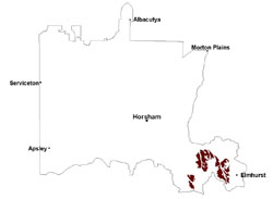 |
 Undulating rises of the Salt Creek catchment | 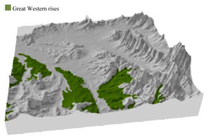 |
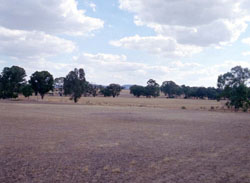
 |  Grey box brown stringybark on Tertiary |
Component | 1 | 2 | 3 | 4 | 5 | 6 |
Proportion of soil-landform unit | 18% | 7% | 25% | 12% | 30% | 8% |
| CLIMATE Rainfall (mm) | Annual: 590 | |||||
| Temperature (oC) | Minimum 8, Maximum 19 | |||||
| Precipitation less than potential evapotranspiration | October–March | |||||
| GEOLOGY Age and lithology | Cambrian marine sandstone, siltstone and biotite schist (St Arnaud Group); Neogene fluvial gravel, sand and silt; Quaternary fluvial gravel, sand and silt | |||||
| Geomorphology | ||||||
| LANDUSE | Uncleared areas: water supply; nature conservation; gravel extraction Cleared areas: dryland cropping; sheep and beef cattle grazing; residential development | |||||
| TOPOGRAPHY Landscape | Foothills and footslopes | |||||
| Elevation range (m) | 189–427 | |||||
| Local relief (m) | 10–40 | |||||
| Drainage pattern | Dendritic | |||||
| Drainage density (km/km2) | 1.3 | |||||
| Landform | Rise–footslopes (Great Western 2) | Foothills–low hills (Great Western 3) | ||||
| Landform element | Rise slope | Drainage depression | Plain | Hillslope | Footslope | Plain and drainage line |
| Slope and range (%) | 5 (3-10) | 2 (0-5) | 3 (1-8) | 15 (10-32) | 5 (3-10) | 2 (1--5) |
| Slope shape | Convex | Convex | Concave | Convex | Concave | Concave |
| NATIVE VEGETATION Ecological Vegetation Class | Grassy Woodland (42.2%), Heathy Woodland (20.5%), Alluvial Terraces Herb-rich Woodland (14.4%), Other (20.4%) | |||||
| SOIL Parent material | In situ sandstone, siltstone and biotite schist, minor granite | Fluvial gravel, sand and silt | Fluvial gravel, sand and silt, minor colluvial deposits | In situ sandstone, siltstone and biotite schist, granite | Colluvial and alluvial gravel sand and silt, | Fluvial gravel, sand and silt |
| Description (Corangamite Soil Group) | Sodic and non-sodic, yellow and brown texture contrast soils (5) | Sodic and non-sodic, yellow and brown texture contrast soils (5) and sodic and non-sodic, brown and red texture contrast soils (6) | Sodic and non-sodic, yellow and brown texture contrast soils (5) | |||
| Soil type sites | ||||||
| Surface texture | Sandy loam | Sandy clay loam | Sandy loam | Sandy loam | Sandy loam | Sandy clay loam |
| Permeability | Moderate | Moderate | Moderate | Moderate | Moderate | Moderate |
| Depth (m) | 2 | > 2 | 2 | 0.7 | 2 | > 2 |
| LAND CHARACTERISTICS, POTENTIAL AND LIMITATIONS Critical land features, processes, forms | Hardsetting and soft surfaces susceptible to sheet and rill erosion even on gentle slope due to impeding layer (clay or hardpan). Subsurface soil and upper subsoil susceptible to compaction, and also gully erosion where sodic and deep. Topsoil may be susceptible to acidification. | Hardsetting and soft surfaces susceptible to sheet and rill erosion even on gentle slope due to impeding layer (clay or hardpan). Subsurface soil and upper subsoil susceptible to compaction, and also gully erosion where sodic and deep. Topsoil may be susceptible to acidification. | Hardsetting and soft surfaces susceptible to sheet and rill erosion even on gentle slope due to impeding layer (clay or hardpan). Subsurface soil and upper subsoil susceptible to compaction, and also gully erosion where sodic and deep. Topsoil may be susceptible to acidification. | Friable with better infiltration in moister areas, hardsetting and more prone to sheet and rill erosion in drier areas (north and westerly aspects). Susceptible to acidification in wetter areas. Sodic subsoil prone to gully and tunnel erosion. | Hardsetting and soft surfaces susceptible to sheet and rill erosion even on gentle slope due to impeding layer (clay or hardpan). Subsurface soil and upper subsoil susceptible to compaction, and also gully erosion where sodic and deep. Topsoil may be susceptible to acidification. | Hardsetting and soft surfaces susceptible to sheet and rill erosion even on gentle slope due to impeding layer (clay or hardpan). Subsurface soil and upper subsoil susceptible to compaction, and also gully erosion where sodic and deep. Topsoil may be susceptible to acidification. |
© State of Victoria (Agriculture Victoria) 1996 - .

This work, Victorian Resources Online, is licensed under a Creative Commons Attribution 4.0 licence. You are free to re-use the work under that licence, on the condition that you credit the State of Victoria (Agriculture Victoria) as author, indicate if changes were made and comply with the other licence terms.
The licence does not apply to ‘branding’ or some ‘images or photographs’ that may be owned by third parties. We ask you to seek prior approval to use images using the VRO feedback form. Access to higher quality images can also be provided on request.
This page was last updated on .