
Soil/Landform Unit - Glenorchy rises
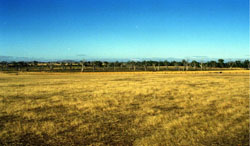
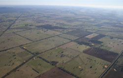 Glenorchy rises looking north-west towards Dadswells Bridge with the Wimmera River in the north |
1.06% of CMA region Gentle rises south-east of Glenorchy constitute part of the Cainozoic landscapes of the Dissected Western Uplands (2.1.5). Derived mainly of Parilla Sand, the rises are divided into landforms with parent material sourced from in situ Parilla Sand with the more prominent rises having deeply weathered regolith profiles that include significant kaolinitic development under Cainozoic deposits. Plains, rises and drainage depressions are the major landform components with soils including sodic and non-sodic, red, yellow and brown texture contrast soils (Chromosols and Sodosols) and red gradational or uniform soils (Dermosols) dominant. Hardsetting and soft surfaces are susceptible to sheet and rill erosion even on gentle slopes due to impeding layers such as hardpans or massive clay subsoils. Gully erosion occurs where sodic subsoils are exposed while topsoils may be susceptible to acidification. Dryland cereal cropping along with sheep grazing are major land uses. Vegetation communities range from Heathy Woodland to Box Ironbark Forest and Plains Sedgy Woodland. | 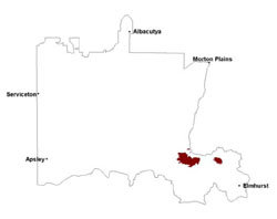 |
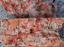 Stiking mottling found within subsoils of the sedimentary rises | 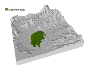 |
 |  Greens Swamps at Greens Creek |
Component | 1 | 2 | 3 | 4 |
Proportion of soil-landform unit | 3% | 55% | 32% | 10% |
| CLIMATE Rainfall (mm) | Annual: 540 | |||
| Temperature (oC) | Minimum 8, Maximum 20 | |||
| Precipitation less than potential evapotranspiration | October–April | |||
| GEOLOGY Age and lithology | Quaternary fluvial silt, sand, minor gravel (Shepparton Formation); Neogene fluvial silt, sand, minor gravel; Cambrian marine sandstone, siltstone, biotite schist (St Arnaud Group); Cambrian ‘greenstone’ – basalt, andesite, boninite, rhyolite, gabbro, lithic sandstone, chert, shale and breccia | |||
| Geomorphology | ||||
| LANDUSE | Uncleared areas: water supply; nature conservation Cleared areas: heep and beef cattle grazing; dryland cropping; water supply | |||
| TOPOGRAPHY Landscape | Dissected plain | |||
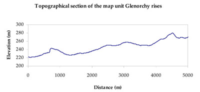
| Elevation range (m) | 159–282 | |||
| Local relief (m) | 20 | |||
| Drainage pattern | Dendritic | |||
| Drainage density (km/km2) | 0.6 | |||
| Landform | Rises (Glenorchy 2) | Plains (Glenorchy 1) | ||
| Landform element | Drainage depression | Rise | Plain | Drainage depression |
| Slope and range (%) | 3 (1-7) | 5 (3-10) | 2 (1-5) | 1 (0-2) |
| Slope shape | Concave | Convex | Straight | Concave |
| NATIVE VEGETATION Ecological Vegetation Class | Plains Grassy Woodland (37.1%), Plains Woodland (19.6%), Heathy Woodland (13.2%), Grassy Woodland (6.6%), Other (22.1%) | |||
| SOIL Parent material | Alluvial sand, silt and minor gravel | Marine sandstone, siltstone and biotite schist, minor greenstone | Marine and fluvial silt, sand and gravel | Alluvial gravel, sand and silt |
| Description (Corangamite Soil Group) | Sodic and non-sodic, yellow and brown texture contrast soils (5) | Sodic and non-sodic, brown and red texture contrast soils (6) red gradational or uniform soils (7) | Sodic and non-sodic, yellow and brown texture contrast soils (5) and sodic and non-sodic, brown and red texture contrast soils (6) | Sodic and non-sodic, yellow and brown texture contrast soils (5) |
| Soil type sites | ||||
| Surface texture | Sandy clay loam | Silty loam | Sandy clay loam | Sandy clay loam |
| Permeability | Moderate | Moderate to high | Moderate | Moderate |
| Depth (m) | > 2 | 1.5 | 2 | > 2 |
| LAND CHARACTERISTICS, POTENTIAL AND LIMITATIONS Critical land features, processes, forms | Hardsetting and soft surfaces susceptible to sheet and rill erosion even on gentle slopes due to impeding layer (clay or hardpan). Subsurface soil and upper subsoil susceptible to compaction, and also gully erosion where sodic and deep. Topsoil may be susceptible to acidification. | Gradational gravelly soils are well drained, steeper slopes with hardsetting and soft surfaces are susceptible to sheet and rill erosion (especially lighter surface soil). Upper soil susceptible to increased acidification | Hardsetting and soft surfaces susceptible to sheet and rill erosion even on gentle slope due to impeding layer (clay or hardpan). Subsurface soil and upper subsoil susceptible to compaction. Gully erosion occurs where sodic subsoils are exposed. Topsoil may be susceptible to acidification. | Hardsetting and soft surfaces susceptible to sheet and rill erosion even on gentle slope due to impeding layer (clay or hardpan). Subsurface soil and upper subsoil susceptible to compaction, and also gully erosion where sodic and deep. Topsoil may be susceptible to acidification. |
© State of Victoria (Agriculture Victoria) 1996 - .

This work, Victorian Resources Online, is licensed under a Creative Commons Attribution 4.0 licence. You are free to re-use the work under that licence, on the condition that you credit the State of Victoria (Agriculture Victoria) as author, indicate if changes were made and comply with the other licence terms.
The licence does not apply to ‘branding’ or some ‘images or photographs’ that may be owned by third parties. We ask you to seek prior approval to use images using the VRO feedback form. Access to higher quality images can also be provided on request.
This page was last updated on .