
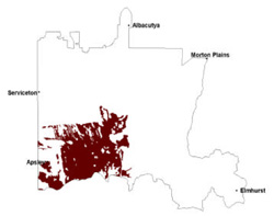
38. Sodic brown, yellow and grey texture contrast soils/Ridges with sand and flats: Low remnant ridge tops with aeolian sands and oriented swales
|
These soils have developed on Quaternary unconsolidated material, generally of riverine, aeolian and lacustrine origin in the North West Dunefields and Plains, south of the Little Desert. The soil has a slightly acidic surface with a slightly acidic to slightly alkaline upper subsoil becoming strongly alkaline below. Variations may be influenced by climate variation.
|  |
Soil Sites
Site code | Soil-landform unit | Component | ASC | FK | 1:100 000 mapsheet |
| LSWW11 | Kybybolite plains | Hillslope | Hypercalcic, Mottled-Hypernatric, Brown Sodosol | Db4.43 | T7124 - Goroke |
| LSWW17 | Kowree undulating sand plains and ridges | Riseslope | Calcic, Mottled-Mesonatric, Yellow Sodosol | Dy5.43 | T7123 - Edenhope |
| LSWW13 | Ullswater plains and rises | Riseslope | Calcic, Mottled-Mesonatric, Grey Sodosol | Dg4.43 | T7124 - Goroke |
© State of Victoria (Agriculture Victoria) 1996 - .

This work, Victorian Resources Online, is licensed under a Creative Commons Attribution 4.0 licence. You are free to re-use the work under that licence, on the condition that you credit the State of Victoria (Agriculture Victoria) as author, indicate if changes were made and comply with the other licence terms.
The licence does not apply to ‘branding’ or some ‘images or photographs’ that may be owned by third parties. We ask you to seek prior approval to use images using the VRO feedback form. Access to higher quality images can also be provided on request.
This page was last updated on .