
Soil/Landform Unit - Telangatuk plains
Landform Unit Description
Page top
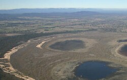 Plains east of Lake Toolondo and est of the Black Range |
0.56% of CMA region This unit of very low relative relief terrain has major occurrences near Lake Toolondo and west of the Black Range on the southern boundary of the Wimmera CMA region. This low plateau complex is part of the Western Uplands: low elevation plateaux division (2.3). This low plateaux complex of Cainozoic sediments is part of a continuous landform extending from the south (Dundas tableland). It is flanked by subdued ridges and dunefields (Darragan, Quantong) as well as residual fans and aprons (Ullswater) to the north. The level plain is the major landform feature with gently undulating sand plains, swamps/playas and lunettes also occurring. Soils include brown and yellow grey sodic texture contrast soils (Sodosols) with grey and brown cracking clay soil (Vertosols) in local depressions. Sandy soils or soils with a deep sandy surface (Tenosols) occur on the crests and lunettes. Wind erosion is a local issue where topsoils are light textured and exposed. This unit is used for dryland cropping and grazing (sheep, beef cattle). Remnant vegetation communities include Plains Woodland, Creekline Sedgy Woodland, Shallow Sands Woodland, Red Gum Wetland, Plains Grassy Woodland, Heathy Woodland and Cane Grass Wetland. | 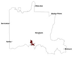 |
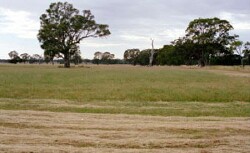
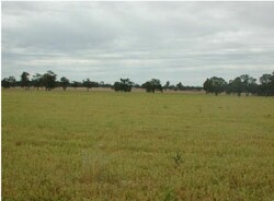 Cropped plains at Telangatuk East | 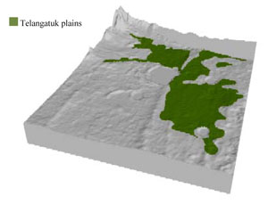 |
 |  Majestic red gum near Telangatuk East |
Component | 1 | 2 | 3 | 4 |
Proportion of soil-landform unit | 10% | 5% | 60% | 25% |
| CLIMATE Rainfall (mm) | Annual: 515 | |||
| Temperature (oC) | Minimum 8, Maximum 20 | |||
| Precipitation less than potential evapotranspiration | October–April | |||
| GEOLOGY Age and lithology | Neogene marine sand and silt (Parilla Sand); Quaternary paludal silt and clay; Neogene marine sand, sandstone, silt laterite (Dorodong Sand); Quaternary alluvial gravel, sand and silt | |||
| Geomorphology | ||||
| LANDUSE | Uncleared areas: water supply; nature conservation Cleared areas: dryland cropping; sheep and beef cattle grazing | |||
| TOPOGRAPHY Landscape | Flat plain | |||
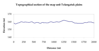
| Elevation range (m) | 149–202 | |||
| Local relief (m) | 1–2 | |||
| Drainage pattern | Dendritic | |||
| Drainage density (km/km2) | 0.5 | |||
| Landform | Gently undulating plains | |||
| Landform element | Swamp/playa | Lunette | Level plain | Sandsheet/plain |
| Slope and range (%) | 0 (0-1) | 5 (3-10) | 1 (0-3) | 3 (1-6) |
| Slope shape | Concave | Convex | Straight | Linear |
| NATIVE VEGETATION Ecological Vegetation Class | Plains Woodland (34.0%), Creekline Sedgy Woodland (18.0%), Plains Grassy Woodland (8.0%), Other 38.0%) | |||
| SOIL Parent material | Paludal silt and clay | Aeolian sand | Marine sand and silt, paludal silt and clay | Aeolian sand |
| Description (Corangamite Soil Group) | Seasonally wet soils: sodic yellow and grey texture contrast soils (33) | |||
| Soil type sites | LSWW11, LSWW17, WLRA74 | LS3, LSWW9, LSWW5 | LSWW11, LSWW17, WLRA74 | |
| Surface texture | Sand | Loamy sand | Loamy sand to medium clay | Loamy sand |
| Permeability | Very slow | Moderate to high | Slow | Moderate to high |
| Depth (m) | > 1.5 | > 1.5 | > 2 | > 1.5 |
| LAND CHARACTERISTICS, POTENTIAL AND LIMITATIONS Critical land features, processes, forms | Susceptible to seasonal inundation, waterlogging and ultimately soil salinity. Upper soils susceptible to sheet erosion and wind erosion when exposed. | Susceptible to wind and sheet erosion where exposed and surfaces with little organic matter. Susceptible to compaction where hardsetting and restricted drainage. Upper soil is susceptible to acidification. | Susceptible to inundation and waterlogging in lower areas. Slightly susceptible to surface sheet erosion where soils are exposed and sandy. Clayey surface soils are friable and only slightly susceptible to wind erosion. Soils susceptible to compaction at critical moisture contents. | Susceptible to wind and sheet erosion where exposed and surfaces with little organic matter. Susceptible to compaction where hardsetting and restricted drainage. Upper soil is susceptible to acidification. |
© State of Victoria (Agriculture Victoria) 1996 - .

This work, Victorian Resources Online, is licensed under a Creative Commons Attribution 4.0 licence. You are free to re-use the work under that licence, on the condition that you credit the State of Victoria (Agriculture Victoria) as author, indicate if changes were made and comply with the other licence terms.
The licence does not apply to ‘branding’ or some ‘images or photographs’ that may be owned by third parties. We ask you to seek prior approval to use images using the VRO feedback form. Access to higher quality images can also be provided on request.
This page was last updated on .