
Soil/Landform Unit - Rainbow hummocky dunes and plains
Landform Unit Description
Page top
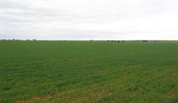
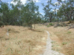 Cropped hummocky plains near Albacutya |
0.37% of CMA region This unit comprises low relative relief terrain of plains and dunes (rises, plains) and depressions found to the north of Lake Hindmarsh. This low depositional plain and undulating siliceous dunefield is part of the North West Dunfields and Plains. These broad plains and dunefields of Quaternary riverine and aeolian sediments occur between Lakes Hindmarsh and Albacutya flanking the Wimmera River unit to the west. Gently undulating plains, dunes, lunettes and drainage depressions occur with little surface evidentexpression. Yellow and brown, and occasionally red sodic texture contrast soils (Sodosols) with deep sandy topsoils occur on plains or with deep sandy soils common on dunes. Grey and brown cracking clay soils are prominent in drainage depressions. Sheet and rill erosion are land degradation threats with wind erosion on the windward side of rises and dunes. Cereal cropping and grazing are major land uses. The main native vegetation communities include; Low Rises Woodland, Ridged Plains Mallee, Riverine Chenopod Woodland, Plains Woodland, Woorinen Mallee, Plains Savannah and Parilla Mallee. | 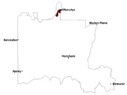 |
 Remnant vegetation on the edge of Lake Albacutya | 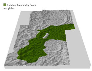 |
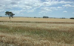
 |  Hummocky plains and rises near Pella |
Component | 1 | 2 | 3 | 4 |
Proportion of soil-landform unit | 30% | 45% | 15% | 10% |
| CLIMATE Rainfall (mm) | Annual: 355 | |||
| Temperature (oC) | Minimum 9, Maximum 23 | |||
| Precipitation less than potential evapotranspiration | September–April | |||
| GEOLOGY Age and lithology | Quaternary paludal silt and clay; Neogene marine sand and silt (Parilla Sand); Quaternary Aeolian lunettes, sand, silt and clay | |||
| Geomorphology | ||||
| LANDUSE | Uncleared areas: Nature conservation Cleared areas: Dryland cropping; sheep grazing | |||
| TOPOGRAPHY Landscape | Undulating plains and low regular dunes | |||
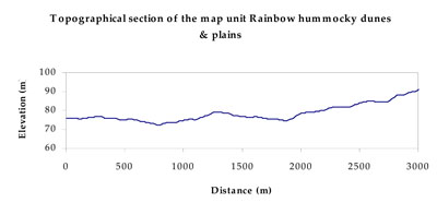
| Elevation range (m) | 70–103 | |||
| Local relief (m) | 5 | |||
| Drainage pattern | Dendritic | |||
| Drainage density (km/km2) | 0.3 | |||
| Landform | Low dunes | Alluvial plains | ||
| Landform element | Hummocky dune | Gentle plain | Lunette | Drainage depression |
| Slope and range (%) | 5 (1-8) | 2 (1-3) | 3 (1-10) | 0 (0-1) |
| Slope shape | Convex | Linear | Convex | Concave |
| NATIVE VEGETATION Ecological Vegetation Class | Ridged Plains Mallee (21.0%), Riverine Chenopod Woodland (17.9%), Plains Savannah (14.8%), Low Rises Woodland (13.4%), Other (30.7%) | |||
| SOIL Parent material | Aeolian sand | Marine sand and silt | Aeolian sand, silt and clay | Paludal silt and clay |
| Description (Corangamite Soil Group) | Sodic yellow and grey texture contrast soils (28) | Calcareous gradational soils (30) | Cracking clay soils (29) | |
| Soil type sites | ||||
| Surface texture | Sandy loam to sandy clay laom | Loamy sand | Sandy clay loam | Fine sandy clay loam |
| Permeability | Moderate | Moderate | Moderate | Slow to very slow |
| Depth (m) | > 2 | > 2 | > 2 | > 2 |
| LAND CHARACTERISTICS, POTENTIAL AND LIMITATIONS Critical land features, processes, forms | Hardsetting surfaces are susceptible to sheet and rill erosion along with wind erosion. Dispersive and deep subsoils susceptible to gully erosion on steeper slopes where exposed. Soils are prone to compaction at critical moisture contents. | Wind erosion along with sheet and rill erosion occur on weakly structured surfaces. Subsoils are dispersive. Soils compact at critical moisture contents. | Well drained surfaces that can be imperfectly drained at depth. Subsoil may be dispersive and subject to erosion where exposed. Surface soil may be susceptible to sheet and wind erosion where a lack of vegetative cover exists. | Soils can be subject to periodic inundation and waterlogging especially in low-lying areas. Soils may be susceptible to compaction. |
© State of Victoria (Agriculture Victoria) 1996 - .

This work, Victorian Resources Online, is licensed under a Creative Commons Attribution 4.0 licence. You are free to re-use the work under that licence, on the condition that you credit the State of Victoria (Agriculture Victoria) as author, indicate if changes were made and comply with the other licence terms.
The licence does not apply to ‘branding’ or some ‘images or photographs’ that may be owned by third parties. We ask you to seek prior approval to use images using the VRO feedback form. Access to higher quality images can also be provided on request.
This page was last updated on .