
Soil/Landform Unit - Natimuk-Douglas valley
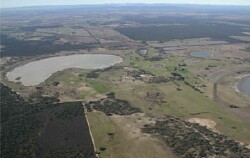 Swamp, lunettes and lakes litter the plains of the Natimuk-Douglas valley |
1.25% of CMA region Also known as the White Lake unit from the Kowree report (1956) and the Lowan unit from soil-landform mapping of the Natimuk 1:100 000 mapsheet (1990), the Natimuk-Douglas valley consists of a valley running north-south with slopes that rise gradually to the east and west. The depression is sharply defined by the Kowree unit to the west and is most likely an extension of the Lowan Salt Valley unit to the north. Blackburn and Gibbons (1956) believed it to be ‘very probable that the unit occupies the site of an old valley through which the Glenelg River or an adjacent stream flowed north before this was captured by dissection extending along the present course of the Glenelg River’. Another theory suggests the Murray River may have once flowed south along the valley and then down the Glenelg River. Today’s landscape is characterised by valley slopes, alluvial plains and valley floor with sodic brown, yellow and grey texture contrast soils (Sodosols) dominant. Compaction is again a major soil degradation issue due to the hardsetting nature of the soils. Land use is mainly dryland cereal cropping with grazing intermixed. Vegetation communities include a number of woodland and wetland associations including Heathy Woodland, Low Rises Woodland, Riverine Chenopod Woodland and Seasonally Inundated Shrubby Woodland. | 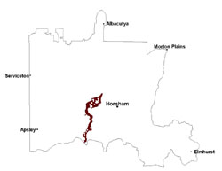 |
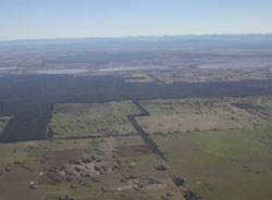 Looking east across Natimuk-Douglas valley towards the uplands | 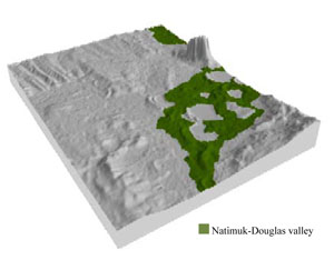 |
 | 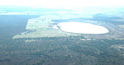 Looking north along the Natimuk-Douglas valley towards Mt Arapiles |
Component | 1 | 2 | 3 | 4 | 5 | 6 | 7 |
Proportion of soil-landform unit | 10% | 25% | 35% | 15% | 5% | 7% | 3% |
| CLIMATE Rainfall (mm) | Annual: 460 | ||||||
| Temperature (oC) | Minimum 8, Maximum 21 | ||||||
| Precipitation less than potential evapotranspiration | October–April | ||||||
| GEOLOGY Age and lithology | Quaternary aeolian dune sand (Lowan Sand); Quaternary paludal silt and clay | ||||||
| Geomorphology | |||||||
| LANDUSE | Uncleared areas: nature conservation Cleared areas: dryland cropping; sheep grazing; gypsum extraction | ||||||
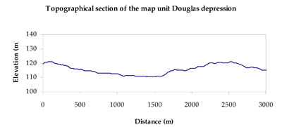
| TOPOGRAPHY Landscape | Shallow depression to valley | ||||||
| Elevation range (m) | 105–174 | ||||||
| Local relief (m) | 15 | ||||||
| Drainage pattern | Centripetal–deranged | ||||||
| Drainage density (km/km2) | 0.7 | ||||||
| Landform | Valley slopes | Alluvial plains and valley floors | Swamp complex | ||||
| Landform element | Upper slope | Lower slope | Gentle plain | Flat | Lunette | Freshwater swamp bed | Saltwater swamp bed |
| Slope and range (%) | 6 (3-12) | 3 (2-10) | 1 (0-5) | 0 (0-2) | 4 (2-12) | 0 (0-1) | 0 (0-1) |
| Slope shape | Convex | Concave | Straight | Straight | Convex | Straight | Straight |
| NATIVE VEGETATION Ecological Vegetation Class | Plains Woodland (37.3%), Shallow Sands Woodland (13.8%), Salt Paperbark Woodland (5.3%), Ridged Plains Mallee (5.1%), Other (34.3%) | ||||||
| SOIL Parent material | Marine silt and clay, aeolian dune sand | Marine silt and clay, aeolian dune sand | Marine silt and clay, fluvial silt and sand | Fluvial silt and clay, minor alluvial gravels, sand and silt | Aeolian and alluvial dune sand and silt | Swamp and alluvial silt and clay | Swamp silt and clay, evaporites and aeolianites |
| Description (Corangamite Soil Group) | Sodic red texture contrast soils (39) | Sodic brown, yellow and grey texture contrast soils (38) | Sodic brown, yellow and grey texture contrast soils (38) | Grey and brown cracking clay soils (37) | Grey and brown cracking clay soils (37) | Seasonally wet soils: sodic yellow and grey texture contrast soils (33) | Seasonally wet soils: sodic yellow and grey texture contrast soils (33) |
| Soil type sites | LSWW11, LSWW17, LSWW13 | LSWW11, LSWW17, LSWW13 | LS3, LSWW9, LSWW5 | LS3, LSWW9, LSWW5 | |||
| Surface texture | Sandy loam | Loamy sand | Loamy sand | Medium clay | Medium clay | Sand | Sand |
| Permeability | Moderate | Moderate | Moderate to slow | Slow | Slow | Very slow | Very slow |
| Depth (m) | > 1.2 | 1.3 | 1.3 | > 2 | > 2 | > 1.5 | > 1.5 |
| LAND CHARACTERISTICS, POTENTIAL AND LIMITATIONS Critical land features, processes, forms | Hardsetting soil surface susceptible to sheet and rill erosion along with wind erosion when exposed. Dispersive and deep subsoils susceptible to gully erosion on steeper slopes. Compaction of upper soil variable depending on soil depth and moisture content. Upper soil is susceptible to acidification. | Susceptible to wind and sheet erosion where exposed and surfaces have little organic matter. Susceptible to compaction where hardsetting and restricted drainage. Upper soil is susceptible to acidification. | Susceptible to wind and sheet erosion where exposed and surfaces have little organic matter. Susceptible to compaction where hardsetting and restricted drainage. Upper soil is susceptible to acidification. | Susceptible to inundation and waterlogging in lower areas, but can be variable due to micro relief (gilgai). Slightly susceptible to surface sheet erosion where soils are exposed. Surface soils friable and only slightly susceptible to wind erosion. Soils susceptible to compaction at critical moisture contents. | Slightly susceptible to surface sheet erosion where soils are exposed. Surface soils are friable and only slightly susceptible to wind erosion. Soils susceptible to compaction at critical moisture contents. | Susceptible to seasonal inundation and waterlogging. Upper soils susceptible to sheet erosion and wind erosion when exposed. | Susceptible to seasonal inundation, waterlogging and ultimately soil salinity. Upper soils susceptible to sheet erosion and wind erosion when exposed. |
© State of Victoria (Agriculture Victoria) 1996 - .

This work, Victorian Resources Online, is licensed under a Creative Commons Attribution 4.0 licence. You are free to re-use the work under that licence, on the condition that you credit the State of Victoria (Agriculture Victoria) as author, indicate if changes were made and comply with the other licence terms.
The licence does not apply to ‘branding’ or some ‘images or photographs’ that may be owned by third parties. We ask you to seek prior approval to use images using the VRO feedback form. Access to higher quality images can also be provided on request.
This page was last updated on .